1 The Book of Routes and Realms
The Arabic Book of Routes and Realms (Kitāb al-Masālik wa-l-mamālik) safeguards the first maps we have from the Islamicate world. Created in the fourth/tenth century, the treatise encompassed the Islamicate world from al-Andalus to Sindh. Although the treatise’s authorship remains complicated, modern scholarship attributes it to al-Iṣṭakhrī.1 After first describing the entire world known to him, al-Iṣṭakhrī turned to the realm of Islam (mamlakat al-islām) which he divided into twenty regions. Devoting a chapter to each region, he detailed events, trade, and customs. To help envision the world he portrayed, al-Iṣṭakhrī added a world map and twenty regional maps to the Book of Routes and Realms. As for al-Iṣṭakhrī’s life or career, they remain unknown. Based on the personal accounts he shared in the text, he travelled the Islamicate East.2 However, we do not know whether he did so as a merchant, as a scholar, or as part of the Abbasid administration.
The Book of Routes and Realms functions as a reference book of the Islamicate world for an audience involved in administration. In contrast to previous geographic literature, the Book of Routes and Realms places everything there is to know about a region in one chapter. By laying out every chapter on the basis of similar information, the treatise organises the mamlakat al-islām into comparable units. With no mirabilia, stories, or poems adorning the chapters, the Book of Routes and Realms focuses on the cities and their infrastructure, trade, and history. As the text does not champion one city, region, or ruler, the Book of Routes and Realms was not designed to promote any dynasty or “centre” in the Islamicate world. The treatise rather catered to an audience like secretaries (kuttāb), who required a lay of the land as a general background.
The maps in the Book of Routes and Realms help connect the regions into a panorama of the Islamicate world.3 After outlining all realms and regions in the world map, al-Iṣṭakhrī zoomed in and out of the mamlakat al-islām through the regional maps. Like the text, the maps do not promote any region. Presenting each region with the same items (cities, water, mountains, deserts, routes, and captions) and colours, the treatise instils order across the Islamicate world and makes the regions comparable – a strategy highlighting its purpose as a reference book or regional encyclopedia. Using harmonic shapes and bright colours in all maps, al-Iṣṭakhrī additionally presented the mamlakat al-islām as a beautiful space. Although al-Iṣṭakhrī provided details about trade, culture, and events in the text, he did not translate them into symbols in the maps. In arranging the maps around indexes with captions (elements pointing to objects),4 al-Iṣṭakhrī made sure a non-specialist audience could understand his design. To help identify or memorise the regions, each map features seas or waterways in a prominent shape (except for one map of a desert). These water bodies also serve as links between the regions, allowing the reader to merge individual images into a bigger picture. Considering that neither the text nor the maps emphasise practical information about the terrain or dangers, this picture was designed as an overview rather than travel instructions.
The wish to preserve the Book of Routes and Realms as a tradition of knowledge fuelled the book’s transmission. Comprising sixty copies today, the Book of Routes and Realms circulated for almost a millennium.5 In addition to Arabic versions, three Persian translations emerged in the seventh/thirteenth century, followed by an Ottoman translation in the eleventh/sixteenth century.6 Since most copies maintained al-Iṣṭakhrī’s text and maps, the audience seems to have cherished his work as cultural heritage that was worth saving. Even when turning the treatise into Persian some 300 years after its composition, the translators stayed as close as possible to al-Iṣṭakhrī’s work. Within the entire transmission, no copyist or translator attempted to update the text of the Book of Routes and Realms to reflect power shifts in the mamlakat al-islām after the fourth/tenth century. Staging the Islamicate world in a rather timeless manner appears to have paid off for al-Iṣṭakhrī, whose work outlasted geopolitical changes.
Moreover, many clients treasured al-Iṣṭakhrī’s maps as works of art. While maintaining al-Iṣṭakhrī’s outlines for the regions and the world, various illustrators embellished the maps. For instance in a Persian copy dating from 1083/1672, the illustrator adorned all water bodies with metallic swirls that hint at the time and money invested in creating the manuscript.7 Rather than altering al-Iṣṭakhrī’s design, the ornaments brightened the maps. Whether the owners understood al-Iṣṭakhrī’s elaborate strategy for picturing the Islamicate world or not, they seem to have enjoyed the images as entertainment. By laying out the Islamicate world as a beautiful and harmonic space to begin with, al-Iṣṭakhrī ensured his work appealed to an audience for its images as well.
The Book of Routes and Realms drew most attention throughout the Persianate world. Not only are there more copies in Persian (37) than in Arabic (22), al-Iṣṭakhrī’s work appears not to have reached the Maghreb. Other than in Cairo, no manuscripts of the Book of Routes and Realms have been listed in collections in North Africa. Considering that al-Iṣṭakhrī had devoted little space to the Maghreb in his work, local readers might have preferred authors who emphasised the region, such as the Andalusian al-Bakrī (d. 487/1094).8 In the east, New Delhi marks the boundary for the distribution of the Book of Routes and Realms.9
Across the centuries of its transmission, the Book of Routes and Realms was owned and read by rulers, officials, diplomats, and scholars. For instance, the Mamluk governor in Cairo, Sayf al-Dīn Azbak min Ṭuṭukh al-Atābakī (d. 903/1498), endowed a copy of the Book of Routes and Realms.10 Moreover, the British Army officer Robert Taylor (d. 1852) commissioned a Persian copy in 1835–1836 in Baghdad.11 When ruling Ardabil in 1898, Ali Khan visited the shrine of Sheikh Ṣafī al-Dīn (eponym of the Safavid dynasty). In the adjoining library, he saw the Book of Routes and Realms and ordered a copy for himself.12 While most manuscripts only hint at their trajectory through seals and ownership statements, one Arabic copy reveals the route it took across the Middle East.13 After being created in Cairo in 648/1286, the copy moved to Tripoli, where the secretary ʿAbd al-Kāfī b. Muḥammad b. Aḥmad b. Faḍl Allāh al-Shāfīʿī finished reading it in 755/1354. The copy continued moving north, until the Ottoman sultan Bayezid II (r. 886–918/1481–1512) marked it with his seal in Istanbul.14 Especially in the nineteenth century, European scholars commissioned new copies for personal study, as illustrated by pencil notes in the margins (see below). In turn, readers from the Islamicate world rarely left traces in the manuscripts. Explaining this absence remains a challenge. Some readers might have simply browsed the Book of Routes and Realms, others could have scrutinised it without commenting on the content. Others still might have marvelled at the maps alone. Given the luxurious character of many copies, al-Iṣṭakhrī’s book was treasured as a work of art that could have been flaunted in private or public libraries.15 In fact, several copies going back to one model each confirm that the Book of Routes and Realms was consulted in one place on different occasions.16
Although many copies of the Book of Routes and Realms display empty margins, some do hold notes. Using the extant transmission, I will inspect what kind of notes we find in al-Iṣṭakhrī’s work. Moving from empty margins to more engagement by the copyists and readers, I have identified the following categories, which will be discussed in turn: no comments, corrections/variants only, cross references, adding and enhancing, Orientalist philological notes, and notes not relating to the text. Moreover, I will also discuss visual changes to the maps – although illustrators introduced these changes directly into the maps rather than the margins, I consider them part of commenting on al-Iṣṭakhrī’s treatise.
2 Book of Routes and Realms: Marginalia
2.1 No Comments (Ten Copies)
At least ten copies of al-Iṣṭakhrī’s work remained without comments. Among the copies with completely empty margins, we find both Arabic and Persian manuscripts showcasing the Book of Routes and Realms with elaborate bindings, golden text frames, and professional images.17 Other copies do include words in the margins, but these only hint at the production process. In two Persian copies, the scribes occasionally miscalculated how much text they had to fit on the page and veered into the margin when they needed more space.18 In another Persian copy, we sometimes see headings from the text repeated in the margins. In contrast to notabilia that repeat parts of the text to draw attention to them, the repetitions in this Persian copy rather point to the division of labour during the manuscript’s creation. As for notabilia, words such as “stop” (qif, sometimes highlighted in red ink) usually introduce them and a paraphrase or keyword from the text that follows.19 In this Persian copy of the Book of Routes and Realms however, the words repeated in the margins correspond to the headings in red ink in the text. The repetitions seem to have signalled to the rubricator which words to highlight after the copyist had finished.20 Additionally, they might have been added by a reader to facilitate finding an interesting passage.
2.2 Corrections (Ten Copies)
Ten copies with maps contain corrections. Accompanied by “correct/sic” (ṣaḥḥa), copyists would place notes in the margins to indicate corrections, alternative spellings as well as text variants.21 Considering the Book of Routes and Realms evolved in different Arabic versions and the third Persian translation circulated in two forms, indicating variants in the manuscripts comes as no surprise. However, ṣaḥḥa serves different purposes in the Book of Routes and Realms. In a Persian manuscript, a copyist had skipped a sentence that he then added in the margin, using ṣaḥḥa to mark it as belonging to the main text.22 The same applies to one of the oldest Arabic copies (MS Leiden, Universitaire Bibliotheken Leiden, Or. 3101) holding several short passages in the margins.23 Rather than indicating variants of the Book of Routes and Realms, the notes in MS Or. 3101 represent sentences the copyist had realised he had omitted – as flagged by the line above the part where the omission occurred. We find the same practice scattered across other copies as well.24 In an Arabic copy containing similar ṣaḥḥa notes, the copyist also pointed to variants on various occasions. For instance, when the distance between Medina and al-Furʿ is indicated as four days (of travel),25 the copyist referred to “another copy” that gave four miles for the distance.26 As several copies have lost their margins due to damage or trimming (sometimes during restoration),27 other copies might have indicated corrections and text variants as well.
2.3 Cross References (Three Copies)
Three Arabic copies with maps contain cross references in addition to other marginalia. Despite many margins being missing due to tearing and restoration, some marginalia have been preserved in MS London, National Maritime Museum, P/3. For instance, when the city of Kufa is mentioned in the chapter about Iraq, a reader started referencing a book by the polymath Muḥammad b. Zakariyyāʾ al-Rāzī (d. 313–323/925–935), known in medieval Europe as Rhazes.28 Unfortunately, the page has been torn, leaving us in the dark about the genre and information the reader wished to share. By contrast, the copy mentioned above that moved from Cairo to Istanbul (MS Istanbul, Topkapı Sarayı Müzesi Kütüphanesi (henceforth Topkapı), A. 3348) contains a long quote from al-Nuwayrī’s (d. 733/1333) encyclopedia The Ultimate Ambition in the Arts of Erudition (Nihāyat al-arab fī funūn al-adab). Introduced by the word “margin” (ḥāshiya), a reader chose the end of al-Iṣṭakhrī’s introduction about the entire world to cite passages from The Ultimate Ambition referring to God creating the world.29 Furthermore, a copy dating from 1086/1675 shows another author and title in the margin. Placed in the chapter about Fārs close to the city Arrajān, the note quotes Ḥamd Allah Mustawfī’s (d. ca. 745/1344) Delight of the Hearts (Nuzhat al-qulūb). Al-Iṣṭakhrī had focused on Arrajān’s size and agricultural products, whereas Mustawfī had named the Sasanian king Qawādh I (r. 488–531 CE) as founder of the city.30 As the reader quoted a Persian treatise in an Arabic manuscript, he reveals he was both learned and bilingual. In the same copy, another hand repeated proper names from the text in the margins, as if to provide an index.31 Moreover, when the governor ʿAlī b. ʿĪsā is mentioned at the end of Fārs, the same hand clarified who he was and that he died in 334/946.32 Next to the colophon in this copy of the Book of Routes and Realms, the reader attributed the treatise to al-Balkhī (d. 322/934), quoting Katip Çelebi’s (d. 1067/1657) bibliographic encyclopedia Kashf al-ẓunūn. Using these cross references, readers contextualised the Book of Routes and Realms in geographic and encyclopedic writing through information they deemed useful.
2.4 Adding and Enhancing (Thirteen Copies)
In thirteen copies, readers sprinkled explanations and enhancements on some pages while leaving the remaining margins empty. Examples include the translator (or copyist) of the Ottoman translation who clarified how to vocalise some words33 and a reader who offered alternative spellings for locations and individuals mentioned in a Persian copy.34 In a similar vein, a copyist added short glosses introduced by the word “margin” (ḥāshiya) that explained the text in an Arabic copy.35 Some manuscripts contain one brief addition to the main text, such as a note explaining who ʿAbd al-Raḥmān III (d. 359/961, caliph in Cordoba) was,36 what kind of leather is exported from the Khazar region,37 and that the metropolis Madāʾin used to consist of seven cities, among them al-Rūmiyya.38 In a different manuscript, a reader left a single blessing in the chapter about Iraq. When Muḥammad’s companion Ṭalḥa b. ʿUbayd Allah (d. 36/656) is mentioned in the text, the reader added “God bless him” (raḍiya Allāhu ʿanhu).39 While blessing or cursing individuals fits reading practices in the Islamicate world, the reader could have eulogised other individuals as well. Considering the reader did not bless Muḥammad, Jesus, or Moses when they were mentioned in the Book of Routes and Realms,40 he seems to have opened al-Iṣṭakhrī’s treatise only once, which is when he left the blessing, or lost interest in commenting. Whatever the reason, the addition points to the reader’s lack of engagement rather than enthusiasm.
Once in the manuscript tradition of the Book of Routes and Realms, a reader called Isḥāq brought up his own experience about the Iraqi canal Nahr ʿĪsā: when visiting the holy sites in Karbala and Najaf in 1037/1628, he witnessed a flood.41 Other readers also commented on locations: for instance, one reader clarified that the water surrounding Tinnīs and Damietta stemmed from the Nile and the Mediterranean42 and another pointed out that many Kurds lived in Shahrizor and assaulted travellers.43
One manuscript stands out regarding the number of additions. Among the many notes in probably the oldest copy, held today in Medina, a reader embellished the section about Medina’s valleys. Not only did he quote a qasida (sg. qaṣīda) by the Umayyad poet al-Ṣamma al-Qushayrī (d. ca. 95/714) about the fleeting beauty of the Najd, he also added a grammatical analysis of its meaning, referring to Sībawayhi’s (d. ca. 180/796) authoritative grammar Book (Kitāb).44
Some readers also used the title page to elaborate on geographic knowledge. One reader reported that Jews and Christians believed the earth to be 7000 years old, adding that 4000 years had passed between Adam’s fall to earth and the birth of Muḥammad.45 Once, a reader summarised Ptolemy’s (d. ca. 170) Geography before al-Iṣṭakhrī’s text, which suggests that he connected the treatise to the antique heritage and its continuation in the Islamicate world.46 Taken together, readers used these notes to clarify or expand on the content. However, occurring in only a fifth of the preserved copies of the Book of Routes and Realms, the small number of notes in this category suggests that the treatise did not incite cross references and large debates. As all copies in this group included maps and some were quite luxurious, the quality of the manuscript might have contributed to curtailing comments.
2.5 Orientalist Philological Notes (Six Copies)
Six copies reveal traces of European philologists working with al-Iṣṭakhrī’s treatise. Written in pencil, we find notes providing alternative spellings for toponyms or comparing the text to other copies of the Book of Routes and Realms. In the oldest dated copy, these notes were probably left by the Dutch orientalist Michael de Goeje (d. 1909), who edited al-Iṣṭakhrī’s text for the first time.47 Someone else compared a copy held today in Dublin to the “Berlin copy” (nuskhat Birlīn) that the Austrian orientalist Aloys Sprenger (d. 1893) acquired for the Royal Library in Berlin in 1857. It is probably his notes in English we see in this copy, translating, indexing, and commenting on al-Iṣṭakhrī’s text.48 English notes also appear in the copy commissioned by Robert Taylor,49 possibly his own. Moreover, two manuscripts held today in St. Petersburg offer alternative spellings in Persian, dates for events mentioned in the text, and comments and translations in Latin.50 Given that these notes never relate to the maps, they stress the philological interest of scholars like de Goeje. By discarding al-Iṣṭakhrī’s maps from his edition, de Goeje underlined his priorities (and possibly avoided higher cost for reproducing images).
2.6 Notes Not Relating to the Text (One Copy)
Only the Medina manuscript contains notes not relating to the text. In addition to a barely legible magic formula in Arabic,51 several lines in Greek letters also appear in the copy. As the letters do not make any sense, they probably served as a code – a common practice to conceal names or magic formulae.52 Placed in spaces that had been left empty by the copyist, both notes illustrate how margins and free space served as notepads for the readers.
2.7 Visual Changes (Five Copies)
While readers never commented on al-Iṣṭakhrī’s maps, two manuscripts attest to copyists graphically interacting with the content. Held today in St. Petersburg, a copy shows the map of the Mediterranean, and next to it, somebody sketched the same sea.53 The sketch resembles the way Ibn Ḥawqal (fl. 4th/10th cent.) had depicted the sea in The World’s Image (Ṣūrat al-arḍ). As the same red ink has been used for rubrications in the text, the copyist might have added the image himself. Whether he did so as a visual cross reference to The World’s Image or simply because he had seen the Mediterranean drawn in this fashion somewhere else remains unclear. By contrast, the diagram inserted before the title page of MS Dublin, Chester Beatty Library, Ar. 3007 displays an alternative to al-Iṣṭakhrī’s world map.54 Presenting a circle oriented east and divided into nine sections, the diagram serves as a reference to the (seven) climes from Greek geography. Ptolemy had introduced climes as latitudinal bands in his Geography, which listed coordinates of locations in the respective climes.55 Alluding to this strategy, the diagram in MS Ar. 3007 lists names of locations in the different sections. Although the reading direction within the sections suggests the world was divided into longitudes instead of latitudes, the cardinal points around the diagram clarify that the structure corresponds to Ptolemy’s idea of climes. Considering Ptolemy had not depicted this structure in the way we find in MS Ar. 3007, the diagram indicated a tradition of knowledge rather than a visual motif. Additionally, the diagram includes two sections marking the utmost north and south as uninhabitable due to extreme cold or heat.56 We find this idea in geographic treatises such as Ibn Khurradādhbih’s (d. ca. 300/911) Book of Routes and Realms.57 However, Ptolemy had not incorporated these boundaries of the inhabited world into the clime scheme, so that the nine sections in the circle of MS Ar. 3007 emphasise the diagram as a reference to traditions of knowledge somebody wished to connect to al-Iṣṭakhrī’s Book of Routes and Realms. Since the explanations in the utmost north and south are in Persian, the diagram also points to a bilingual audience of al-Iṣṭakhrī’s treatise.
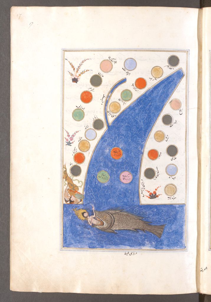
Moreover, three manuscripts demonstrate how illustrators transformed al-Iṣṭakhrī’s maps. Not only do the changes in these manuscripts suggest they served each other as model or copy respectively (possibly through intermediate copies), the copies also reveal that illustrators translated narratives into miniatures. While maintaining all outlines of al-Iṣṭakhrī’s maps, the illustrator filled empty spaces in all regional maps with animals and plants in MS Istanbul, Topkapı, B. 334.58 Moreover, she or he adorned the maps with prophetic and mythical figures in a way that had no basis in al-Iṣṭakhrī’s text. For instance, in the map of the Persian Sea (Baḥr Fāris, encompassing the Red Sea, the Persian Gulf and the Indian Ocean), we find Jonah and the whale with the angel Gabriel. Emerging from a fish’s mouth in the Encircling Ocean, a naked Jonah reaches towards the African shore, where the angel Gabriel is handing him clothing beneath a gourd. The illustrator introduced this motif from other illustrated works he was probably familiar with, such as Rashīd al-Dīn’s (d. 718/1318) Compendium of Chronicles (Jāmiʿ al-Tawārīkh). Although the Compendium does not feature Gabriel in the scene,59 a loose folio dating from approximately 800/1400 shows Gabriel in a design very similar to MS B. 334.60 Why the illustrator linked Jonah to the Persian Sea remains unclear. The Book of Routes and Realms does not mention the prophet in this chapter, nor did Jonah’s journey take him to this sea.61 However, the motif connects MS B. 334 to another Persian copy created in Istanbul in the tenth/sixteenth century (MS Vienna, Österreichische Nationalbibliothek, Cod. Mixt. 344) as well as the Ottoman translation.
The illustrator interpreted al-Iṣṭakhrī’s maps in a freestyle fashion in MS Vienna, Österreichische Nationalbibliothek, Cod. Mixt. 344 – for the first and only time in the entire transmission of the treatise. Bypassing the usual outlines beyond recognition in some cases, the illustrator rearranged the content. For instance, the illustrator reduced the Persian Sea (see Fig. 6.1) to an abstract outline and dispersed the cities across the landmass with no regard for the relative positions al-Iṣṭakhrī had arranged.62 Nevertheless, Jonah, the whale, and Gabriel appear in this map as well. Since MS Istanbul, Topkapı, B. 334 had probably been imported to Istanbul by the tenth/sixteenth century, the copy might have inspired the illustrator of MS Cod. Mixt. 344. In some instances, his transformations suggest an agenda. For instance in the world map, the illustrator moved Mecca to the centre. Not only does this change highlight the religious centre of the Islamic world (for the first and only time in the world map in the transmission of al-Iṣṭakhrī’s book), it might also point to the Ottoman dominance in the Middle East. After defeating the Mamluks in 923/1517, the Ottoman sultan became protector of the holy sites (ḥaramayn) – a role the illustrator might have wished to stress.63 However, he also revealed his geographic shortcomings in the world map. By placing the Maghreb on the northern instead of the southern shore of the Mediterranean, he marked where his knowledge ended rather than pushing an agenda.64

al-Iṣṭakhrī, Ibrāhīm b. Muḥammad: Kitāb Ṣūrat al-aqālīm. MS Vienna, Österreichische Nationalbibliothek, Cod. Mixt. 344 (ca. 1500–1550 CE, Pers.), fol. 17r. With kind permission from the Österreichische Nationalbibliothek
The illustrator for the Ottoman translation took freestyle interpretation to the next level. We search in vain for familiar outlines and content in the maps. Instead, the illustrator portrayed landscapes with plants as well as buildings, but without captions. Rather than identifying the regions through outlines and names as al-Iṣṭakhrī had, the translation alludes to space in general. This style brings to mind Matrakçı Nasuh’s (d. 971/1564) Description of the Stages of Sultan Süleyman’s Campaign in the Two Iraqs (Bayān-i menāzil-i safar-i ʿirāqayn-i Sultān Süleymān Khān). Considering the Ottoman Book of Routes and Realms shows trees, mountains, and cities like the Description, the illustrator might have adjusted al-Iṣṭakhrī’s work to visual trends. Moreover, the illustrator took up motifs from his model (MS Vienna, Österreichische Nationalbibliothek, Cod. Mixt. 344). While the map of the Persian Sea (see Fig. 6.2) bears no resemblance to al-Iṣṭakhrī’s design, Jonah, the whale, and Gabriel help identify the region. Despite remaining an exception in the entire manuscript tradition of the Book of Routes and Realms (around five percent of the existing copies), the three copies discussed here mark al-Iṣṭakhrī’s maps as an arena for updates in the ninth/fifteenth and tenth/sixteenth centuries. In contrast to most illustrators, who reproduced al-Iṣṭakhrī’s design from their model manuscripts, these artists enriched the maps with motifs they knew from the boom in illustrated books and geographic literature at the Ottoman court.65
al-Iṣṭakhrī, Ibrāhīm b. Muḥammad: Kitāb el-Mesālik va el-memālik. MS Bologna, Biblioteca Universitaria di Bologna, 3611 (1598 CE, Ot.), fol. 72r. With kind permission from the Biblioteca Universitaria di Bologna
Except for the map transformations, most clients and readers left hardly any notes indicating how they engaged with the Book of Routes and Realms. However, this silence is not enough for us to assume that the Book of Routes and Realms remained unopened on the shelves. The showcase nature of many copies might have prevented readers from “littering” the margins. While some individuals stated they had read or owned a copy of al-Iṣṭakhrī’s work, no one recorded public readings in the extant manuscripts. This absence might suggest people studied the Book of Routes and Realms alone or in private settings.
3 Other Treatises and Genres
To examine whether the silence in comments prevails in other geographic treatises and illustrated manuscripts, I have examined thirty manuscripts from different centuries.66 Including illustrated chronicles and the Shāhnāma, the sample covers genres that we know fascinated many readers based on the number of copies preserved. Except for the map transformations,67 the notes in the sample correspond to the types of comments in the Book of Routes and Realms. Rather than serving as an exception, the transmission of al-Iṣṭakhrī’s treatise exemplifies a field of manuscripts that remained without comments for the most part. Starting with notes that do not relate to the text, I will move towards empty margins (no comments) in order to highlight how the notes in the second sample resemble the marginalia discussed so far.
3.1 Notes Not Relating to the Text (One Copy)
The sample outside the Book of Routes and Realms includes one copy with a note that does not relate to the text. In a copy of Ibn al-Wardī’s (d. 861/1457) Pearl of Wonders (Kharīdat al-ʿajāʾib wa-farīdat al-gharāʾib), somebody placed a recipe for musk paste for the throat (nuskhat maʿjūn ʿalā jīd) on the empty page after the text (see Fig. 6.3).68 Listing seventeen ingredients such as sugar, honey, and white pepper in dirham, wiqiyya, and qīrāṭ (weight units), the recipe does not specify how to prepare the paste. Similar to the Arabic spell in the Medina manuscript of the Book of Routes and Realms, this note underlines that some readers exploited empty space as notepads.
Ibn al-Wardī, ʿUmar b. Muẓaffar: Kitāb fī dhikr al-buldān wa-mā fīhā min al-ʿajāʾib wa-l-gharāʾib. MS Istanbul, Süleymaniye Yazma Eser Kütüphanesi, Reisülküttap 1009 (1584 CE, Ar.), fol. 194r. With kind permission from the Türkiye Yazma Eserler Kurumu Baskanlığı
3.2 Comments on Quality (Two or Three Copies)
In two manuscripts, readers gauged the quality of a treatise. When reading about Iraq in al-Muqaddasī’s (d. after 380/990) geography Best Division for the Knowledge of the Regions (Aḥsan al-taqāsīm fī maʿrifat al-aqālīm), a reader was baffled: “Many places are missing, especially the renowned al-Ḥilla.”69 Unprecedented within my samples, another reader reacted to this note. Pointing out the Division had been composed before al-Ḥilla was built by ʿAlī b. Mazyad al-Asadī Sayf al-Dawla (in 495/1102),70 the second reader revealed he knew when al-Muqaddasī composed the treatise.
Another learned man left a less diplomatic note in a copy of Ibn Faḍl Allāh al-ʿUmarī’s (d. 750/1349) encyclopedia Insights into the Realms of Metropolises (Masālik al-abṣār fī mamālik al-amṣār, 25 volumes, one world map). Indicating he borrowed the copy on the title page, the historian al-Maqrīzī (d. 845/1442) fumed over the statement that ʿAbd al-Raḥmān I (d. 172/788) conquered al-Andalus: “You know very well that Mūsā b. Nuṣayr [d. 98/716–717] conquered the Maghreb with Arab tribes […]. Both happened ages before ʿAbd al-Raḥmān entered them. It is really common knowledge!”71 Al-Maqrīzī not only left notes in this copy (volume 5), but also in volume 3. They mostly relate to his home region of Egypt, such as the note regarding Memphis mentioned by al-ʿUmarī: “This is just his imagination. In fact, Memphis, which was Egypt’s capital (madīna) in olden times, is now situated at the edge of al-Jīza known as al-Badrashayn.” For further information, he humbly referred to his own treatise, Lessons and Considerations on the Quarters and Monument (al-Mawāʿiẓ wa-l-iʿtibār fī dhikr al-khiṭaṭ wa-l-āthār).72 Possibly due to his subject knowledge as a historian, al-Maqrīzī left more notes than those who read al-Muqaddasī’s Division. However, both treatises indicate that readers examined details and stressed what contradicted their knowledge. Since the manuscript of the Division included fifteen maps with golden pigments, luxurious copies did not stifle comments in general.
3.3 Adding and Enhancing (Eight Copies)
Four manuscripts show how readers explained the content. In the oldest copy of al-Qazwīnī’s (d. 682/1283) Wonders of Creation (ʿAjāʾib al-makhlūqāt wa-gharāʾib al-mawjūdāt), held today in Munich, readers left many notes. As the margins have been damaged or cut, some notes are incomplete. However, we do find marginalia explaining how to vocalise proper names73 and a note elaborating on the town Tinnīs in the Nile Delta, which is mentioned in the text.74 Although the note is incomplete and hardly legible, it probably added details (like in the copy mentioned above) explaining what water surrounded Damietta and Tinnīs.75 Similar clarifications accompany Sipāhīzāde’s (d. 997/1589) The Clearest Routes to the Knowledge of Countries and Realms (Awdaḥ al-masālik fī maʿrifat al-buldān wa-l-mamālik). Among several notes in an Ottoman copy, a reader added next to the mention of Sinope in Arabic that “ʿIzz al-Dīn Kaykāwūs [Kaykubādh] conquered the city from the infidels in 611” (i.e., 1214 CE).76 Rashīd al-Dīn’s Compendium holds similar notes. In the oldest Arabic copy, a reader linked two lines of text: one states that ʿAbd al-Qādir b. Abī Ṣāliḥ al-Jīlī (al-Jīlānī) died in 561/1166; the other mentions the death of Abū al-Khayb al-Suhrawardī, the parental uncle of (the philosopher) Shihāb al-Dīn al-Suhrawardī, in 563/1168. The reader added that the latter was among the successors (khulafāʾ) of the former.77 In the same copy, somebody gave a “Reader’s Digest” summary of the story about Jonah and the whale in Persian. Above the image displaying this story, a reader recapped this narrative in the new lingua franca in the east of the Islamicate world, as if to reach a broader audience.78
Moreover, readers embellished the content with poetry and narratives. The illustrated wisdom book Kalīla wa-Dimna contains a section about intoxication, stressing that kings suffer from it unless they listen to wise men, ulema (sg. ʿālim, pl. ʿulamāʾ).79 Next to it, somebody quoted a poem by Yazīd b. al-Ṭathariyya (fl. 2nd/8th cent.) about the danger of kings lacking cultured behaviour (adab).80 In adorning the content with something from another genre, the addition resembles the Medina copy of the Book of Routes and Realms. Remaining silent about his source, a reader shared a narrative about the Encircling Ocean in a copy of Mustawfī’s Delight (see Fig. 6.4). According to the note, Satan’s throne is in the Encircling Ocean. Moreover, jinn inhabit the sea and castles float on its surface. Additionally, among the idols that the Himyarite king Abraha Dhū al-Manār had placed in the sea, a green one commands sailors to halt because it marks the end of the sea.81 Showing the reader’s familiarity with myths marking the Encircling Ocean as the limit of the known world,82 the note highlights his language skills as well. Like the Persian comment in an Arabic copy of the Book of Routes and Realms, this Arabic note appears in a Persian treatise.
Mustawfī, Ḥamd Allah: Nuzhat al-qulūb. MS Istanbul, Süleymaniye Yazma Eser Kütüphanesi, Şehit Ali Paşa 1819 (1593 CE, Pers.), fol. 7v. With kind permission from the Türkiye Yazma Eserler Kurumu Baskanlığı
A copy of Ibn Ḥawqal’s The World’s Image holds the only comment within a map I have seen so far. While refraining from commenting on anything else in the manuscript, the reader drew and wrote in the map of the Arabian peninsula. Placed in the Red Sea between the peninsula and Ethiopia (Ḥabasha), we see two opposing semicircles (comprising rows of bricks) that narrow the passage. In between, the reader explained that the drawing represented Bāb al-Mandab, a barrier (connection between Africa and Asia) separated by Alexander the Great.83 Parallel to the reader adding the narrative about the Encircling Ocean, this reader linked the map to myths she or he associated with the Red Sea.
3.4 Corrections (Nine Copies)
Nine manuscripts present corrections in the margins. Marked by ṣaḥḥa, these notes include text the copyist had skipped. Similar to the Book of Routes and Realms, we find lines marking where the omission began above the text in a copy of Yāqūt al-Rūmī’s (d. 626/1229) Lexicon of Countries (Muʿjam al-buldān, part 6).84 Other examples cover al-ʿUmarī’s Insights, Ibn Ḥawqal’s The World’s Image and al-Qazwīnī’s Wonders of Creation, the latter two with illustrations.85 Also featuring maps, an Arabic translation of Ptolemy’s Geography likewise includes notes with ṣaḥḥa that might point to variants.86 Among the manuscripts without illustrations but with ṣaḥḥa notes we find Shams al-Dīn al-Anṣārī al-Dimashqī’s (d. 727/1327) Chosen Passages of Time Regarding the Marvels of Land and Sea (Nukhbat al-dahr fī ʿajāʾib al-barr wa-l-baḥr)87 as well as Rashīd al-Dīn’s Compendium.88
3.5 No Comments (Ten Copies)
As with the corpus of manuscripts of the Book of Routes and Realms, ten manuscripts in my sample of geographic treatises and illustrated manuscripts remained entirely without marginalia. This applies to manuscripts without any images, such as a copy of the Arabic translation of Ptolemy’s Geography,89 as well as those holding hundreds of images, like al-Qazwīnī’s Wonders of Creation and the Shāhnāma.90 Although we know these treatises were in vogue, the manuscripts did not incite any comments.91 Moreover, the copies in my sample lack notes reporting public readings altogether.
4 Conclusion
The manuscripts examined in this paper demonstrate that readers hardly commented on works of geography, cosmography, and other illustrated genres. Most copies of the Book of Routes and Realms and also my second sample of manuscripts remained either without marginalia or included corrections and variants at best. Copies in which readers added information and embellished the text with cross references or narratives constitute the second largest group. As these manuscripts each contain only one or two notes, readers must have expanded on familiar topics they came across rather than scrutinising the entire content. While illustrators have transformed al-Iṣṭakhrī’s maps and philologists have left traces in the Book of Routes and Realms, I have not found similar changes in the second sample. However, the illustration cycles in the Shāhnāma and al-Qazwīnī’s Wonders of Creation have been addressed elsewhere92 and my sample would require extension to warrant a general statement. Nevertheless, illustrations do not seem to be the key to understanding why readers refrained from commenting.
The purpose of geography might explain the lack of comments. Like authors composing geographic texts before him, al-Iṣṭakhrī designed his treatise as an encyclopedia.93 Organising all the information by region, al-Iṣṭakhrī helped the readers look up details about cities and their surroundings. Probably not intended to be read from cover to cover, the Book of Routes and Realms might have invited readers to search for their home town or region. If they spotted a detail they could explain or expand, then they did – in the second sample as well. Based on the few comments in both samples, the treatises seem to have remained on the shelves for the most time rather than being read in a scholastic context and transmitted aurally. However, considering how often the Book of Routes and Realms, the Wonders of Creation, and the Shāhnāma have been copied, readers did take an interest in them, just not for scrutinising in detail.
Owners might have collected geographic and other treatises to display and enjoy them outside “academia”. As for the Shāhnāma and Kalīla wa-Dimna, they might have been read and performed in private circles that did not call for written comments. Moreover, as rulers like Murad III (r. 982–1004/1574–1595) flaunted manuscripts at court and relished reading them in their privy chambers,94 luxury copies of the Book of Routes and Realms and the Wonders of Creation adorned libraries. Both as illustrated manuscripts and as a tradition of knowledge, readers might have cherished them without feeling the need to comment. Much like volumes of the Encyclopaedia Britannica grace bookshelves today, geographic treatises could have offered the option to look up information, while primarily establishing a person as erudite.
List of Manuscripts
Note that the following abbreviations are used for libraries in the text and footnotes:
| Süleymaniye | Süleymaniye Yazma Eser Kütüphanesi |
| Topkapı | Topkapı Sarayı Müzesi Kütüphanesi |
Ali Ekber: Khiṭāynāma
MS Istanbul, Süleymaniye Yazma Eser Kütüphanesi, Reisülküttap 609M (952/1545, Pers.).
Amirutzes: Jughrāfiyā (Translation of Ptolemy’s Geography)
MS Istanbul, Süleymaniye Yazma Eser Kütüphanesi, Ayasofya 2596 (8th–9th/15th–16th cent., Ar.).
MS Istanbul, Süleymaniye Yazma Eser Kütüphanesi, Ayasofya 2610 (8th–9th/15th–16th cent., Ar.).
Anonymous: Kalīla wa-Dimna
MS Paris, Bibliothèque nationale de France, Arabe 3465 (7th/13th cent., Ar.), available online: http://archivesetmanuscrits.bnf.fr/ark:/12148/cc31361k.
Bīcan, Ahmed: Dürr-i Meknūn
MS Istanbul, Süleymaniye Yazma Eser Kütüphanesi, Pertevniyal V. Sultan, 456 (1092/1681, Ott.).
al-Dimashqī, Shams al-Dīn al-Anṣārī: Nukhbat al-dahr fī ʿajāʾib al-barr wa-l-baḥr
MS Istanbul, Süleymaniye Yazma Eser Kütüphanesi, Ayasofya 2945 (744/1343, Ar.).
Ibn Faḍl Allāh al-ʿUmarī: Masālik al-abṣār fī mamālik al-amṣār
Part 3: MS Istanbul, Süleymaniye Yazma Eser Kütüphanesi, Ayasofya 3416 (before 831/1428, Ar.).
Part 5: MS Istanbul, Süleymaniye Yazma Eser Kütüphanesi, Ayasofya 3418 (before 831/1428, Ar.).
Part 9: MS Istanbul, Süleymaniye Yazma Eser Kütüphanesi, Ayasofya 3422 (before 761/1360; Ar.).
Firdawsī: Shāhnāma
MS Berlin, Staatsbibliothek zu Berlin, Diez A fol. 1 (1002/1593, Pers.), available online: http://resolver.staatsbibliothek-berlin.de/SBB000067C000000000.
MS Paris, Bibliothèque nationale de France, Supplément turc 326 (1010–1060/1601–1650, Ott.), available online: https://gallica.bnf.fr/ark:/12148/btv1b8415006c/f1.planchecontact.
Ibn Ḥawqal, Abū al-Qāsim: Kitāb al-Masālik wa-l-mamālik
MS Istanbul, Topkapı Sarayı Müzesi Kütüphanesi, A. 3012 (867/1463, Ar.).
Ibn Ḥawqal, Abū al-Qāsim: Kitāb Ṣūrat al-arḍ
MS Istanbul, Süleymaniye Yazma Eser Kütüphanesi, Ayasofya 2934 (before 865/1461, Ar.).
al-Iṣṭakhrī, Ibrāhīm b. Muḥammad: Kitāb al-Aqālīm
MS Gotha, Forschungsbibliothek Gotha, Ms. orient. A 1521 (567/1172, Ar.), available online: https://bit.ly/2y0gseO.
al-Iṣṭakhrī, Ibrāhīm b. Muḥammad: Kitāb Aqālīm al-arḍ ʿalā al-mamālik al-islāmiyya
MS Istanbul, Süleymaniye Yazma Eser Kütüphanesi, Ayasofya 2971 (879–918/1474–1512, Ar.).
al-Iṣṭakhrī, Ibrāhīm b. Muḥammad: Kitāb al-Ashkāl
MS Bologna, Biblioteca Universitaria di Bologna, 3521 (before 1083/1672, Ar.).
al-Iṣṭakhrī, Ibrāhīm b. Muḥammad: Jughrāfiyā
MS Berlin, Staatsbibliothek zu Berlin, Or. fol. 3177 (1864 CE, Pers.), available online: http://resolver.staatsbibliothek-berlin.de/SBB0000D90700000000.
al-Iṣṭakhrī, Ibrāhīm b. Muḥammad: al-Masālik va al-mamālik
MS London, British Library, IO Islamic 1026 (Ethé 707) (8th/14th cent., Pers.), available online: http://www.bl.uk/manuscripts/FullDisplay.aspx?ref=IO_Islamic_1026.
MS New Delhi, National Museum, 56.96/4 (830–831/1427–1428, Pers.).
MS Tehran, Kitābkhāna-yi Malik, 5990 (before 1012/1603, Pers.).
MS Tehran, Mūza-yi Irān-i Bāstān, 3515 (725/1325, Pers.).
al-Iṣṭakhrī, Ibrāhīm b. Muḥammad: Masālik al-Mamālik
MS Cairo, Institut français d’archéologie orientale, LV 94 (n.d., Ar.).
MS Gotha, Forschungsbibliothek Gotha, Ms. orient. P 36 (before 1014/1606, Pers.).
al-Iṣṭakhrī, Ibrāhīm b. Muḥammad: al-Masālik wa-l-mamālik
MS Istanbul, Arkeoloji Müzeleri, 527 (ca. 7th/13th cent., Ar.).
MS Istanbul, Topkapı Sarayı Müzesi Kütüphanesi, A. 3348 (685/1286, Ar.).
al-Iṣṭakhrī, Ibrāhīm b. Muḥammad: Kitāb al-Masālik wa-l-mamālik
MS Cairo, Dār al-Kutub, Jughrāfiyā 199 (before 904/1499, Ar.).
MS Istanbul, Süleymaniye Yazma Eser Kütüphanesi, Ayasofya 2613 (878/1474, Ar.).
MS Leiden, Universitaire Bibliotheken Leiden, Or. 3101 (589/1193, Ar.), available online: http://hdl.handle.net/1887.1/item:1577846.
MS London (Greenwich), National Maritime Museum, P/3 (before 681/1282, Ar.).
al-Iṣṭakhrī, Ibrāhīm b. Muḥammad: Kitāb el-Mesālik va el-memālik
MS Bologna, Biblioteca Universitaria di Bologna, 3611 (1006/1598, Ott.).
al-Iṣṭakhrī, Ibrāhīm b. Muḥammad: Kitāb Ṣūrat al-Aqālīm
MS Vienna, Österreichische Nationalbibliothek, Cod. Mixt. 344 (ca. 900–950/1500–1550, Pers.).
al-Iṣṭakhrī, Ibrāhīm b. Muḥammad: Kitāb Ṣūrat al-Aqālīm al-sabʿa
MS Istanbul, Topkapı Sarayı Müzesi Kütüphanesi, A. 2830 (before 879/1474, Ar.).
al-Iṣṭakhrī, Ibrāhīm b. Muḥammad: Kitāb Ṣuwar ʿālam [sic]
MS Istanbul, Topkapı Sarayı Müzesi Kütüphanesi, A. 3349 (879–918/1474–1512, Ar.).
MS London, British Library, Or. 5305 (12th/18th cent., Ar.).
al-Iṣṭakhrī, Ibrāhīm b. Muḥammad: Ṣuwar al-aqālīm
MS Berlin, Staatsbibliothek zu Berlin, Sprenger 1 (ca. 1840 CE, Ar.), available online: http://resolver.staatsbibliothek-berlin.de/SBB0000D92500000000.
MS Cambridge, University Library, Or. 947 (1083/1672, Pers.).
MS Medina, Maktabat ʿAbd al-ʿAzīz, ʿĀrif Ḥikmat Juhgrāfiyā 910/7 (ca. 5th/11th cent., Ar.).
al-Iṣṭakhrī, Ibrāhīm b. Muḥammad: Ṣuwar al-aqālīm
MS Dublin, Chester Beatty Library, 3816 (after 1086/1675, Ar.).
MS Hamburg, Staats- und Universitätsbibliothek Hamburg Carl von Ossietzky, Cod. orient. 300 (1086/1675, Ar.), available online: https://resolver.sub.uni-hamburg.de/kitodo/HANSh2431.
al-Iṣṭakhrī, Ibrāhīm b. Muḥammad: Kitāb Ṣuwar al-aqālīm
MS Dublin, Chester Beatty Library, Ar. 3007 (before ca. 709/1310, Ar.).
al-Iṣṭakhrī, Ibrāhīm b. Muḥammad: Ṣuwar al-buldān
MS Oxford, Bodleian Library, Ouseley 373 (696/1297, Pers.).
al-Iṣṭakhrī, Ibrāhīm b. Muḥammad: Tarjuma-yi Masālik va-mamālik
MS Geneva, Khalili Collection, 972 (707–708/1307–1308, Pers.).
al-Iṣṭakhrī, Ibrāhīm b. Muḥammad: Tarjuma-yi al-Masālik va-l-mamālik
MS Cambridge, University Library, Eton Pote 418 (ca. 11th/17th cent., Pers.).
MS Istanbul, Topkapı Sarayı Müzesi Kütüphanesi, B. 334 (ca. 864/1460, Pers.), available online: (only four images) https://goo.gl/E2gj9U.
MS London, British Library, Add. 23542 (1836 CE, Pers.).
MS London, British Library, Or. 1587 (1840 CE, Pers.).
MS Mashhad, Āstān-i Quds-i Rażavī, 5405 (7th/13th cent., Pers.), available online: https://bit.ly/3bq7WDt.
MS Mashhad, Āstān-i Quds-i Rażavī, 5623 (ca. 10th/16th cent., Pers.), available online: https://bit.ly/3fB3jcW.
MS New York City, New York Public Library, Spencer Pers. ms. 9 (1075/1665, Pers.).
MS Paris, Bibliothèque nationale de France, Supplément Persan 355 (ca. 12th/18th cent., Pers.), available online: http://gallica.bnf.fr/ark:/12148/btv1b7200028f/f1.image.
MS Paris, Bibliothèque nationale de France, Supplément Persan 1570 (ca. 12th/18th cent., Pers.), available online: https://gallica.bnf.fr/ark:/12148/btv1b520004762.
MS Paris, Bibliothèque nationale de France, Supplément Persan 1614 (before 901/1496, Pers.), available online: https://gallica.bnf.fr/ark:/12148/btv1b84322644.
MS St. Petersburg, Akademia nauk, B 797 (19th cent., Pers.).
MS St. Petersburg, Biblioteka vostochnogo fakulteta Sankt-Peterburgskogo Gosudarstvennogo Universiteta, 281 (1842 CE, Pers.).
MS St. Petersburg, Institut vostochnykh rukopisey Rossiyskoy akademii nauk, C 610 (1164/1751, Pers.).
MS Tehran, Dānishgāh-i Tihrān, 1331 (incl. 9610) (7th–8th/13th–14th cent., Pers.).
MS Tehran, Kitābkhāna-yi Majlis-i Shūrā-yi Millī, 1407 (1898 CE, Pers.).
MS Tehran, Kitābkhāna-yi Malik, 678/2 (ca. 1878 CE, Pers.).
al-Iṣṭakhrī, Ibrāhīm b. Muḥammad: Kitāb-i Tarjuma-yi al-Masālik va-l-mamālik
MS Istanbul, Süleymaniye Yazma Eser Kütüphanesi, Ayasofya 3156 (8th/14th cent., Pers.).
Jalāl al-Dīn al-Anṣārī al-Maḥallī: Muqaddima fī nīl Miṣr al-mubārak
MS Istanbul, Süleymaniye Yazma Eser Kütüphanesi, Ayasofya 3446 (981/1573, Ar.).
al-Muqaddasī, Muḥammad b.: Aḥsan al-taqāsīm fī maʿrifat al-aqālīm
MS Istanbul, Süleymaniye Yazma Eser Kütüphanesi, Ayasofya 2971M (658/1260, Ar.).
Mustawfī, Ḥamd Allah: Nuzhat al-qulūb
MS Istanbul, Süleymaniye Yazma Eser Kütüphanesi, Şehit Ali Paşa, 1819 (1001/1593, Pers.).
Pīrī Reis: Kitāb-ı Baḥriyye
MS Istanbul, Süleymaniye Yazma Eser Kütüphanesi, Ayasofya 2612 (10th/16th cent., Ott.).
MS Istanbul, Süleymaniye Yazma Eser Kütüphanesi, Yeni Cami 790 (937/1530, Ott.).
al-Qazwīnī, Zakarīyā b. Muḥammad: ʿAjāʾib al-makhlūqāt wa-gharāʾib al-mawjūdāt
MS Baltimore, Walters Art Museum, W. 659 (1129/1717, Ott.), available online: https://art.thewalters.org/detail/3488/turkish-version-of-the-wonders-of-creation-2/.
MS Cambridge, Harvard Art Museum/Arthur M. Sackler Museum, 1972.3 (11th/17th cent., Ar.), available online: https://nrs.harvard.edu/urn-3:HUAM:PDS_1972_3_3_mets.
MS Istanbul, Süleymaniye Yazma Eser Kütüphanesi, Ayasofya 2935 (916/1510, Ar.).
MS Istanbul, Süleymaniye Yazma Eser Kütüphanesi, Ayasofya 2936 (before 10th/16th cent., Ar.).
MS Munich, Bayerische Staatsbibliothek, Cod. arab. 464 (679/1280, Ar.), available online: http://daten.digitale-sammlungen.de/0004/bsb00045957/images/index.html?fip=193.174.98.30&id=00045957&seite=1.
Qorqud b. Bāyazīd: Waṣīlat al-aḥbāb
MS Istanbul, Süleymaniye Yazma Eser Kütüphanesi, Ayasofya 3529 (915/1509, Ar.).
Rashīd al-Dīn: Jāmiʿ al-tavārīkh
MS London, British Library, Add. MS 16688 (ca. 10th/16th cent., Pers.), available online: http://www.bl.uk/manuscripts/FullDisplay.aspx?ref=Add_MS_16688.
MS Edinburgh, Edinburgh University Library, Or. Ms. 20 (705/1306 or 715/1315, Pers.), available online: http://images.is.ed.ac.uk/luna/servlet/s/zh68m2.
Rashīd al-Dīn: Jāmiʿ al-tawārīkh
MS London, Khalili Collection, 727 (714/1314, Ar.).
Sipāhīzāde: Evḍaḥ el-mesālik ilā maʿrifet el-büldān ve-l-memālik
MS Istanbul, Süleymaniye Yazma Eser Kütüphanesi, Yeni Cami 787 (1035/1626, Ott.).
Ibn al-Wardī, ʿUmar b. Muẓaffar: Kharīdat al-ʿajāʾib wa-farīdat al-gharāʾib
MS Istanbul, Süleymaniye Yazma Eser Kütüphanesi, Ayasofya 3338 (921/1515, Ar.).
Ibn al-Wardī, ʿUmar b. Muẓaffar: Kitāb fī dhikr al-buldān wa-mā fīhā min al-ʿajāʾib wa-l-gharāʾib
MS Istanbul, Süleymaniye Yazma Eser Kütüphanesi, Reisülküttap 1009 (992/1584, Ar.).
Yāqūt al-Ḥamawī: Muʿjam al-buldān
Part 6: MS Istanbul, Süleymaniye Yazma Eser Kütüphanesi, Turhan Valide Sultan, 247 (827/1424, Ar.).
Bibliography
Arentzen, Jörg-Geerd: Imago Mundi Cartographica: Studien zur Bildlichkeit mittelalterlicher Welt- und Ökumenekarten unter besonderer Berücksichtigung des Zusammenwirkens von Text und Bild (Munich: W. Fink, 1984).
Bal, Mieke and Norman Bryson: “Semiotics and Art History”, The Art Bulletin 73, no. 2 (1991), pp. 174–208.
van den Berg, Gabrielle and Charles Melville (eds.): The Reception of the Shahnama (Leiden: Brill, 2018).
Berlekamp, Persis: Wonder, Image, and Cosmos in Medieval Islam (New Haven & London: Yale University Press, 2011).
Blair, Sheila S.: A Compendium of Chronicles: Rashid al-Din’s Illustrated History of the World (London: The Nour Foundation; Azimuth Editions; Oxford University Press, 1995).
Blair, Sheila S.: “The Development of the Illustrated Book in Iran”, Muqarnas 10 (1992), pp. 266–274.
Burak, Guy: “Between Istanbul and Gujarat: Descriptions of Mecca in the Sixteenth-Century Indian Ocean”, Muqarnas 34, no. 1 (2017), pp. 287–320.
Carboni, Stefano: The Wonders of Creation and the Singularities of Painting: A Study of the Ilkhanid London Qazvini (Edinburgh: Edinburgh University Press, 2015).
Chandler, Daniel: Semiotics: The Basics (London: Routledge, 2002).
Danilenko, Nadja: Picturing the Islamicate World: The Story of al-Iṣṭakhrī’s “Book of Routes and Realms” (Leiden: Brill, 2020).
Dilke, O.A.W.: “The Culmination of Greek Cartography in Ptolemy”, The History of Cartography, vol. 1, Cartography in Prehistoric, Ancient, and Medieval Europe and the Mediterranean, eds. J.B. Harley and David Woodward (Chicago: University of Chicago Press, 1987), pp. 177–200.
Ducène, Jean-Charles: “al-Bakrī, Abū ʿUbayd”, Encyclopaedia of Islam, THREE, eds. Kate Fleet, Gudrun Krämer, Denis Matringe, et al. (Leiden: Brill, 2011). https://doi.org/10.1163/1573-3912_ei3_COM_24503.
Ducène, Jean-Charles: “Quel est le titre véritable de l’ouvrage géographique d’al-Iṣṭaḫrī?”, Les scribes et la transmission du savoir, ed Christian Cannuyer (Brussels: Société belge d’études orientales, 2006), pp. 99–108.
Ducène, Jean-Charles: “Un nouveaux MS du Ṣuwar al-Aqālīm d’al-Iṣṭaḫrī. Le MS ʿAreft Ḥakamt Ǧuġrāfiya 910/7 (Médine, Maktabat ʿAbd al-ʿAzīz)”, Folia Orientalia 40 (2004), pp. 279–311.
Emiralioğlu, Pınar: Geographical Knowledge and Imperial Culture in the Early Modern Ottoman Empire (Farnham: Ashgate, 2014).
Fetvacı, Emine: Picturing History at the Ottoman Court (Bloomington: Indiana University Press, 2013).
Fragner, Bert G.: Die “Persophonie”: Regionalität, Identität und Sprachkontakt in der Geschichte Asiens (Berlin: Das Arabische Buch, 1999).
Gacek, Adam: Arabic Manuscripts: A Vademecum for Readers (Leiden: Brill, 2009).
de Goeje, Michael J.: “Die Istakhrī-Balkhī Frage”, Zeitschrift der Deutschen Morgenländischen Gesellschaft 25 (1871), pp. 42–58.
Grabar, Oleg and Sheila S. Blair: Epic Images and Contemporary History: The Illustrations of the Great Mongol Shahnama (Chicago: University of Chicago Press, 1980).
Hagen, Gottfried: “Translations and Translators in a Multilingual Society: A Case Study of Persian-Ottoman Translations, Late Fifteenth to Early Seventeenth Century”, Eurasian Studies 2, no. 1 (2003), pp. 95–134.
Hatt, Michael and Charlotte Klonk: Art History: A Critical Introduction to its Methods (Manchester: Manchester University Press, 2006).
Ibn al-Muqaffaʿ: Kalīla wa-dimna (Beirut: Maktabat Ḥasan al-ʿAṣriyya li-l-Ṭibāʿa wa-l-Nashr wa-l-Tawzīʿ, 2009).
Ibn Ḥajar al-ʿAsqalānī, Aḥmad b. ʿAlī: Inbāʾ al-ghumr bi-anbāʾ al-ʿumr, ed. Ḥasan Ḥabashī, vol. 2 (Cairo: al-Majlis al-Aʿlā li-l-Shuʾūn al-Islāmiyya, 1969).
Ibn Khurradādhbih, ʿUbayd Allāh: Kitāb al-Masālik wa-l-mamālik, ed. Michael J. de Goeje (Leiden: Brill, 1889).
İhsanoğlu, Ekmeleddin: Osmanlı coğrafya literatürü tarihi, vol. 1 (Istanbul: İslâm Tarih Sanat ve Kültür Araştırma Merkezi (IRCICA), 2000).
al-Iṣṭakhrī, Ibrāhīm b. Muḥammad: Kitāb Masālik al-mamālik, ed. Michael J. de Goeje (Leiden: Brill, 1927).
al-Iṣṭakhrī, Ibrāhīm b. Muḥammad: Mamālik va masālik tālīf-i Abū Isḥāq Ibrāhīm Iṣṭakhrī: Tarjuma-yi Muḥammad b. Asʿad b. ʿAbdallāh Tustarī, ed. Īraj Afshār (Tehran: Bunyād-i Mawqūfāt-i Duktur-i Maḥmūd-i Afshār, 1994).
al-Iṣṭakhrī, Ibrāhīm b. Muḥammad: Masālik va mamālik: Tarjuma-yi fārsī (al-Masālik wa-l-mamālik) az qarn-i panjum-i/shishum-i hijrī, ed. Īraj Afshār (Tehran: Bungāh-i Tarjuma-yi va Nashr-i Kitāb, 1969).
al-Iṣṭakhrī, Ibrāhīm b. Muḥammad: al-Masālik wa-l-mamālik, ed. Muḥammad J. al-Ḥīnī (Cairo: Dār al-Qalam, 1961).
King, David A.: World-Maps for Finding the Direction and Distance to Mecca: Innovation and Tradition in Islamic Science (Leiden: Brill, 1999).
Krachkovskiy, Ignatiy Y.: Arabskaya geograficheskaya literatura (Moscow: Izdatel’skaya Firma Vostochnaya Literatura RAN, 2004).
Kramers, Johannes H.: “Geography and Commerce”, The Legacy of Islam, ed. Thomas Arnold and Alfred Guillaume (Oxford: Clarendon Press, 1931), pp. 79–107.
Lassner, Jakob: “al-Ḥilla”, Encyclopaedia of Islam, 2nd ed., eds. P. Bearman, Th. Bianquis, C.E. Bosworth, et al. (Leiden: Brill, 2012). https://doi.org/10.1163/1573-3912_islam_SIM_2866.
Maury, Charlotte: “Ottoman Representations of the Two Sanctuaries: From Topographical Diagrams to Perspectival Views”, Roads of Arabia, ed. Ali Ibrahim Al-Ghabban et. al. (Paris: Somogy Art Publishers, 2010), pp. 547–559.
Morgan, David: “Persian as a Lingua Franca in the Mongol Empire”, Literacy in the Persianate World, eds. Brian Spooner and William L. Hanaway (Philadelphia: University of Pennsylvania Museum of Archaeology and Anthropology, 2012), pp. 160–170.
Mustawfī, Ḥamd Allah: The Geographical Part of the Nuzhat al-qulūb, ed. Guy Le Strange (Leiden: Brill, 1915–1919).
Necipoğlu, Gülru: “Visual Cosmopolitanism and Creative Translation: Artistic Conversations with Renaissance Italy in Mehmed II’s Constantinople”, Muqarnas 29 (2012), pp. 1–81.
Nöth, Winfried: “Die Karte und ihre Territorien in der Geschichte der Kartographie”, Text, Bild, Karte, eds. Jürg Glauser and Christian Kiening (Freiburg im Breisgau: Rombach, 2007), pp. 39–68.
Rentz, George: “Bāb al-Mandab”, Encyclopaedia of Islam, 2nd ed., eds. P. Bearman, Th. Bianquis, C.E. Bosworth, et al. (Leiden: Brill, 2012). https://doi.org/10.1163/1573-3912_islam_SIM_0970.
Rubin, Uri: “Abraha”, Encyclopaedia of Islam, THREE, eds. Kate Fleet, Gudrun Krämer, Denis Matringe, et al. (Leiden: Brill, 2009). https://doi.org/10.1163/1573-3912_ei3_COM_22605.
al-Sakhāwī, Muḥammad b. ʿAbd al-Raḥmān: al-Ḍawʾ al-lāmiʿ li-ahl al-qarn al-tāsiʿ, vol. 4 (Beirut: Dār al-Jīl, 1965).
Sezgin, Fuat: Anthropo[geo]graphie, part 1 (Frankfurt am Main: Institut für die Geschichte der Arabisch-Islamischen Wissenschaften an der Johann Wolfgang Goethe-Universität, 2010).
Sezgin, Fuat: Mathematische Geographie und Kartographie im Islam und ihr Fortleben im Abendland: Historische Darstellung, part 1 (Frankfurt am Main: Institute for the History of Arabic-Islamic Science at the Johann Wolfgang Goethe University, 2000).
Sims, Eleanor, Boris I. Maršak, and Ernst J. Grube: Peerless Images: Persian Painting and its Sources (New Haven: Yale University Press, 2002).
Spuler, Bertold: Persian Historiography and Geography: Bertold Spuler on Major Works Produced in Iran, the Caucasus, Central Asia, India and Early Ottoman Turkey, trans. M. Ismail Marcinkowski (Singapore: Pustaka Nasional, 2003).
Staatsbibliothek zu Berlin: “Orient: Handschriftensammlungen. Eine Auswahl”. https://staatsbibliothek-berlin.de/die-staatsbibliothek/abteilungen/orient/sammlungen/handschriften (accessed 7 December 2021).
Streck, Maximilian and Michael G. Morony: “al-Madāʾin”, Encyclopaedia of Islam, 2nd ed., eds. P. Bearman, Th. Bianquis, C.E. Bosworth, et al. (Leiden: Brill, 2012). https://doi.org/10.1163/1573-3912_islam_SIM_4725.
Wensinck, Arend J.: The Ocean in the Literature of the Western Semites (Wiesbaden: Sändig, 1968).
Yoltar, Ayşin: The Role of Illustrated Manuscripts in Ottoman Luxury Book Production: 1413–1520, PhD dissertation, New York University, 2002.
al-Ziriklī, Khayr al-Dīn: Al-Aʿlām: Qāmūs tarājim li-ashhar al-rijāl wa-l-nisāʾ min al-ʿarab wa-l-mustaʿribīn wa-l-mustashriqīn (Beirut: Dār al-ʿIlm li-l-Malāyīn, 2002).
In addition to al-Iṣṭakhrī, al-Balkhī (d. 322/934) and Ibn Ḥawqal (fl. 4th/10th cent.) have been associated with the book’s creation. As al-Balkhī’s geographic work Images of the Climes (Ṣuwar al-Aqālīm) has not been preserved and Ibn Ḥawqal’s treatise The World’s Image (Ṣurat al-Arḍ) differs from the Book of Routes and Realms, I will refer to al-Iṣṭakhrī as the author of the latter. As a result of this complexity, manuscript copies of the Book of Routes and Realms are sometimes not attributed to al-Iṣṭakhrī (by scribes and cataloguers) or carry a different title – the latter is reflected in the titles provided for the manuscripts in the bibliography. See also Danilenko: Picturing the Islamicate World, pp. 49–60; Ducène: “Titre véritable”, p. 100; de Goeje: “Die Istakhrī-Balkhī Frage”; Krachkovskiy: Arabskaya geograficheskaya literatura, pp. 34–35, 95–198; Sezgin: Anthropographie, p. 16.
E.g., al-Iṣṭakhrī: Kitāb Masālik al-mamālik, ed. de Goeje, pp. 17, 42, 318.
Danilenko: Picturing the Islamicate World, pp. 61–88.
Stemming from semiotics, the trio of symbols, icons, and indexes facilitates pinpointing how a map-maker translates cultural conventions to his cartographic design. Symbols are most determined by conventions because they do not resemble the object or cultural aspect they represent. Take numbers and flags, for example. Their shapes and colours only have meaning because a community has agreed on it. By contrast, icons rely more on resemblance than convention, which allows the viewer to understand them without a background in the relevant cultural tradition. Miniature buildings representing cities are typical icons on a map, as are lines representing routes and triangles referring to mountains. As for indexes, they merely point to an event or object rather than resembling it like an icon does. Without captions, indexes may therefore elude decoding if we have no other clues linking them to events or places that the map-maker wished to highlight. Arentzen: Imago Mundi Cartographica, p. 173; Bal and Bryson: “Semiotics and Art History”, pp. 175–176, 189; Chandler: Semiotics, pp. 2, 32; Hatt and Klonk: Art History, pp. 200, 209–210; Nöth: “Die Karte und ihre Territorien”, pp. 54–57.
More copies existed, some of which might come to light in the future. Considering that the earliest extant dated Arabic copy dates from 567/1172 – MS Gotha, Forschungsbibliothek Gotha, Ms. orient. A 1521 (567/1172, Ar.; note that when referring to manuscripts, I include their (approximate) date and also the language in which they were written) – and that the prototypes of all the Persian translations have not (yet) been found, the manuscript corpus of the Book of Routes and Realms probably reached around seventy copies. The most recent copy, dating from 1898 CE, will be discussed below (MS Tehran, Kitābkhāna-yi Majlis-i Shūrā-yi Millī, 1407). Given that several manuscripts in my survey are filed under a different title and author, manuscript collections might be holding copies of al-Iṣṭakhrī’s work without being aware of this. Moreover, copies have also surfaced in private collections and at auctions; Danilenko: Picturing the Islamicate World, pp. 181–182. Of the sixty copies, I have examined forty-nine on site or as a (sometimes partial or digital) copy. Apart from a few pages, the remaining eleven copies were out of my reach due to security issues or closed libraries or because they had been sold in auctions.
The Arabic editions include different versions of the text (al-Iṣṭakhrī: Kitāb Masālik al-mamālik, ed. de Goeje; al-Iṣṭakhrī: al-Masālik wa-l-mamālik, ed. al-Ḥīnī) and Īraj Afshār edited two of the three Persian translations (al-Iṣṭakhrī: al-Masālik, ed. Afshār; al-Iṣṭakhrī: al-Masālik, ed. Afshār); I analysed the Persian translations in Danilenko: Picturing the Islamicate World, pp. 89–137. So far, I have only found one manuscript of the Ottoman Turkish translation (MS Bologna, Biblioteca Universitaria di Bologna, 3611 (1006/1598, Ott.)), which I discussed in Danilenko: Picturing the Islamicate World, pp. 158–181.
MS Cambridge, Cambridge University Library, Or. 947 (1083/1672, Pers.).
Ducène: “al-Bakrī”.
MS New Delhi, National Museum, 56.96/4 (830–831/1427–1428, Pers.); for a detailed survey, see Danilenko: Picturing the Islamicate World, pp. 214–263.
MS Cairo, Dār al-Kutub, Jughrāfiyā 199 (before 904/1499, Ar.).
MS London, British Library, Add. 23542 (1836 CE, Pers.).
Colophon in MS Tehran, Kitābkhāna-yi Majlis-i Shūrā-yi Millī, 1407 (1898 CE, Pers.).
MS Istanbul, Topkapı Sarayı Müzesi Kütüphanesi (henceforth Topkapı), A. 3348 (685/1286, Ar.).
The colophon of MS Istanbul, Topkapı, A. 3348 states that on a Friday in the last third of Dhū al-Qaʿda 648 (end of January 1286), Muḥammad b. Muḥammad b. Ibrāhīm finished copying the manuscript in Cairo, at the Gate of the Bridge (Bāb al-Qanṭara). As if to narrow down who this Muḥammad was, the same hand added “Shafiʿi by school of law and Egyptian” above the name. Although the addition has not helped me find this copyist from Cairo, two other individuals mentioned they finished reading the manuscript as well: a certain Zayn al-Dīn ʿAbd al-Raḥmān had read the copy in approximately 726/1336 and ʿAbd al-Kāfī b. Muḥammad b. Aḥmad b. Faḍl Allāh al-Shāfīʿī finished reading the copy in Tripoli on 2 Jumādā al-Ākhira 755 (Monday, 24 June 1354). On this day, ʿAbd al-Kāfī (d. 804/1402) was nineteen years old and had probably already begun working as a secretary in Tripoli. Additionally, ʿAbd al-Kāfī gained a reputation for composing poems and prose as well as treatises on history; Ibn Ḥajar al-ʿAsqalānī: Inbāʾ, p. 369; al-Sakhāwī: al-Ḍawʾ al-lāmiʿ, entry 817. I would like to thank Dr. Said Aljoumani for deciphering the notes and indicating further readings. The year indicated in Zayn al-Dīn’s note could be 736/1336; the writing is rather unclear. ʿAbd al-Kāfī specified that Zayn al-Dīn was his maternal uncle and a later entry on the same page informs us that the plague carried him off in Damascus in 749/1348, leaving behind his sons ʿAbd al-Malik and ʿAbd al-Qādir (I would like to thank Dr. Boris Liebrenz for deciphering this part). The two remaining readership notes do not feature any dates or locations. One of them shows the name Yūsuf b. Sālim. The other note refers to a Taqī al-Dīn (changed into ʿAlā al-Dīn) b. Rukn al-Dīn sibṭ (i.e., descendant of) al-shaykh Shihāb al-Dīn al-Kindī, none of whom I have been able to identify.
For instance, MSS Geneva, Khalili Collection, 972 (707–708/1307–1308, Pers.); Istanbul, Topkapı, A. 2830 (before 879/1474, Ar.).
For instance, the model manuscript for the copy Ali Khan had ordered in Ardabil served as model for five other copies; Danilenko: Picturing the Islamicate World, p. 262.
MSS Istanbul, Topkapı, A. 2830 (before 879/1474, Ar.), A. 3349 (879–918/1474–1512, Ar.); Vienna, Österreichische Nationalbibliothek, Cod. Mixt. 344 (ca. 900–950/1500–1550, Pers.); London, British Library, Or. 5305 (12th/18th cent., Ar.), Or. 1587 (1840 CE, Pers.); Berlin, Staatsbibliothek zu Berlin, Or. fol. 3177 (1864 CE, Pers.).
MSS Tehran, Kitābkhāna-yi Malik, 678/2 (ca. 1878 CE, Pers.); Tehran, Kitābkhāna-yi Majlis-i Shūrā-yi Millī, 1407 (1898 CE, Pers.). We also see this in MS Mashhad, Āstān-i Quds-i Rażavī, 5405 (7th/13th cent., Pers.), which includes one comment, which will be mentioned in the section “Adding and Enhancing” below.
Gacek: Arabic Manuscripts, pp. 168–169.
MS Mashhad, Āstān-i Quds-i Rażavī, 5623 (ca. 10th/16th cent., Pers.); like MS Tehran, Kitābkhāna-yi Malik, 678/2, MS 5623 has empty spaces where the maps should have been placed, which suggests that something interrupted the manuscript’s production. As the last person to insert content, the illustrator operated within the spaces left empty by the copyist. Since he did not start his work, the client might have exhausted his funds midway or the order might have been delayed and never finished. Alternatively, the model manuscript might have already displayed gaps instead of maps. Similar circumstances seem to have affected another Persian copy that has gaps instead of maps: MS Cambridge, Cambridge University Library, Eton Pote 418 (ca. 11th/17th cent., Pers.). As for MS Mashhad, Āstān-i Quds-i Rażavī, 5405 (see fn. 18), something else might have caused the incomplete number of maps. Working on both text and maps, the scribe only sketched seven of the twenty-one maps. As he left fourteen additional spaces empty, he was aware that the treatise held more images. Considering he lacked craftsmanship, he might have lost interest in drawing and instead focused on the text.
Gacek: Arabic Manuscripts, pp. 273, 283.
MS New York City, New York Public Library, Spencer Pers. ms. 9 (1075/1665, Pers.), e.g., fol. 52v.
MS Leiden, Universitaire Bibliotheken Leiden, Or. 3101 (589/1193, Ar.), e.g., fol. 51r.
MSS Istanbul, Arkeoloji Müzeleri, 527 (ca. 7th/13th cent., Ar.); Oxford, Bodleian Library, Ouseley 373 (696/1297, Pers.); Istanbul, Süleymaniye Yazma Eser Kütüphanesi (henceforth Süleymaniye), Ayasofya 3156 (8th/14th cent., Pers.); Gotha, Forschungsbibliothek Gotha, Ms. orient. P 36 (before 1014/1606, Pers.); Paris, Bibliothèque nationale de France, Supplément Persan 355 (ca. 12th/18th cent., Pers.), 1570 (ca. 12th/18th cent., Pers.); Cairo, Institut français d’archéologie orientale, LV 94 (n.d., Ar.).
al-Iṣṭakhrī: Kitāb Masālik al-mamālik, ed. de Goeje, p. 18.
MS Dublin, Chester Beatty Library, Ar. 3007 (before ca. 709/1310, Ar.), fol. 16r: ḥāshiya fī nuskhat ukhrā [alā] arbaʿ amyāl (margin: in a different copy [it is] four miles). Unless otherwise indicated, all translations are my own.
For instance, MS Tehran, Mūza-yi Irān-i Bāstān, 3515 (725/1325, Pers.).
MS London, National Maritime Museum, P/3 (before 681/1282, Ar.), fol. 108v.
MS Istanbul, Topkapı, A. 3348 (685/1286, Ar.), fol. 2: fī ṭabāʾiʿ al-bilād wa-akhlāq sukkānihā […]. As I have only partially examined this copy, it might contain more quotes from al-Nuwayrī’s work as well as other treatises.
MS Hamburg, Staats- und Universitätsbibliothek Hamburg Carl von Ossietzky, Cod. orient. 300 (1086/1675, Ar.), fol. 53r; Mustawfī: Nuzhat al-qulūb, ed. Le Strange, p. 129.
For instance on fol. 59v, the name of the mystic theologian al-Ḥallāj (d. 309/922) is repeated in the margin.
MS Hamburg, Staats- und Universitätsbibliothek Hamburg Carl von Ossietzky, Cod. orient. 300 (1086/1675 CE, Ar.), fol. 63r.
MS Bologna, Biblioteca Universitaria di Bologna, 3611 (1006/1598, Ott.).
MS Geneva, Khalili Collection, 972 (707–708/1307–1308, Pers.).
MS Dublin, Chester Beatty Library, Ar. 3007 (before ca. 710/1310, Ar.); for instance on fol. 16r next to the mention of al-Jār being a port (furḍa), the copyist wrote: ḥāshiya al-furḍa al-sharīʿa (margin: the great port).
MS Tehran, Kitābkhāna-yi Malik, 5990 (before 1012/1603, Pers.), fol. 4v; not only did the reader leave his name in the copy (Suhayl Khūnathāyī), he also provided the year for his comment as 1323 AH Shamsī, i.e., 1944–1945 CE. Considering he briefly pointed out when the Book of Routes and Realms was created on the opening page, Khūnathāyī aimed at contextualising the treatise in a similar fashion to the reader attributing the text to al-Balkhī (MS Hamburg, Staats- und Universitätsbibliothek Hamburg Carl von Ossietzky, Cod. orient. 300).
MS Istanbul, Süleymaniye, Ayasofya 2613 (878/1474, Ar.), fol. 55r; among the export goods from the region, al-Iṣṭakhrī had mentioned the leather of the fisher or beaver (al-khazz, mammal) and the copyist specified the type of fisher or beaver (al-khazz al-ʿandas (?)). Khazz can also mean “silk” or “cloth”, but al-Iṣṭakhrī wrote about leather (julūd) being exported, a word which is taken up in the note.
Arabic name for the city the Sasanian king Khusraw I Anūshirvān (r. 531–578) built for captives taken from Antioch in Syria; see Streck and Morony: “al-Madāʾin”; MS Paris, Bibliothèque nationale de France, Supplément Persan 1614 (before 901/1496, Pers.), fol. 27r.
MS Mashhad, Āstān-i Quds-i Rażavī, 5405 (7th/13th cent., Pers.), fol. 52v.
All of whom are blessed in, for instance, MS Tehran, Kitābkhāna-yi Malik, 5990 (before 1011/1603, Pers.).
MS Tehran, Dānishgāh-i Tihrān, 1331 (incl. 9610) (7th–8th/13th–14th cent., Pers.), fol. 37v.
MS Istanbul, Süleymaniye, Ayasofya 2971 (878–918/1474–1512, Ar.), fol. 18v.
MS London, British Library, IO Islamic 1026 (Ethé 707) (8th/14th cent., Pers.), fol. 54v; the same note was copied in MS Cambridge, Cambridge University Library, Eton Pote 418 (ca. 11th/17th cent., Pers.), fol. 90r.
al-Ziriklī: al-Aʿlām, p. 209; MS Medina, Maktabat ʿAbd al-Azīz, ʿĀrif Ḥikmat Juhgrāfiyā 910/7 (ca. 5th/11th cent., Ar.): qāla Ṣammatu bnu ʿAbdi Llāhi al-Qushayrī aqūlu li-ṣāḥibī wa-l-ʿaysu tahwī bi-nā bayna al-munīfati fa-l-ḍamāri / tamattaʿa min shamīmi ʿarāri Najdin / fa-mā baʿda al-ʿashiyyati min ʿarāri […].
MS Bologna, Biblioteca Universitaria di Bologna, 3521 (before 1083/1672, Ar.).
MS Cambridge, Cambridge University Library, Or. 947 (1083/1672, Pers.).
MS Gotha, Forschungsbibliothek Gotha, Ms. orient. A 1521 (567/1172, Ar.); al-Iṣṭakhrī: Kitāb Masālik al-mamālik, ed. de Goeje.
MSS Dublin, Chester Beatty Library, 3816 (after 1086/1675, Ar.); Berlin, Staatsbibliothek zu Berlin, Sprenger 1 (ca. 1840 CE, Ar.); Staatsbibliothek zu Berlin: “Orient”.
MS London, British Library, Add. 23542 (1836 CE, Pers.).
MSS St. Petersburg, Akademia nauk, B 797 (19th cent., Pers.); St. Petersburg, Biblioteka vostochnogo fakulteta Sankt-Peterburgskogo Gosudarstvennogo Universiteta, 281 (1842 CE, Pers.).
Ducène: “MS ʿAreft Ḥakamt Ǧuġrāfiya 910/7”, p. 284.
Gacek: Arabic Manuscripts, p. 245.
MS St. Petersburg, Institut vostochnykh rukopisey Rossiyskoy akademii nauk, C 610 (1164/1751, Pers.), fol. 35v.
MS Dublin, Chester Beatty Library, Ar. 3007 (before ca. 709/1310, Ar.), fol. 1.
Defined by the longest period of daylight within their boundaries: thirteen hours for the first clime, thirteen and a half for the second, and so on up to a period of sixteen hours, which added up to seven climes; see Dilke: “Culmination of Greek Cartography”, pp. 177–180; Hagen: “Translations and Translators”, p. 130; King: World-Maps, p. 27; Sezgin: Mathematische Geographie, p. 77.
va īn mawżūʿ hami kharāb ast va […] garmā va sūzandigī bāshad […] va qanāʿat-i jānivar nīst.
Ibn Khurradādhbih: Kitāb al-Masālik wa-l-mamālik, ed. de Goeje, pp. 4–5.
MS Istanbul, Topkapı, B. 334 (ca. 864/1460, Pers.).
See for instance MS Edinburgh, Edinburgh University Library, Or. Ms. 20 (705/1306 or 715/1315, Pers.), fol. 299r, which is reproduced in Blair: Compendium of Chronicles, p. 86.
MS New York, New York Metropolitan Museum of Art, 33.113; see Sims, Maršak, and Grube: Peerless Images, p. 295.
The Bible tells us the journey took him from Joppa to Tarshish, probably via the Mediterranean (Jonah 1:1–3).
MS Vienna, Österreichische Nationalbibliothek, Cod. Mixt. 344 (ca. 900–950/1500–1550, Pers.), fol. 17r. Some of the changes the illustrator introduced suggest an agenda, others more a lack of knowledge. I discuss possible reasons for the changes in Danilenko, Picturing the Islamicate World, pp. 163–172.
Emiralioğlu: Geographical Knowledge, pp. 16–17. Authors highlighted this event by giving more attention to Mecca and Medina in texts and images. For instance, the Iranian ʿAbd al-ʿAzīz b. Maḥmūd Iṣfahānī presented an illustrated description of the ḥaramayn to Sultan Süleyman I in 927/1521. Moreover, ʿAbd al-Raḥmān Gubari described the sites in great detail in his illustrated Book of the Kaaba (Kaʿbanāma) in 963/1556–1557, and the collection of texts portraying Süleyman I’s reign called the Book of Süleyman (Sulaymānnāma) also included images of the ḥaramayn. See Burak: “Between Istanbul and Gujarat”, pp. 293–302; Maury: “Two Sanctuaries”, pp. 547–559.
I discuss these manuscripts in greater detail in Danilenko: Picturing the Islamicate World, pp. 158–180.
Fetvacı: Picturing History, pp. 4–7; Necipoğlu: “Visual Cosmopolitanism”, pp. 44–45; Yoltar: Illustrated Manuscripts, pp. 85–93.
For the most part, I use copies from the Süleymaniye Yazma Eserler Kütüphanesi in Istanbul. Additionally, I have consulted various digital repositories online.
For studies regarding the illustrations in the Shāhnāma, see for instance Grabar and Blair: Epic Images; van den Berg and Melville (eds.): Reception of the Shahnama.
MS Istanbul, Süleymaniye, Reisülküttap 1009 (992/1584, Ar.), fol. 194r.
MS Istanbul, Süleymaniye, Ayasofya 2971M (658/1260, Ar.), fol. 44r: kathīr min al-buldān fī al-ʿIrāq lam yaʾti dhikruhā khuṣūṣan al-Ḥilla al-mashhūra fī al-ʿālam. Answer by another reader: lammā ṣunnifa hādhā al-kitāb lam takun al-Ḥilla ʿumirat wa-rubbamā ʿamarahā baʿda dhālika Mazyad b. Zubayd [?].
Lassner: “al-Ḥilla”.
MS Istanbul, Süleymaniye, Ayasofya 3418 (before 831/1428, Ar.), fol. 4v: fa-qad lā yakhfā ʿalayka maʿa iṭṭilāʿiki anna Mūsā b. Nuṣayr dakhala ilā al-Maghrib bi-ṭawāʾif al-ʿarab […] wa-dhālika qabla dukhūl ʿAbd al-Raḥmān bi-dahr wa-laysa hādhā min khafī al-akhbār bal min mashhūrihā ghayr anna al-taʿaṣṣub ḥamalaka ʿalā dhālik.
MS Istanbul, Süleymaniye, Ayasofya 3416 (before 831/1428, Ar.), fol. 156v: hādhā wahmuhu Manf allatī hiya madīnat arḍ Miṣra fī al-qadīm innamā hiya al-ān fī ṭaraf al-Jīza tuʿraf bi-l-Badrashayn la-hā ʿindī fī kitāb al-iʿtibār bi-dhikr al-khiṭaṭ wa-l-āthār ʿiddat akhbār.
MS Munich, Bayerische Staatsbibliothek, Cod. arab. 464 (679/1280, Ar.), fol. 3r.
MS Munich, Bayerische Staatsbibliothek, Cod. arab. 464 (679/1280, Ar.), fol. 69r.
Fewer, but similar, notes are found in another copy of al-Qazwīnī’s Wonders of Creation: MS Istanbul, Süleymaniye, Ayasofya 2936 (before 10th/16th cent., Ar.), e.g., fol. 71r.
MS Istanbul, Süleymaniye, Yeni Cami 787 (1035/1626, Ott.), fol. 114r: iftataḥahā min yad al-kuffār ʿIzz al-Dīn Kaykāwūs al-Saljūqu fī sanatin iḥdā ʿashr wa-sittum[iyya].
MS Edinburgh, Edinburgh University Library, Or. Ms. 20 (705/1306 or 715/1315, Pers.), fol. 109r: wa-huwa min khulafāʾ al-sayyid ʿAbd al-Qādir […] al-madhkūr raḍiya Allāhu ʿanhu.
MS London, Khalili Collection, 727 (714/1314, Ar.), fol. 299r; Blair: “Illustrated Book”, pp. 269–270; Fragner: Persophonie, p. 69; Morgan: “Persian as a Lingua Franca”, p. 161; Spuler and Marcinkowski: Persian Historiography and Geography, p. 25.
Ibn al-Muqaffaʿ: Kalīla wa-Dimna, p. 23.
MS Paris, Bibliothèque nationale de France, Arabe 3465 (7th/13th cent., Ar.), fol. 13v.
MS Istanbul, Süleymaniye, Şehit Ali Paşa, 1819 (1001/1593, Pers.), fol. 7v: iʿlam anna al-muḥīṭ huwa al-baḥr al-aʿẓam alladhī minhu māddat jamīʿ al-biḥār al-muttaṣila wa-l-munfaṣila wa-huwa baḥr lā yaʿrifu lahu sāḥil wa-lā yaʿlimu lahu ʿumq illā Allāh. Wa-l-biḥār alladhī ʿalā wajh al-arḍ khuljān minhu wa-fī hādhā al-baḥr ʿarsh Iblīs laʿanahu Allāh. Wa-fīhi madāʾin taṭfū ʿalā wajh al-māʾ wa-hiya ahluhu min al-jinn fī muqābalat al-rubʿi al-kharāb min al-arḍ wa-fīhi ḥuṣūn wa-quṣūr taẓharu ʿalā wajh al-māʾ ṭāfiyatan thumma taghību wa-taẓharu fīhi al-ṣuwar al-ʿajība wa-l-ashkāl al-gharība thumma taghību fī al-māʾ. Wa-fīhi al-aṣnām alladhī waḍaʿahā Abraha Dhū al-Manār al-Ḥimyar qāʾimatan ʿalā wajh al-baḥri wa-hiya thalāth aṣnām aḥaduhum akhḍar wa-huwa yūʾmiʾu bi-yadihi ka-annahu yushīru ilā nafsihi wa-yukhāṭibu man rakaba hādhā al-baḥr an yaqifa ʿindahu wa-lā yatajāwazuhu; Rubin: “Abraha”.
The idea of a mighty ocean enclosing the world existed in Middle Persian, Greek, and Semitic traditions; see Kramers: “Geography and Commerce”, p. 83; Wensinck: The Ocean, pp. 24–26, 41–43.
MS Istanbul, Topkapı, A. 3012 (867/1463, Ar.), fol. 9v: Bāb al-Mandab wa-huwa al-sadd alladhī fataḥahu al-Iskandar ʿalayhi al-salām; Rentz: “Bāb al-Mandab”.
MS Istanbul, Süleymaniye, Turhan Valide Sultan, 247 (827/1424, Ar.), e.g., fol. 1v.
MSS Istanbul, Süleymaniye, Ayasofya 3422 (before 761/1360, Ar.), Ayasofya 2934 (before 865/1461, Ar.), Ayasofya 2935 (916/1510, Ar.); see also MS Cambridge, Harvard Art Museum/Arthur M. Sackler Museum, 1972.3 (11th/17th cent., Ar.).
MS Istanbul, Süleymaniye, Ayasofya 2610 (8th–9th/15th–16th cent., Ar.).
MS Istanbul, Süleymaniye, Ayasofya 2945 (744/1343, Ar.).
MS London, British Library, Add. MS 16688 (ca. 10th/16th cent., Pers.); see also MS Istanbul, Süleymaniye, Ayasofya 3529 (915/1509, Ar.).
MS Istanbul, Süleymaniye, Ayasofya 2596 (8th–9th/15th–16th cent., Ar.); another such manuscript without images and with no marginalia is MS Istanbul, Süleymaniye, Reisülküttap 609M (952/1545, Pers.).
MSS Baltimore, Walters Art Museum, W. 659 (1129/1717, Ott.); Berlin, Staatsbibliothek zu Berlin, Diez A fol. 1 (1002/1593, Pers.); Paris, Bibliothèque nationale de France, Supplément turc 326 (1010–1060/1601–1650, Ott.); Istanbul, Süleymaniye, Ayasofya 3338 (921/1515, Ar.), Ayasofya 2612 (10th/16th cent., Ott.), Yeni Cami 790 (937/1530, Ott.), Ayasofya 3446 (981/1573, Ar.), Pertevniyal V. Sultan, 456 (1092/1681, Ott.).
For instance, al-Qazwīnī’s Wonders of Creation was a hit in Istanbul in the tenth/sixteenth century, inspiring several translations and adaptations. Among them was Ahmed Bīcan’s (d. after 870/1466) Ottoman translation in 857/1453 as well as his own spin-off called the Hidden Pearls (Dürr-i meknūn). Bīcan’s translation has been preserved in forty-eight manuscripts, the earliest dating from 974/1566 and the most recent from the thirteenth/nineteenth century. Although copies from the ninth/fifteenth century have not come to light yet, Bīcan’s translation probably existed in several manuscripts during this period. As for the tenth/sixteenth century, Bīcan’s translation appeared in twenty-four copies. See İhsanoğlu: Osmanlı coğrafya literatürü tarihi, pp. 5–7.
Berlekamp: Wonder, Image, and Cosmos; Carboni: Wonders of Creation; van den Berg and Melville (eds.): Reception of the Shahnama.
Danilenko: Picturing the Islamicate World, pp. 49, 58.
Fetvacı: Picturing History, pp. 37–39.