1 Introduction
The study presented in this paper focuses on the valley of Coma1 and the plain of Bergús,2 located in the north-west sector of Cardona municipality, in Barcelona, Spain. The area has an elongated configuration about 12 km long, orientated south-west to north-east and delimited by ridges on each side, with the nucleus of Bergús to the west and the town of Cardona, its castle and the salt valley to the east. The town and castle of Cardona would seem to owe their existence to an extensive deposit of rock salt which forms a mountain mass—the Muntanya de Sal—close to the town. Surveys show that this deposit has been continuously utilised since Neolithic times with open-pit quarries and working terraces still prominent in the landscape. There are particularly high densities of activity in the Roman period as is demonstrated by an abundance of pottery sherds, and recent excavations have revealed a settlement of the Roman Republican period on the northern side of the salt valley associated with the exploitation of this precious mineral. The present-day settlement was established in its current location at the beginning of the 11th century.3
The important role the castle in Cardona played in medieval times to control both access to the salt outcrops and the road network that crossed the central region of Catalonia, is well established. The castle is first mentioned in A.D. 798.4

Map of the area under study with the mentioned sites in the text. Author’s work based in a plan drawn by Helena Rovira on request for this article
ILLUSTRATION: L. MCMAHON
Apart from articulating the territory via that network of castles, control of the dominion was guaranteed, on a smaller scale, by a chain of watchtowers, beacons and other complexes distributed around the main roads and valleys providing access to the salt outcrops. Recent studies into the character and distribution of these lesser sites and their roles in the defensive system, as well as the systems of communication between them, have enabled us to define its typology according to the form and extension of their structures. It has also helped us trace the relationship between sites and the local population, between the castle and its tower, and to reconstruct the territory that, broadly speaking, coincides with the medieval castral domain. Surveys carried out in the early 1990s5 gave some indication of the structure of one such territory, comprising the salt valley where the mineral was mined and exploited, the fortress that ensured control over it, and the village or urban core which developed around its base.
This current approach,6 has involved prospecting the territory again, clearing and conducting a topographical survey of some of the structures, analysing historical written and cartographic sources as well as the toponomy and, finally, also reviewing the results of the excavations carried out in the 1990s on one of them, Puig de Palà: the only one that has been the subject of archaeological investigation (see Figure 9.1).7
2 Reconstructing a Landscape of Control
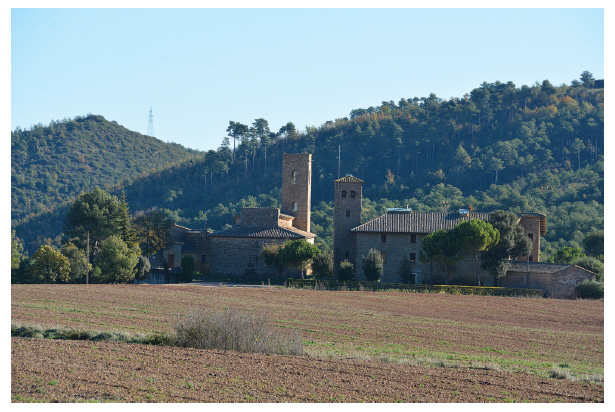
Bergús (Figure 9.2) is located on a wide and fertile plain with abundant hydrographic resources, which naturally and historically constitutes a crossroads between the mountainous area of the pre-Pyrenees to the north, the area of Barcelona and its harbour to the south, and the dry, rain-fed land to the west. The importance of this last location explains the presence of imposing towers, such as Ardèvol, Vallferosa and Peracamps, that control the area. In Bergús there is a concentrated dwelling nucleus with various components, including the Romanesque church of Sant Joan and its associated cemetery (described by Prim Bertran8 when studying anthropomorphic graves associated with the church),
The nucleus of Bergús from the south, near the disappeared tower of Boixader. On the left is one of the towers under study, Torre Pilota.
PHOTO: A. PANCORBO
Around Bergús, a series of archaeological sites, identified as watchtowers, can be found along the ridge flanking the valley both to the east—in the direction of the castle—and to the west. In this latter direction, we find three sites close to Bergús exhibiting the same kind of structures and extension. From north to south, they are Anglerill, Simats and La Torre (near Torrescassana) (see Figure 9.1). Of these three sites only Simats (1.5 km west from Bergús) lies in the current municipality of Cardona. Subsequent remodelling of the site obscures its original layout, and all that remains is a round tower, about 5 m in diameter. Nevertheless, both Anglerill (1.3 km north of Simats) and La Torre (2.8 km to the south), correspond to the typology: in each case a tower presides over a set of dwelling remains, whose function is yet to be determined. The Anglerill tower is rectangular, while the La Torre one is circular.
Focusing again on Bergús, from the tower it is also possible to see Torre Pilota (600 m north-west), les Torretes de Casablanca (620 m east), the summit of Matamoros (1.4 km north-east), and—before it was razed—it was also possible to see the tower of Boixader (about 960 m south-east). In each of these four cases, the towers are circular, and of the two that are amenable to more detailed survey, the towers have a 5 m diameter and numerous structures on their south-eastern slopes, covering an area of 350–400 m2. In front of the tower of Matamoros, on the other side of the valley, 1 km away and always directly intervisible, is the tower of Esgarrapallops, which is also intervisible with Casablanca. From these two sites, one can also glimpse the castle of Cardona, about 5.5 km to the east. However, the network of watchtowers continues to follow a similar pattern, i.e. standing about 1 km apart.
The town, in addition to being walled since the 11th century,12 was also protected from any approach down the valley by two towers, known as Les Torres (‘the towers’) which, despite disappearing sometime in the 19th century, are widely documented in both 14th century written sources and the many military plans of Cardona and its castle drawn up in the 17th and 18th centuries (Figure 9.3).13 On the northern side of the town, there were also two more towers mentioned in the 14th century, one in the west—torre de n’Odeny—and another in the east, known as la Bestorre, where later the hospital of St. James would be built. Despite not being recorded until the 14th century, it can be assumed that both existed prior to the documentary references.
Drawing of the northern slope of Cardona and its castle, dated from 1807. It can be seen from left to right, the castle, the walled village with one of the round towers mentioned in the text and the two towers known as Les Torres. Unknown artist. Historical Archive of Cardona.
The topographical survey of these sites leads us to conclude that they correspond mostly to four different types. First, there is Puig de Palà (Figure 9.4). It is located halfway up the southern ridge and is visually connected to Bergús and the vast majority of other sites. With an area of more than 2,700 m2, it is almost seven times larger than the others. The whole ensemble is presided over by a tower that is 7 m in diameter and surviving to a height of more than 3 m, radially surrounded by dwelling remains arranged in a rectangular grid, within one of which an oven was identified. To the south of the tower, there are
Aerial view of the archaeological site of Puig de Palà
PHOTO: C. PALà
The place-name Palà refers to the term palatium, which we must connect to the reference ‘ipsa curte morischa’ in written sources. Pierre Bonnassie,14 followed by Flocel Sabaté,15 and recently and in more depth the Ocorde research group from the Autonomous University of Barcelona,16 have associated palatia with power nuclei from which public lands attached to the first Andalusian state were managed. In central Catalonia these palatia are mostly located on the Rivers Llobregat and Cardener, their tributaries, and the main roads. This fact also emphasises Puig de Palà as a property with a differentiated status, associated in some way both to the origins in the early Middle Ages of Bergús and the castle of Cardona. When it comes to the owners, the first reference to this site, from A.D. 1005, describes how Viscount Ramon of Cardona, together with his wife and children, donated this place (‘in locum ubi dicitur podium de Palacio’) in favour of spouses Ermemir and Serena.17 As will be seen, this pattern of changed ownership occurs in several of the sites studied.
A second type, located exceptionally down the valley, is represented by ‘the towers of Marbà’. Although physical remains for the tower—implied by the place-name and known traditionally—could not be established by our exploration, a great number of structures can clearly be recognized, including public and private spaces concentrated across an area of about 1700 m2. The whole complex was surrounded by a second wall comprising in total an enclosure of about 4000 m2. Written sources from the 11th century refer to this place as ‘locum quem vocant Celatam’, using the term celar ‘to hide’, which might give some indication to the function of the site. It has direct inter-visibility with Bergús, Casablanca, Boixader, Matamoros, Torre Pilota and Esgarrapallops, all of them located at distances of between 300 m and 1200 m from it, which indicates the strategic importance of this location.
Finally, the sites of Pla de les Àligues, to the north-east, and La Torre del Serrat del Vilar, to the south have a rectangular plan of less than 6 m on each side. Other squared structures lie on the northern slopes, but have smaller dimensions to those mentioned above, although they are probably affected by agricultural works that have reduced their dimensions.
In the great majority of the sites that have been explored and cleared, it has been possible to recover some sherds of medieval grey pottery which can be dated back to around the 11th–13th centuries and, in the case of Puig de Palà, the occupation of the site lasted until the 15th century, as has been proven by archaeological works. Also, the written documentation, together with the archaeological works that took place in the 1990s, reveal that Puig de Palà came to have up to four habitat nuclei.
Although other towers can be found in the rest of the territory of Cardona (e.g. Vironés, La Lloreda, Les Rovires, La Cort), which, typologically, are very similar to those studied and can therefore be assigned to the same period and purpose, these are not concentrated to the same degree. This is probably due to two main factors, the first of which is topographical. The eastern sector of Cardona’s territory is the easiest to enter, both from the valley of Coma and by Planés, a valley located to the south. To the east, the River Cardener makes access to salt much more difficult, while to the north-west and south-east the landscape is more mountainous. Hence, the need to control the Coma depression to avoid being flanked by a surprise attack. This has made sense strategically in terms of defending and controlling the territory and has remained unchanged over time, from the Islamic riots documented from the 8th century18 to the Napoleonic Wars in the 19th century, when the tower of Cardona’s castle was reduced by half, and its base reinforced to accommodate
In relation to this latter conflict (1808–14), it is worth remembering how in the autumn of 1810, part of Marshal MacDonald’s forces flanked Coma from the river valley to access Sant Quintí ridge and Planés, in order to join the bulk of the French troops and face the Spanish soldiers defending Cardona and its castle, on a day that ended with the defeat and withdrawal of the attacking forces.19 In this sense, it is significant that, going back to 1463, with the beginning of the civil war that devastated Catalonia for ten years (1462–72), the town of Cardona organized its defence with night surveillances of the roads of Sant Quintí (Cervera-Lleida), along with Santovà (Berga, Puigcerdà) and Manresa-Barcelona. Also, lookouts were located at certain points of the territory, including the ‘coll de les Àligues’, which is explicitly mentioned, and a toponym coinciding with one of the explored sites.
The second factor has to do with ownership. It must be underlined that all the cases studied here correspond to the demesne of the lords of the castle and its jurisdiction, as we have seen in the case of Puig de Palà. However, already from the first years of the 11th century, the lords began to cede a significant part of this land to the church of Sant Vincenç, as well as to other minor lords, their milites, who, in turn, built towers on their land. This formed a network for controlling the territory through visual communication with each other at short distances, as seen above.
In this regard, a fundamental aspect must be stressed: the central and hierarchical role in this network played by the castle of Cardona and its main tower (known as torre de la Minyona), which belongs to the first phases of the fortress. Built on the summit of the mount, this cylindrical tower, originally about 22 m high, and its courtyard was the reference point for the first enclosure built around it, as is seen also other nearby contemporary castles such as Coaner, Fals or Ardèvol.20
As already mentioned, the first documentary reference we have of the Cardonam castrum is from A.D. 798 when Louis the Pious, son of emperor Charlemagne and then king of Aquitaine, ordered Count Borrell to occupy and fortify the city of Ausona, together with the castles of Casserres and Cardona and other abandoned fortresses. Louis the Pious’s interest in the castle of Cardona
Over the following two centuries the castle maintained its control over the surrounding territory, as evident in the concession made in April 986 by Count Borrell II in granting a second town charter in favour of Cardona and its inhabitants. He did so in order to reaffirm his authority over the southern border following the defeat during the previous summer in the wake of the attack by al-Mansur and the looting of Barcelona. There was no better way to vindicate his own power than by heading the letter with a reference to the first town charter delivered by his grandfather Wilfrid. In the new document, the Count established an obligation for the men of Cardona to work ‘one day a week doing the works of the castle, that is, the towers, walls, embankments and moats that you will dig deep, and this will serve for its safeguarding’. However, in the list of rights and obligations granted at that time, the most important one to understand with regard to the subsequent evolution of the fortress was the cession made in favour of Viscount Ermemir: “I give you as patron, Viscount Ermemir and his successors, in order to follow them when you’ll be asked”. From then until the extinction of the lordship in 1812, Ermemir and his successors held the title of Viscounts of Cardona. The viscounts were responsible for maintaining and controlling the southern boundaries of their county. The transfer of this domain in Ermemir’s favour, as well as the improved control of the castle and consequently the income generated by salt exploitation, meant his centre of power was displaced from the neighbouring county of Osona to Cardona. Furthermore, it is significant to consider the proximity to the southern border and the possibility of obtaining important territorial gains. In A.D. 1000, Viscount Ramon was already titling himself as ‘vicecomites Chardonensis’ to show his patrimonial appropriation of the title and its close relation with the new dominion of Cardona.
The first step taken by the viscount lineage upon occupying the fortress was to delegate the government of the castle to castilians or veguers.21 In Cardona this position remained in the hands of the Brull-Descatllar family, retainers of the counts of Cardona until the 15th century. The castellan was responsible for the castle tower and was obliged to provide the
Another example can be found in the summer of 1369, when, at the request of the lord, the university of the town decided to acquire an indeterminate number of horns or tubas (quasdam tubas sive trombas ad opus dicte ville) at the same time that an impending war with Castile made companies of mercenaries from the south of France a very real threat. The purchase was made in the city of Valencia by Ramon de Niubó, the viscount’s butler, for a price of 117 sous and 5 diners that were remunerated by the administrator of the construction works of the town walls under construction at that time, and so the acquisition could be linked to the defences of the town.24 In this regard, it is interesting to note that in the atrium of the canonical church of Sant Vicenç in the castle of Cardona, is a pictorial representation dating to the 14th century of the siege of the city of Girona (A.D. 1285), featuring a man blowing a horn (Figure 9.5). Therefore, it can also be inferred for that at the time the picture was painted the lookout service in the castle and the blowing of the horn were fundamental for safeguarding the tower and its village, as well as for basic communication with the rest of the territory. This explains why in A.D. 1437 the consul of the town claimed from the count of Cardona the restitution of the figure of the ‘torredà’ when the Brull-Descatllar family abandoned their responsibilities.
Detail of a man blowing a horn in a pictorial representation, from the 14th century, of the siege of the city of Girona (A.D. 1282)
PHOTO: A. PANCORBO
About two centuries later, when the figure of the ‘torredà’ was already a memory of the past, the same tower would house the so-called ‘bell of the service alarm’ (sometent), which invoked the local militia in advance of any danger or threat. This is reflected in documents from the year 1643, when Louis XIII’s French troops took possession of the castle in the middle of the Reaper’s War (Guerra dels Segadors, 1640–52). Then, we are told that the representative of the French king accessed the castle keep where the bell was located (in
3 Conclusion
In light of the above, and focusing again on the network of towers described previously, it would seem that between the 11th and 14th centuries visual
It is also worth mentioning here the research, based on experimental archaeology, carried out by the Art historian Laura de Castellet,25 who experienced the scope of sound produced by horns made of both horn and ceramic in the area immediately adjacent to that of our study. She was able to conclude that the sound of an antler horn could travel a distance of 2 km, a ceramic horn about 3 km, and ceramic tubas could reach up to 5 km. On this basis the sound of a horn from a tower located 17 km south-west of the castle of Cardona, when transmitted through a series of sites similar to those studied here, might take only 4.5 minutes to reach the castle. Consequently, considering the number of towers explored, it must be deduced that by combining both the visual and sound interconnection, Coma, Bergús and the castle and town of Cardona could have had an easy, fluid and probably complex communication.
Bibliography
Primary Sources
Diocesan Archive of Solsona, Fons Cardona.
Library of Catalunya, Batllia de Cardona.
Secondary Sources
Bertran Roigé, Prim. Hallazgo de sepulturas antropomorfas y de una ollita gris en Bergús (Cardona, Barcelona). Acta Historica et Archaeologica Mediaevalia 3. Universitat de Barcelona, 1982: 173–83.
Blanch, Adolfo. Cataluña. Historia de la Guerra de la Independencia en el antiguo Principado. Tomo II. Barcelona: Imp. de Tomàs Gorchs, 1861.
Bolòs, Jordi. “l’arquitectura civil i militar i l’arqueologia.” Catalunya Romànica XXVII: Visió de síntesi, restauracions i noves troballes, bibliografia, indexs generals, 19–62. Barcelona: Enciclopedia Catalana, 1998.
Bonnassie, Pierre. Catalunya mil anys enrera I. Barcelona: Edicions 62, 1979.
Bramon, Dolors. “Rectificació sobre un topònim mal identificat en una algarada dels andalusins conta la plana de Vic i el Bages, l’any 841.” Ausa 185 (2020): 519–21.
Castellet, Laura de. “Cartografia sonora de la comunicació castral. La fonosfera del corn i del dret a cornar a la Catalunya medieval.” Svmma. Revista de cultures medievals 8 (2016): 4–25.
Du Chesne, Andreas, ed. Historia Francorum scriptores coetanei ab ipsius gentis origine ad nostra usque tempora. Paris: Sebastian Cramoisy, 1636.
Galera Pedrosa, Andreu. Diplomatari de la vila de Cardona (anys 966–1276). Diplomataris 15. Barcelona: Fundació Noguera, 1998.
Galera Pedrosa, Andreu. Territori, senyoriu i jurisdicció a la Catalunya Central: la batllia de Cardona (Ducat de Cardona) i la baronia de Santa Maria d’Aguilar (ss. XI–XVI). Unpublished PhD-thesis. Barcelona: University of Barcelona, 2002.
Gibert i Rebull, Jordi. L’expressió material del poder durant la conquesta comtal. Esglésies, castells i torres a la Catalunya central (segles X–XI). Claramunt: Ajuntament de la Pobla de Claramunt, 2018.
Gisbert, Meritxell. Cartografia de Cardona. De la Guerra de Successió a la Guerra del Francès: 1717–1858. Cardona: Ajuntament de Cardona, 2011.
Juan, Mercedes, and Xavier Solé, “Prospecció arqueològica del terme municipal de Cardona (Bages, Barcelona), 1990–1992: primers resultats.” Actes de la XXXIX Assemblea Intercomarcal d’Estudiosos, Cardona, october 22–23, 1994, I. Cardona, (1997): 111–22.
Juan, Mercedes, and Xavier Solé. “L’origen i desenvolupament de la vila de Cardona.” L’església Parroquial de Sant Miquel de Cardona. El gòtic al mig Cardener, 26–32. Manresa, Centre d’Estudis del Bages, 2003.
Martí, Ramon, “El palatium rural, una institución fiscal del siglo VIII.” Lo que vino de Oriente. Horizontes, praxis y dimensión material de los sistemas de dominación en Al-Andalus (siglos VII–IX). Oxford: Archaeopress, 2013: 133–48.
Padilla, José I., and Karen Álvaro, “El sonido de la guerra. Las trompas de la Fortaleza Medieval de Ausa (Zaldibia, Gipuzkoa).” Acta Historica et Archaeologica Mediaevalia 30 (2010): 453–58.
Pancorbo Picó, Ainhoa, Albert Martín Menéndez, and Andreu Galera Pedrosa, “Les intervencions arqueològiques realitzades al camp de futbol de Cardona (Bages): el jaciment del Campet de la Sal.” Tribuna d’Arqueologia 2016–2017, 171–97. Barcelona: Departament de Cultura, 2019.
Rodríguez Bernal, Francesc. Collecció diplomàtica de l’Archivo Ducal de Cardona (965–1230). Diplomataris 71. Barcelona: Fundació Noguera, 2016.
Sabaté, Flocel. El territori de la Catalunya medieval. Percepció de l’espai i divisió territorial al llarg de l’edat mitjana. Barcelona, Rafael Dalmau, 1997.
A Catalan toponym indicating a depression in mountainous terrain.
Unclear etymology, but has traditionally been associated with a demonym of Iberian root, Bargusi, mentioned by Titus Livius and Polybious which could be located in an area delimited to the south by the valley under study.
Ainhoa Pancorbo Picó, Albert Martín Menéndez and Andreu Galera Pedrosa, “Les intervencions arqueològiques realitzades al camp de futbol de Cardona (Bages): el jaciment del Campet de la Sal,” Tribuna d’Arqueologia 2016–2017 (Barcelona: Departament de Cultura, 2019), pp. 171–97.
Andreas Du Chesne, ed., Historia Francorum scriptores coetanei ab ipsius gentis origine ad nostra usque tempora (Paris: Sebastian Cramoisy, 1636).
Mercedes Juan and Xavier Solé, “Prospecció arqueològica del terme municipal de Cardona (Bages, Barcelona), 1990–1992: primers resultats,” (XXXIX Assemblea Intercomarcal d’Estudiosos, Cardona, october 22–23, 1994) (Cardona, Ajuntament de Cardona, 1997), pp. 111–22. Another survey was carried out in 2011 regarding the medieval structures: Jordi Gibert, L’expressió material del poder durant la conquesta comtal. Esglésies, castells i torres a la Catalunya central (segles X–XI) (Claramunt: Ajuntament de la Pobla de Claramunt, 2018).
This study was possible thanks to a grant from the Department of Culture of the Generalitat de Catalunya. The research was carried out with the permission and co-operation of local land owners, to whom we are also grateful.
These works were directed by Dr José Ignacio Padilla and conducted from 1996 to 2000 by a team from the University of Barcelona, including this article’s authors.
Prim Bertran, Hallazgo de sepulturas antropomorfas y de una ollita gris en Bergús (Cardona, Barcelona) (Acta Historica et Archaeologica Mediaevalia) 3 (Barcelona: Universitat de Barcelona, 1982), pp. 173–83.
On the limits of Cardona, in the place called Bergusi, in the same villa.
Francesc Rodríguez Bernal, Collecció diplomàtica de l’Archivo Ducal de Cardona (965–1230) (Diplomataris) 71. (Barcelona: Fundació Noguera, 2016), pp. 90–93.
Written sources from the 13th-century call this tower as La Torre (as the one near Torrescassana) and recently it was catalogued under the name of a neighbouring house (Tower of the mount of can Jaume). This generic name is common all around the country together with ‘torre dels moros’ in allusion to a possible Arabic origin.
Mercedes Juan and Xavier Solé, “L’origen i desenvolupament de la vila de Cardona,” L’església Parroquial de Sant Miquel de Cardona. El gòtic al mig Cardene (Centre d’Estudis del Bages, 2003), pp. 26–32.
Meritxell Gisbert, Cartografia de Cardona. De la Guerra de Successió a la Guerra del Francès: 1717–1858 (Cardona: Ajuntament de Cardona, 2011), pp. 111, 113, 135, 137, 173 and 175.
Pierre Bonnassie, Catalunya mil anys enrera. Economia i societat feudal. Vol I (Barcelona: Edicions 62, 1979).
Flocel Sabaté, El territori de la Catalunya medieval. Percepció de l’espai i divisió territorial al llarg de l’edat mitjana (Barcelona, Rafael Dalmau, 1997).
Ramon Martí, “El palatium rural, una institución fiscal del siglo VIII,” in Lo que vino de Oriente. Horizontes, praxis y dimensión material de los sistemas de dominación en Al-Andalus (siglos VII–IX), ed. Xavier Ballestín and Ernesto Pastor (Oxford: Archaeopress, 2013), pp. 133–48.
Andreu Galera, Diplomatari de la vila de Cardona (anys 966–1276) (Diplomataris) 15 (Barcelona: Fundació Noguera, 1998), pp. 67–68.
This author has recently identified an Arabic toponym mentioned in a fragment of a volume of al-Muqtabis, the chronicle by the historian Ibn Hayyan, as Cardona. This allows us to document an Andalusian incursion against the castle in August-September 841. (D. Bramon, “Rectificació sobre un topònim mal identificat en una algarada dels andalusins conta la plana de Vic i el Bages, l’any 841.” Ausa 185 (2020), pp. 519–21). This raid highlights the leading role of Cardona and its castle in the area of central Catalonia, and provides a much better explanation of the actions by Count Guifré in the 870s when granting a first town charter, which unfortunately has disappeared.
Adolfo Blanch, Cataluña. Historia de la Guerra de la Independencia en el antiguo Principado (Tomo) II (Barcelona: Imp. de Tomàs Gorchs, 1861), pp. 100–04.
Jordi Bolòs, “l’arquitectura civil i militar i l’arqueologia,” Catalunya Romànica XXVII: Visió de síntesi, restauracions i noves troballes, bibliografia, indexs generals (Barcelona: Enciclopedia Catalana, 1998), pp. 19–62.
Rodríguez Bernal, “Collecció diplomàtica,” pp. 36–41.
Galera Pedrosa, “Territori, senyoriu i,” pp. 238–39.
Diocesan Archive of Solsona, Fons Cardona, 3, f. 159r.
Library of Catalunya, Batllia de Cardona, Bat Car 77/3.
Laura deCastellet, “Cartografia sonora de la comunicació castral. La fonosfera del corn i del dret a cornar a la Catalunya medieval,” Svmma. Revista de cultures medievals 8 (2016), pp. 4–25.