1 Introduction
Mediterranean shoresâNorth Africa includedâwere dotted with lookouts and beacons.1 In European timeframes the relevant structures often date to the later Middle Ages or Early Modern periods, as well as before and after. That much is clear from many written and iconographic sources, largely European, from the A.D. 13th to the 16th centuries. Additional evidence, often unique, can be derived from cartographic or quasi-cartographic material such as early sea charts, textual coastal rutters, field sketches, urban plans and vistas, and maps dating from the A.D. 1600s onward. These often correlate with records of political, commercial, artistic, etc., content. A third type of source comprises local heritage listings, but these are not always complete and may uncritically echo older literature with little interest in beacons. Finally, remote spatial imagery
The historical evidence is sparse, usually consisting of only snippets within other material. Thus, tentative attribution of signalling/surveillance roles typically requires multiple data strands. Neither time nor modernization have spared structures. Already denuded sites are also vanishing. More than three-quarters can no longer be usefully surveyed, or have already been erased without valid salvage archaeology. There are issues with dating and cultural attribution, for example by means of surface-collected diagnostic ceramics, in the Moroccan Rif, so assigning viable timeframes is difficult. Beacons also degrade, so their maintenance historically required both leadership and local commitment. They were rebuilt, multiple times, but only in response to apparent emergencies. Furthermore, folk traditions attached to certain sites, recorded in both written sources and oral traditions, keep sidetracking research. Finally, while recorded pre-1950s toponymy is useful for site spotting, place-name continuity has become broken thanks to multiple administrative changes, altered cartographic conventions, and changes in toponymic preferences between the colonial and post-Independence eras. It is not easier but more difficult to retrieve old place names from present-day commercial digital maps.
The project behind the present study tracks known coastal or near-hinterland towers/beacons, from Asilah on the Atlantic shore, through the Strait of Gibraltar, to the Rif (Mediterranean). The database includes over 30 sitesâsome attested quite lavishlyâand c.20 potential sites. The research collates the data types outlined above, with inclusion of published and unpublished chronicles, chancery papers, official and private letters, diplomatic dispatches, tactical reports, travel memoirs, etc. Analysis of the archaeological literature continues, to weed out fragile hypotheses. Aerial imaging of proven or probable sites is also in progress, with in situ ground-truthing taking place wherever feasible (although this has been hampered by COVID-19). The goal of the project is to define a diachronic typology, utilising âtraditionalâ and ânewâ (GISâenabled) landscape archaeology approaches.2 As part of this work, the
2 Historical Baselines and Caveats
Inherent characteristics of beacon/lookout sites far outlasted historical shifts in governance. Even near the Moroccan ports that the Portuguese seized in the A.D. 1400s (starting with Ceuta, 1415), intermittently repurposed sites never really fell out of use. Neither did key features of earlier Islamic urban fortifications. Ceuta, Ksar es-Seghir, Tangier, and Asilah fell to the Portuguese mostly intact (1415â71), and while tactically awkward elements were abandoned, the rest was reused. Modernizing urban defences, at Ceuta or Tangier for instance, continued well past the A.D. mid-1500s.
Even more importantly, the Portuguese takeover did not really result in sudden alterations in surveillance patterns. Crude schemataâe.g. âIslamic town/friendly Islamic hinterlandâ vs. âPortuguese town/hostile Islamic hinterlandââare unrealistic. One cannot simply ignore pre-1471 power dynamics. Islamic portsâthose with a history of separatism, like Ceutaâdid not view their own hinterland or rulers in dynastic capitals like Fez or even more distant Marrakech with any naïve trust. Security concerns existed over inland approaches and rival Christian and Islamic sea traffic. The sea, in turn, was not a priori friendly to the Portuguese. Piracyâregardless of the religion of the crewâremained an issue, as did Maghribi boat raids to get news and hostages, and to test urban defences.
In this context, it is surely useful to have a baseline for the possible extent of any network of beacons in northern Morocco before 1415â71. For now, archaeology does not offer any such. A contour of one is nonetheless available thanks to Ibn MarzÅ«qâs al-Musnad, a celebratory profile of the MarÄ«nid sultan AbÅ« al-Ḥasan âAlÄ«, completed in A.D. 1371.3 The information, albeit succinct, is of
Historian and poet, Ibn MarzÅ«q was admittedly a court panegyrist. His report may involve hyperbole, yet the other concise data he offers regarding fortification upgrades at Ceuta and at Gibraltar are mostly verifiable, including descriptions of the building techniques. Ibn MarzÅ«q was evidently well informed. The beacons he describes ran from Asfi (southern Morocco) to Algiers, with a possible extension into IfrÄ«qiya (Tunisia), probably as far as Béjaïa. Guards at each post watched the sea, the coastline, and the near hinterland. The lit beacons supposedly alerted the entire network in one nightâor even part of a nightâa distance caravans took two months to cover. Given a daily caravan stage of c.16â40 km, this implies some 960â2,400 km, depending on visibility. The distance along the coast from Asfi to Béjaïa is some 1,770 km, which would agree with Ibn MarzÅ«qâs account (Figure 17.1).

Overall model of the MarÄ«nid signal beacon network as described in Ibn MarzÅ«qâs al-Musnad. The model assumes equidistant beacons, and includes 104 stations. The map inset shows certain key localities in the Strait of Gibraltar, for orientation purposes
ILLUSTRATION: M.M. ELBL
Examining the viability of this system, Elbl suggested a simple model, perhaps comprising about 100 to 120 stations at c.11 km to over 17 km intervals.4 On this basis a signal could travel from end to end within 32 hours in clear weather: longer than Ibn MarzÅ«qâs âsingle night,â but still a worthy achievement.
AbÅ« al-Ḥasan cannot have envisaged a viable beacon infrastructure before A.D. 1332â4. Only then did he assert genuine power by eliminating his brother AbÅ« âAlÄ«, backed by the âAbd al-WÄdid rulers of Tlemcen. A campaign against Tlemcen then began in FebruaryâMarch A.D. 1335 (A.H. mid-735). Only after Nedroma fell in JulyâAugust 1335 and Oujda in autumn 1335 to early spring 1336 (A.H. 736), was a compact sector of coastal and inland central Maghrib under AbÅ« al-Ḥasanâs controlâincluding Oran, Honein, Miliana, Ténès, and approaches to Algiers. âAbd al-WÄdid leaders at the borders of Ḥafá¹£id IfrÄ«qiya, who were blockading Béjaïa, defected to AbÅ« al-Ḥasan. Areas south to Médéa, the Chelif Valley and into the Ouarsenis Mountains were then secured. Tlemcen, the âAbd al-WÄdid capital, was isolated. The blockade was enforced from a camp-town at al-Manṣūra (The Victorious), and Tlemcen finally fell to an all-out assault on 7 May 1337 (27 Ramaá¸Än A.H. 737).6
Prior to AprilâMay 1336 (late A.H. 736) at best, or even the spring of 1337 (late A.H. 737), beacons all the way from Asfi to Algiersâor even Béjaïaâwould have made little sense, given need for maintenance and reliable garrisoning. Even patchy command-and-control depended not just on structures but, as Ibn MarzÅ«q highlighted, on loyal guards. Note that, after the fall of Tlemcen, AbÅ« Muḥammad âAbd AllÄh Ibn TÄfrÄjÄ«n, resident at the MarÄ«nid court and in the siege camp as a Ḥafá¹£id official, accomplished the singular feat of reaching Tunis with news of the victory as early as 17â18 May 1337, entirely outpacing official couriers.7 Beacons extending to Algiers, or further east, thus presumably were not in place yet.
Extending the network toward IfrÄ«qiya really mattered only for asserting control. The failure of crucial dynastic talks in A.D. 1337â8 (A.H. 738) created obstacles, as did the rise of pretenders in the MarÄ«nid and Ḥafá¹£id domains.
Only with the death of the Ḥafá¹£id dynast AbÅ« YaḥyÄ AbÅ« Bakr and the rise of his son âUmar in OctoberâNovember A.D. 1346 (A.H. Rajab 747), followed by fratricidal rivalry, did AbÅ« al-Ḥasan revive his plans for IfrÄ«qiya (Tunisia).11 Operations began in late March A.D. 1347 (A.H. 747). Béjaïa surrendered without resistance. The repairs to its fortifications12 provided a logical framework for extending a beacon system to the east of Algiers. Annaba then defected, the fugitive Ḥafá¹£id forces crumbled, and the MarÄ«nids entered Tunis unopposed on 23 September 1347 (8 JumÄdÄ II A.H. 748).13 The triumph, however, was fleeting. Clashes with restless and powerful nomad tribal coalitions of southern Tunisia and nearby western Libya prompted a premature anti-nomad (anti-insurgency) campaign in mid-March A.D. 1348 (A.H. 748).14 AbÅ« al-Ḥasan suffered a defeat at Kairouan on 16 April 1348 (8 Muḥarram A.H. 749), thanks to unexpected defections. Fleeing to Tunis by sea, he refortified the town, but the enlarged MarÄ«nid empire, which now stretched from the Atlantic Ocean to Tunisia, shattered amid unrest and the restoration of previous power-holders.15 Some in Morocco deemed AbÅ« al-Ḥasan dead, and his son AbÅ« âInÄn was made sultan.
Allegiances became quite murky by June 1348 (Rabīʿ I A.H. 749). Abū al-Ḥasan lingered in Tunis, hoping for better luck. While Algiers temporarily remained
In light of this detailed account there is a solid case for suggesting that AbÅ« al-Ḥasanâs beacons were installed in fair haste only after A.D. 1337 (737 A.D.). This may mean that all even marginally suitable coastal structures already in place were simply repurposed. What followed was a span of some eight years (A.D. 1339â40/A.H. c.740 to A.D. 1348/A.H. 749) when the beacons would have been geopolitically useful at a maximum network extent that was well worth maintaining. No hints have been found, thus far, that AbÅ« al-Ḥasanâs successor AbÅ« Ê¿InÄn used the system effectively. The decline in coastal safety highlighted in al-Musnad makes it likely that the beacons no longer constituted a viable system by A.D. 1371.18
3 Watchtower/Beacon Sites in the Broader Strait of Gibraltar Zone
Unfortunately, it is near impossible to identify any of the sites listed here as beacons originally commissioned by AbÅ« al-Ḥasan. This is also true in Granada, where c.70 beacons were apparently built or refurbished by wazÄ«r Riá¸wÄn during the 21-year rule of AbÅ« al-ḤajjÄj YÅ«suf I (A.D. 1318/A.H. 718 âA.D. 1354/A.H. 755, A.D. r. 1333/A.H. 733âA.D. 1354/A.H. 755).19 Interestingly, Granadaâs programme mirrored that of AbÅ« al Ḥasan. While coordination is likely, no proof for this has yet appeared, and Riá¸wÄnâs programme may partly have existed on paper only. Note the Granadan emphasis on ârefurbishingâ, thereby implicating any suitable existing sitesâeven hillside mausoleum shrines of local saintly persons (the on-site caretaker of each holy qubba [shrine] usefully doubling as sentry).
4 Selected Sites
4.1 Targha
Targha,20 in the Moroccan Rif east of Ceuta, is a surveillance micro-region of the kind that dot the coast at outlets of often steep seaward valleysâc.11 km apart, topography permitting. Most of these locations lack all-weather anchorage, and the inviting small beaches are very treacherous for naïve navigators. Local security âsystemsâ were often tripartite, consisting of a hilltop qaá¹£aba or refuge (inland), lone coastal tower (on a spit or promontory), and beachhead fort. The qaá¹£abas usually include the oldest archaeological traces, going back to the A.D. 800s (A.H. 200s) through A.D. 1100s (A.H. 500s). The beachhead forts, by contrast, are typically of more recent date. At Targha, the fort on a rocky outcrop is mostly deemed to be Portuguese in origin. It is of rough-dressed local stone, European-fashion, probably preceded by earlier Islamic work. The qaá¹£abasâtypically built in á¹Äbiya style (rammed clay on dry-laid stone foundation)âwere not primarily meant for signalling roles. Viewsheds at Targha confirm this (Figure 17.2). Lone watchtowers, though, offered broad seaward views, and lines of sight to nearby promontories.
Overlapping comparative viewsheds calculated respectively from the âAtalaya de Targhaâ promontory tower (white shading) and from the highest point of Targhaâs inland qaá¹£aba (aka Dar Sultan) (dark shading). A viewshed from Borj Targha is not included in this model
FIGURE BY MARTIN MALCOLM ELBL
4.2 Torres Do Lião
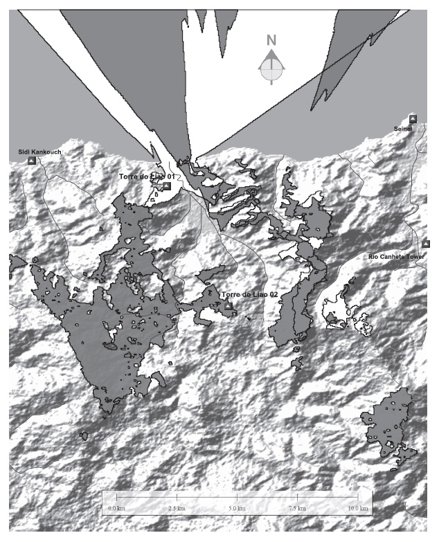
The closest match for Targha, 75 km north-west from the Rif, features in Portuguese and Spanish historical sources as Torres do Lião (Towers of âLionâ â not the animal but the local wadi stream).21 Like nearby sites, the Torres lacked
Overlapping comparative viewsheds calculated respectively from the Torres do Lião 01 site (coastal, white shading) and the Torres do Lião 02 site (inland, dark shading). To the west, the inland site viewshed very nearly met and intermeshed with viewsheds of the easternmost Tangier area sites
FIGURE BY MARTIN MALCOLM ELBL
4.3
Ksar es-Seghir embodies a more complex scenario. Unfortunately, tangible data at various locations (such as Dar al-Borj) are vanishing. Modern port installations (e.g. the Moroccan navy station at Ksar es-Saghir and the container port at Tangier Mediterranean II) have accelerated this decay. The literature, both
Valleys descending north to Ksar es-Seghir featured refuge sites, isolated towers, and signalling locations.24 The north-facing onesâlying mostly near crest linesâsurveyed the coast and the sea, but all were problematic. The so called Mânar (literally âBeaconâ), a key crest-line location, easily stands out on visual inspection of maps (Figure 17.4). It was useful for monitoring nearby slopes and peaks, plus bits of coastline almost west to Sidi Kankouch,25 but it was blind to all but two other lookout sites. It also could not discern well (or at all, under fog) the Portuguese-held Seinel hill above Ksar es-Seghir. This was a boon for the Portuguese, but viewsheds demonstrate that the Seinel was poorly sited for coastal surveillance or for getting signals eastward to Portuguese Ceuta.
Single-point viewshed from a 3D-modelled top of an earlier Islamic tower (no longer extant) at or near the later Portuguese and subsequently English âPeterborough Towerâ, top of Tangierâs qaá¹£aba/later bastioned citadel. The western approaches are covered superbly, the southern ones less well
FIGURE BY MARTIN MALCOLM ELBL
The main northbound valley sloping toward Ksar as Saghir was beyond the purview of the Mânar, for instance. Other locations were required to watch inland areas more favourable for troop movement. Site-to-site intervisibility was not good, but distances were clearly short enough for messengers on footâeven when steeper slopes are factored into the model. The Portuguese never held the hinterland, and this kept Ksar es-Seghir vulnerableâa factor underpinning its eventual evacuation.
4.4
Marsa Musa was deemed in Arabic sources one of the premium tiny anchorages near Ceuta. It is surprising to find in the sources fewer mentions of watchtowers here than one would expect. The reason was partly the confined bay with rugged hinterland, which was daunting for heavy loads and troops. Balyunash, before A.D. 1415 a luxury satellite of Ceuta, featured private recreational suburban dwelling towers, which were handy as lookouts. Physical traces are nearly gone.26 The towers, when modelled in 3D, easily communicated with each other as well as with Ceuta (namely the Almina peninsula). The same applied to ÄfrÄg (al-Manṣūra), a palatial fortified camp-suburb outside of Ceuta (early A.D. 1300s) that is finely documented, with partly extant walls and towers.27 A surprising new observation is that ÄfrÄg (al-Manṣūra), deemed a key MarÄ«nid tool to keep politically restless Ceuta subdued, had indifferent visual command of the port. Viewsheds (whatever the modelling approach) disclose only command of the sea and of near hinterland slopes. Psychological symbol vs. actual tactical reality?
Within Ceuta, remarkably enough, the visual prominence of fortifications or signal posts on top of dominant landscape features was misleading. The top of Jabal Almina (Almina peninsula), where a never completed Islamic citadel existed prior to 1415, should have been a valuable point for surveillance. This was not so. Almina was mainly useful for watching the Strait of Gibraltar in the north. In the opposite direction, it surveyed the more distant coastline to the south. On a fine day, Almina at best discerned only approaches to the south-trending shore. For the port of Ceuta, its immediate vicinity, and tactical stretches of the north and south shores, a tower within the low neck-of-land town was much more useful. The Torre da MouraâTower of the Moorish Womanâwhich survived into the early 20th century. Part of the old Islamic qaá¹£aba and a tool of inner-town policing already in the A.D. 1200s, the c.19-meter-high structure28 outperformed observers at Jabal Almina.
4.5
The surveillance context in Tangier Bay was more complex still. The hydrography, now vastly altered by modern mega-urban sprawl, was very different.29 More survives, however, of the medieval and early modern walls of Tangier than the 1683â4 demolition by the English might suggest. Security comprised various old stone towers30 plus tiny hilltop posts without fixed installations that are mentioned in Portuguese sources. Relevant literature is large and still growing.31 English rule saw the installation, in 1662 to 1684, of well-documented forward military posts. Virtual archaeology and digital modelling are essential here.32 The main feature of the whole perimeter was its inherent coherency, even if after 1471 it was split into European and Moroccan zones. From the peak of the qaá¹£abaâIslamic, Portuguese, reused by the Englishâmost of the other six or seven relevant towers and lookouts were clearly seen (Figure 17.5). The view out to sea, well across the Strait of Gibraltar, was all-encompassing. Former lookouts have now mostly disappeared, or linger only in topographic terms, or in the form of much later installations (e.g. the Cape Malabata lighthouse).33 The old qaá¹£aba of Tangier (a bastioned fortress from the A.D. 1560s onward),34 plus posts around the bay, visually commanded with a single exception practically all the approaches.
Comparative viewsheds calculated respectively from the Torre da Moura (no longer extant) in Ceuta (dark shading) and the Mânar site at Ksar es-Seghir (white shading)
FIGURE BY MARTIN MALCOLM ELBL
4.6
For reasons of length, the present article omits a viewshed analysis of the qaá¹£aba of Tetouan and its sector. Returning to the Atlantic coast in the west, it is worth considering lookouts at Portuguese-controlled Asilah, after 1471. Locations can be reconstructed from chronicles, letters, and toponyms lingering in later colonial maps and field notes.35 Even on this flat coast, the Fachoâidentified by the sources as a key lookout monitoring the approach of enemiesâdid in fact little or nothing for defence, at least as would appear from viewshed analysis (Figure 17.6). At best it covered, counter-intuitively, not the hinterland but the open sea. In the opposite direction, facing inland, a sentry posted at the Facho saw genuinely little, unless opponents were already nearâonly perhaps high columns of dust from advancing infantry and cavalry. This was so even if the sentry, on the Fachoâs c.9 m high platform, climbed further to the very top of the mast equipped with a basketâa fachoâthat could
Comparative viewsheds calculated respectively from the Facho at Asilah (no longer extant, modelled as 9 m high) (light shading) and, cumulatively (dark shading), the Atalaya do Corvo lookout (north) and Atalaya Ruiva lookout (south)
FIGURE BY MARTIN MALCOLM ELBL
Asilahâs northern lookout postsâBugana, Corvo, Outeiro (i.e. âhillockâ) of Fernão da Silva, gave timely warning only with regard to the river bend immediately to the north-east of town. They could see some of the distant inland mountain peaks, but that information was nearly worthless. The lead time they offered for mustering defence within town was minimal. With an enemy moving at top speed, this bought at best only a dozen precious minutes or so.
5 Conclusions
The documented existence of some 55 historic sites, plus those very obliquely mentioned in fragmentary Arabic sources, suggests a higher local density of tower/beacon installations (not all in use simultaneously) than strictly necessary for a beacon system such as that attested by Ibn MarzÅ«q. This surely represents an intersection of different local and micro-regional warning systems that served variable and conflicting needs at different times. As records relating to Tangier Bay, Ceuta, and Asilah confirm, both on the European andâmuch less explicitlyâthe Islamic side, most lookouts were staffed only during crises. Portuguese and Spanish enclaves all scaled down their active lookouts in âpeacetimeâ. There is no reason to believe that Muslim counterparts did anything else. No formal lookout legislation or corresponding mustering requirements have been uncovered. A lookout mechanism was activated only once information obtained by other meansâespionage, merchant gossip, or outright rumoursâsuggested that substantial forces were active in the field or at sea. By far not all parts of these lookout systems served adequately either the goals of dynasties with centralizing ambitions, or of regional commanders and adventurers, or of European enclave holders, even at the height of their respective power and territorial influence. The Ibn MarzÅ«q coherent array of beacons that presumably functioned across North Africa for a limited time from A.D. 1337 (A.H. 737) to A.D. c.1348/A.H. 749) thus represented a peak of what was achievable at the time, as long as a single ambitious dynasty marshalled socio-economic resources and commanded the effective loyalty of local lookout squads.
Bibliography
Primary Sources
Ibn KhaldÅ«n, WalÄ« al-DÄ«n âAbd al-RaḥmÄn. KitÄb al-âibar wa-dÄ«wÄn al-mubtadaâ wa-l-khabar fÄ« ayyÄm al-âArab wa-l-âAjam wa-l-Barbar (1375â1406), trans. Mac Guckin de Slane. Histoire des Berbères et des dynasties musulmanes de lâAfrique septentrionale. 4 vols. Algiers: Imprimerie du Gouvernement, 1852â6.
Ibn MarzÅ«q, AbÅ« âAbd AllÄh Muḥammad al-âAjÄ«sÄ« al-TilimsÄnÄ«. al-Musnad al-á¹£aḥīḥ al-ḥasan fÄ« maâÄthir mawlÄnÄ AbÄ« Ḥasan (1371). MS, Biblioteca del Escorial, no. 1.666, trans. MarÃa Jesús Viguera Molins. El Musnad: hechos memorables de AbÅ« lâḤasan, sultán de los benimerines. Madrid: Instituto Hispano-Ãrabe de Cultura, 1977.
Menezes, Dom Fernando de (2nd Count of Ericeira). Historia de Tanger, que comprehende as noticias desde a sua primeira conquista até a sua ruina. Lisbon: Officina Ferreiriana, 1732 and Tangier: Tipografia Hispano-Arábica de la Misión Católica, 1940.
Secondary Sources
Bazzana, André, Patrice Cressier, and Abd el-Aziz Touri. âArchéologie et peuplement: les mutations médiévales, le cas de Targha.â In Jbala. Histoire et société. Ãtudes sur le Maroc du Nord-Ouest, eds. Ahmed Zouggari, and Jawhar Vignet-Zunz, 307â29. Paris-Casablanca: CNRS-Wallad, 1991.
Boato, Anna, Giampiero Lombardini, and Rita Vecchiatini. âThe Integrated Coastal Defence System in Eastern Liguria in the 15th and 16th Centuries. Verification of Historical Spatial Location Strategies through GIS.â Paper presented at âRIPAM 2017: Conservation et valorisation du patrimoine architectural et paysager des sites côtiers méditerranéens, Genoa, 20â22 Sep. 2017â.
Braga da Cruz, João Sérgio Sequeira Rodrigues. O castelo português de Alcácer Ceguer: transformações morfológicas nos sécs. XV e XVI. 2 vols. Masterâs thesis. Universidade do Minho: Escola de Arquitectura, 2015.
Cámara Muñoz, Alicia. âLos guardianos de la mar: fortificaciones, torres y atalayas en la costa Valenciana (s. XVI).â In Jornadas del bicentenario â Torrevieja 1803â2003, ed. José Fernando Vera Rebollo, 201â19. Alicante: Universidad de Alicante, 2005.
Conolly, James, and Mark Lake. Geographic Information Systems in Archaeology. Cambridge: Cambridge University Press, 2006.
Cravioto, Carlos Gozalbes. âEl otro lado de la frontera: las fortificaciones costeras de la orilla africana del Estrecho de Gibraltar.â In IV Congreso Internacional: las fortificaciones y el mar (Alcalá de Guadaira 2008), ed. Ayuntamiento de Alcalá de GuadaÃra, 19â32. Alcalá de Guadaira: Ayuntamiento, 2008.
Cravioto, Carlos Gozalbes. âArqueologÃa de la frontera norteafricana del Estrecho de Gibraltar (siglos XIVâXVI).â Almoraima 42 (2011): 549â90.
Cressier, Patrice. âFortifications du Rif.â In Castrum I: Habitats fortifiés et organisation de lâespace en Méditerranée médiévale â Table ronde tenue à Lyon les 4 et 5 mai 1982, 45â55. Lyon: Maison de lâOrient et de la Méditerranée Jean Pouilloux, 1983.
Cressier, Patrice. âVille médiévale au Maghreb. Recherches archéologiques.â In Histoire et archéologie de lâoccident musulman (VIIeâXVe siècle): al-Andalus, Maghreb, Sicile, ed. Philippe Sénac, 117â40. Toulouse: Université Toulouse II â Le Mirail, 2012.
Elbl, Martin Malcolm. âThe Master-builder, the Bureaucrat, and the Practical Soldier: Protecting Alcácer Seguer/Qaá¹£r al-SaghÄ«r (Morocco) in the Early Sixteenth Century.â Portuguese Studies Review, 12, no. 1 (2004â2005): 33â73.
Elbl, Martin Malcolm. Portuguese Tangier (1471â1662): Colonial Urban Fabric as Cross-cultural Skeleton. Peterborough and Toronto: Baywolf Press, 2013.
Elbl, Martin Malcolm. âTangierâs Domus Praefecti (Governorâs House) and Ceutaâs Paços Reais/Paço Velho (Palacio Viejo): 3D-modelling Vanished Prestige Dwellings and Cross-cultural Symbols of Governance.â In Encounters in Borderlands: Portugal, Ceuta, and the âOther Shoreâ, ed. Martin Malcolm Elbl, 177â242. Portuguese Studies Review Edited Volumes Series, no. 2. Peterborough and Toronto: Baywolf Press, 2019.
Elbl, Martin Malcolm. âKeys to the Strait: Fortifications in the Strait of Gibraltar from AbÅ« YaâqÅ«b YÅ«suf to AbÅ« al-Ḥasan âAlÄ«.â In Ports and Fortifications in the Muslim World: Coastal Military Architecture from the Arab Conquest to the Ottoman Period, ed. Stéphane Pradines, 7â52. Fouilles de lâIfao 85â2020. Cairo: IFAO, 2020.
Howey, Meghan C.L., and Marieka Brower Burg. âAssessing the State of Archaeological GIS Research: Unbinding Analyses of Past Landscapes.â Journal of Archaeological Science 84 (2017): 1â9.
Jover Maestre, Francisco Javier, and José Luis Menéndez Fueyo. âTorres almenaras para la defensa de la costa (Elche y Santa Pola, Bajo Vinalopó).â In Castillos y torres en el Vinalopó, eds. Gabriel Segura Herrero, and José Luis Simón, 199â210. GarcÃa Alicante: Centre dâEstudis Locals del Vinalopó, 2001.
MartÃnez López, José Antonio, Mansour Akrache, and Larbi El-Mesbahi. Fortificaciones en el norte de Marruecos: Tánger-Tetuán. Murcia: Comunidad Autónoma de la Región de Murcia, 2005.
Matos Carvalho, Cândida Sofia de. O âCastelo de Cimaâ de Tânger entre quatrocentos e seiscentos: de paço a cidadela. Masterâs thesis. Universidade do Minho: Escola de Arquitectura, 2018.
Pedregosa MegÃas, Rafael J., and Juan Miguel Rivera Groennou. âTécnicas constructivas en las torres-atalayas de Montefrio (Granada): La Torre de Las Cabrerizas.â ArqueologÃa y Territorio Medieval 21 (2014): 155â75.
Peixoto, Indira Martins. As arquiteturas militares de Arzile ao tempo português: análise e interpretação evolutiva. 2 vols. Materâs thesis. Universidade do Minho: Escola de Arquitetura, 2017.
Rippon, Stephen J. Historic Landscape Analysis: Deciphering the Countryside. York: Council for British Archaeology, 2004.
Rocha Mendes, Ana Carolina. O Castelo Novo de Tânger: resgate da arquitetura militar portuguesa entre os séculos XV e XVII. Masterâs thesis. Universidade do Minho: Escola de Arquitetura, 2017.
Verhagen, Philip, Laure Nuninger, and Mark R. Groenhuijzen. âModelling of Pathways and Movement Networks in Archaeology: An Overview of Current Approaches.â In Finding the Limits of the Limes: Modelling Demography, Economy and Transport on the Edge of the Roman Empire, eds. Philip Verhagen, Jamie Joyce, and Mark R. Groenhuijzen, 217â49. Cham: Springer, 2019.
Villada Paredes, Fernando, and Pedro Gurriarán Daza, eds. Al-Manṣūra. La ciudad olvidada. Ceuta: Servicio de Museos, 2013.
For a few examples, in diverse technical contexts â coastal as well as those of inland frontiers (e.g. Granada), see Francisco Javier Jover Maestre and José Luis Menéndez Fueyo, âTorres almenaras para la defensa de la costa (Elche y Santa Pola, Bajo Vinalopó),â in Castillos y torres en el Vinalopó, eds. Gabriel Segura Herrero and José Luis Simón GarcÃa (Alicante: Centre dâEstudis Locals del Vinalopó, 2001), pp. 199â210; Alicia Cámara Muñoz, âLos guardianes del mar: fortificaciones, torres y atalayas en la costa Valenciana (s. XVI),â in Jornadas del bicentenario â Torrevieja 1803â2003, eds. José Fernando Vera Rebollo (Alicante: Universidad de Alicante, 2005), pp. 201â19; Carlos Gozalbes Cravioto, âEl otro lado de la frontera: las fortificaciones costeras de la orilla africana del Estrecho de Gibraltar,â in IV Congreso Internacional: las fortificaciones y el mar (Alcalá de Guadaira 2008), ed. Ayuntamiento de Alcalá de GuadaÃra (Alcalá de Guadaira: Ayuntamiento, 2008), pp. 19â32; Rafael J. Pedregosa MegÃas and Juan Miguel Rivera Groennou, âTécnicas constructivas en las torres â atalayas de Montefrio (Granada): La Torre de Las Cabrerizas,â ArqueologÃa y Territorio Medieval 21 (2014), pp. 155â76; Anna Boato, Giampiero Lombardini and Rita Vecchiatini, âThe Integrated Coastal Defence System in Eastern Liguria in the 15th and 16th Centuries. Verification of Historical Spatial Location Strategies through GIS,â paper presented at âRIPAM 2017: Conservation et valorisation du patrimoine architectural et paysager des sites côtiers méditerranéens, Genoa, 20â22 Sep. 2017â.
For technical context, e.g. Stephen J. Rippon, Historic Landscape Analysis: Deciphering the Countryside (York: Council for British Archaeology, 2004); James Conolly and Mark Lake, Geographic Information Systems in Archaeology (Cambridge: Cambridge University Press, 2006); Meghan C.L. Howey and Marieka Brouwer Burg, âAssessing the State of Archaeological GIS Research: Unbinding Analyses of Past Landscapes,â Journal of Archaeological Science 84 (2017), pp. 1â9; Philip Verhagen, Laure Nuninger and Mark R. Groenhuijzen, âModelling of Pathways and Movement Networks in Archaeology: An Overview of Current Approaches,â in Finding the Limits of the Limes: Modelling Demography, Economy and Transport on the Edge of the Roman Empire, eds. Philip Verhagen, Jamie Joyce and Mark R. Groenhuijzen (Cham: Springer, 2019), pp. 217â49.
AbÅ« âAbd AllÄh Muḥammad Ibn MarzÅ«q al-TilimsÄnÄ«, al-Musnad al-á¹£aḥīḥ al-ḥasan fÄ« maâÄṯir mawlÄnÄ AbÄ« Ḥasan, trans. MarÃa Jesús Viguera Molins, El Musnad: hechos memorables de AbÅ« lâḤasan, sultán de los benimerines (Madrid: Instituto Hispano-Ãrabe de Cultura, 1977), pp. 329â30 (Cap. 39) (for practical reasons all references here are to the Viguera version, which is commonly available to all interested non-Arabists); Martin Malcolm Elbl, âKeys to the Strait: Fortifications in the Strait of Gibraltar from AbÅ« YaâqÅ«b YÅ«suf to AbÅ« al-Ḥasan âAlÄ«,â in Ports and Fortifications in the Muslim World: Coastal Military Architecture from the Arab Conquest to the Ottoman Period, ed. Stéphane Pradines, (Fouilles de lâIfao) 85 â 2020 (Cairo: IFAO, 2020), pp. 33â34.
Elbl, âKeys to the Strait,â p. 34, with discussion of further sources.
Ibn Marzūq, al-Musnad (Viguera trans.), p. 330.
WalÄ« al-DÄ«n âAbd al-RaḥmÄn Ibn KhaldÅ«n, KitÄb al-âibar wa-dÄ«wÄn al-mubtadaâ wa-l-khabar fÄ« ayyÄm al-âArab wa-l-âAjam wa-l-Barbar (1375â1406), trans. Mac Guckin de Slane, Histoire des Berbères et des dynasties musulmanes de lâAfrique septentrionale, 4 vols (Algiers: Imprimerie du Gouvernement, 1852â6), vol. 3, p. 410; vol. 4, pp. 220â223. For practical reasons all references here are to the Slane version, which is universally available in digital versions to all interested non-Arabists. De Slane gives 1 May 1337 as date, but 27 Ramaá¸Än 737 A.D. in fact corresponded to 7 May AD 1337.
Ibn KhaldÅ«n, KitÄb al-âibar, 4, pp. 223â25.
Ibn KhaldÅ«n, KitÄb al-âibar, 4, pp. 223â24, plus a very rich secondary literature that far exceeds the purpose of this note.
Ibn KhaldÅ«n, KitÄb al-âibar, 4, p. 234.
Ibn KhaldÅ«n, KitÄb al-âibar, 4, pp. 235â37; Elbl, âKeys to the Strait,â pp. 30â1 and archaeological works listed therein.
Ibn KhaldÅ«n, KitÄb al-âibar, 4, pp. 246â47.
Ibn KhaldÅ«n, KitÄb al-âibar, 4, p. 249.
Ibn KhaldÅ«n, KitÄb al-âibar, 4, pp. 251â52. The Slane translation seems to involve a date conversion error, which has been corrected here.
Ibn KhaldÅ«n, KitÄb al-âibar, 4, pp. 265â66.
Ibn KhaldÅ«n, KitÄb al-âibar, 4, pp. 267â70.
Ibn KhaldÅ«n, KitÄb al-âibar, 4, pp. 276 and 280â81.
Ibn KhaldÅ«n, KitÄb al-âibar, 4, pp. 284â85.
Ibn Marzūq, al-Musnad (Viguera trans.), p. 330. The text asserts that the coastlines remained safe only during the reign of Abū al-Ḥasan and not thereafter.
Rachel Arié, LâEspagne musulmane au temps des Nasrides (1232â1492) (Paris: De Boccard, 1973), pp. 274â75; Elbl, âKeys to the Strait,â p. 33.
André Bazzana, Patrice Cressier and Abd el-Aziz Touri, âArchéologie et peuplement: les mutations médiévales, le cas de Targha,â in Jbala. Histoire et société. Ãtudes sur le Maroc du Nord-Ouest, eds. Ahmed Zouggari and Jawhar Vignet-Zunz (Paris and Casablanca: CNRS and Wallada, 1991), pp. 307â29; José Antonio MartÃnez López, Mansour Akrache and Larbi El-Mesbahi, Fortificaciones en el norte de Marruecos: Tánger-Tetuán (Murcia: Comunidad Autónoma de la Región de Murcia, 2005), pp. 135â56.
See e.g. Carlos Gozalbes Cravioto, âArqueologÃa de la frontera norteafricana del Estrecho de Gibraltar (siglos XIVâXVI),â Almoraima 42 (2011), p. 573. The stream is Oued Liane (aka Oued Alian aka Oued Ilyane). Further, Cláudia Barros, O Olhar de Gomes Eanes de Zurara sobre o Norte de Marrocos: estudo da paisagem de Alcácer Ceguer (Ksar Sghir), Masterâs thesis (Universidade do Minho: Instituto de Ciências Sociais, 2021), pp. 81, 133, 141, 265 and 310â24. The fair number of listed sites in the area ranges all the way from Neolithic to Numidian, Roman, post-Roman, âMedievalâ (a problematic and avoidable concept in Islamic settings), and Early Modern or later.
Martin Malcolm Elbl, âThe Master-builder, the Bureaucrat, and the Practical Soldier: Protecting Alcácer Seguer/Qaá¹£r al-SaghÄ«r (Morocco) in the Early Sixteenth Century,â Portuguese Studies Review 12, no. 1 (2004â5), pp. 33â73; João Sérgio Sequeira Rodrigues Braga da Cruz, O castelo português de Alcácer Ceguer: transformações morfológicas nos sécs. XV e XVI, 2 vols., Masterâs thesis (Universidade do Minho: Escola de Arquitectura, 2015); Elbl, âKeys to the Strait,â pp. 13â16; Cláudia Barros, O Olhar de Gomes Eanes de Zurara sobre o Norte de Marrocos, with ample additional bibliography. The Barros thesis unfortunately does not offer viewshed analyses for any of the listed field-walked sites.
Elbl, âKeys to the Strait,â p. 16.
Gozalbes Cravioto, âArqueologÃa de la frontera,â pp. 574â78.
Gozalbes Cravioto, âArqueologÃa de la frontera,â p. 572.
Patrice Cressier, âVille médiévale au Maghreb. Recherches archéologiques,â in Histoire et archéologie de lâoccident musulman (VIIeâXVe siècle): al-Andalus, Maghreb, Sicile, ed. Philippe Sénac (Toulouse: Université Toulouse II â Le Mirail, 2012), p. 123; a decade of archaeological data remains largely unpublished.
See e.g. Fernando Villada Paredes and Pedro Gurriarán Daza, eds., Al-Manṣūra. La ciudad olvidada (Ceuta: Servicio de Museos, 2013).
Martin Malcolm Elbl, âTangierâs Domus Praefecti (Governorâs House) and Ceutaâs Paços Reais/Paço Velho (Palacio Viejo): 3D-Modelling Vanished Prestige Dwellings and Cross-cultural Symbols of Governance,â in Martin Malcolm Elbl, ed., Encounters in Borderlands: Portugal, Ceuta, and the âOther Shore (Portuguese Studies Review Edited Volumes Series) 2 (Peterborough/Toronto: Baywolf Press, 2019), pp. 221â29.
For synopsis and analysis of sources see e.g. Martin Malcolm Elbl, Portuguese Tangier (1471â1662): Colonial Urban Fabric as Cross-cultural Skeleton (Peterborough/Toronto: Baywolf Press, 2013), passim; Elbl, âKeys to the Strait,â pp. 17â21 (based on Arabic and European sources plus GIS plus secondary literature and field surveys). Extensive references are available therein, including e.g. the standard Dom Fernando de Menezes (2nd Count of Ericeira) [1614â99], Historia de Tanger, que comprehende as noticias desde a sua primeira conquista até a sua ruina (Lisbon: Officina Ferreiriana, 1732; Tangier: Tipografia Hispano-Arábica de la Misión Católica 1940).
E.g. the Gandouri tower; Gozalbes Cravioto, âArqueologÃa de la frontera,â pp. 568â70.
For further references, see e.g. Elbl, Portuguese Tangier; Ana Carolina Rocha Mendes, O Castelo Novo de Tânger: Resgate da arquitectura militar portuguesa entre os séculos XV e XVII, Masterâs thesis (Escola de Arquitectura, Universidade do Minho, 2017); and the essential Cândida Sofia de Matos Carvalho, O Castelo de Cima de Tânger entre Quatrocentos e Seiscentos: de Paço a Cidadela, Masterâs thesis (Escola de Arquitectura, Universidade do Minho, 2018).
Elbl, Portuguese Tangier; for further examples and results of this approach see Matos Carvalho, O Castelo de Cima de Tânger; Elbl, âTangierâs Domus Praefecti (Governorâs House)â.
Gozalbes Cravioto, âArqueologÃa de la frontera,â pp. 568â70. For further topographic and hydrographic context see Elbl, âKeys to the Strait,â p. 17.
Elbl, Portuguese Tangier, pp. 637â760; Elbl, âTangierâs Domus Praefecti (Governorâs House)â; Matos Carvalho, O Castelo de Cima de Tânger.
For a very brief introduction see MartÃnez López et al., eds., Fortificaciones, pp. 237â66; for further data, Indira Martins Peixoto, As arquiteturas militares de Arzile ao tempo português: análise e interpretação evolutiva, 2 vols., Masterâs thesis (Universidade do Minho: Escola de Arquitetura, 2017).