Abstract
In this article I examine the presence of the toponym YaÊ¿qobʾel within its geographical context in the topographical lists of Thutmose III, Ramesses II, and Ramesses III. Historically, YaÊ¿qobʾel and the toponyms clustered with it are located by scholars in Syria. However, it is possible that YaÊ¿qobʾel within Thutmose IIIâs list is found to the south of Moab. The topographical lists of Ramesses II and Ramesses III mention place names that might be linked to YaÊ¿qobʾel, and should be located in southern Transjordan, where the Edomite deity Qaus was worshiped.
1 The Verb ê¥qb and the Name YaÊ¿qob+Divine Name in the Second Millennium BCE
The name YaÊ¿qobʾel is in the Yaqtul preterite conjugation. The first element is the third person masculine Semitic prefix Y. The verb ê¥qb is attested in most Semitic languages, and probably means âto protectâ or âto followâ.1 In the following paragraph, I will present the instances of personal names containing the verb ê¥qb during the second millennium BCE.
Numerous royal scarabs bearing the hieroglyphic inscription of the Hyksos king Yê¥qbhr have been discovered.2 The final element hr is understood by some scholars as
2 YaÊ¿qobʾel (Y-ê¥-ḳ-b-iê¢-r) in Egyptian Topographical Lists of Thutmose III
The toponym Y-ê¤-ḳ-b-iê¢-r is mentioned several times in Egyptian topographical lists from the New Kingdom.10 The earliest attestation is found in the topographical lists of Thutmose III. Three versions of this list exist. In two of these lists (Ia and b) the name has been preserved, whereas in list Ic the name did not survive.11 In list Ia toponym 102 is written 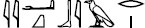 ,12 whereas in the inferior Ib list, toponym 102 has been erroneously transcribed with the sign G17
  (with the phonetic value m) instead of G1
  .13 The sign
  is interpreted as the Semitic prefix Y. The signs
  convey the stem ê¤-q-b. The sign group
  is used to transliterate Semitic âaleph, followed by
  r for /l/. Together, the signs
  are interpreted as the phonetic representation of the divine name âEl.14 Therefore, the name Yê¤á¸³biê¢r is understood as YaÊ¿qobâel.
The precise nature of the list is a subject of debate. Noth15 followed by Alt16 and Helck17 believed the list represented a route of the Egyptian army and its accompanying units dispatched in parallel with the main force. They suggested that these towns were captured and possibly even destroyed during the campaign, based on records from the armyâs âday-booksâ. On the other hand, Yeivin18 and Aharoni19 interpreted the list as delineating political or administrative districts within Canaan. Redford proposed that the topographical list of Thutmose III is composed of itineraries.20
The toponym Yaʿqobʾel is positioned after a series of toponyms (numbers 89 to 101), for which scholars do not concur on their location. Locations for these toponyms to be situated in Judah, Galilee, Bashan and Transjordan have been suggested.21
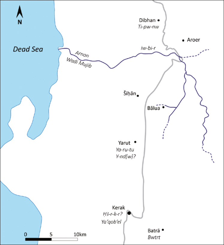
The exact location of the toponym YaÊ¿qobʾel (I 102) remains unidentified. A northern location was favored by the majority of scholars, given its positioning after Ḥê¢-r-kê¢-r (I 101), a toponym that some scholars suggested might have been situated in the Bashan or southern Lebanon. Naʾaman places Ḥê¢-r-kê¢-r at el-Leja, some 30â40 km east Tell-eÅ¡-Å ihab, identified by him as Yenoam. He associates the toponym with Neo-Assyrian Hukkuruna.22 However, the identification of Ḥê¢-r-kê¢-r with Ḫukkuruna should be discarded, as proposed by Redford.23 One of the segments of these itineraries includes the group of toponyms from 89 to 101. Redford situated this itinerary in Transjordan along the kingâs highway stretching from Damascus to Kerak in southern Moab.24 Notable among these toponyms are No. 91 Utraâa, widely identified with the Transjordanian Edrei, modern DerÊ¿a, situated on the Syrian border with Jordan; No. 98 Tpn, which Redford associated with Dibon;25 No. 100, Yarutu, placed in Yarut within Transjordanian Moab;26 and no. 101 Ḥê¢-r-kê¢-r. Following directly after toponym 101 Ḥê¢-r-kê¢-r, YaÊ¿qobʾel is positioned. In a footnote, Redford tentatively and cautiously placed no. 102 âin the region of the Ghor or Lisan, marking the descent of the plateau route towards the Arabah and Egypt.â27 Scholars like Kafafi,28 Worschech,29 and Kitchen30 generally accept Redfordâs suggestion with certain reservations, corrections, updates and additional identifications.31

Possible itinerary of Thutmosis III
Citation: Journal of Egyptian History 17, 1 (2024) ; 10.1163/18741665-bja10027
Others argue that Redfordâs proposal that place-names from 89 to 101 represent an itinerary through Transjordan is, at best, questionable. According to these scholars, Redfordâs suggested identifications are mostly speculative, and many are problematic.32 However, these critics have not put forward alternative suggestions themselves. In our view, the likelihood of YaÊ¿qobʾel being situated to the south of Moab remains quite strong, pending any evidence to the contrary. In the following section I will discuss the potential mention of the toponym YaÊ¿qobʾel in two Ramesside topographical lists.
3 Yaʿqobʾel(?) in Ramesside Topographical Lists
Scholars have identified two additional occurrences of a toponym that they associate with Yaʿqobʾel. The first instance is found in a topographical list of Ramesses II at Karnak, situated on the left (west) side of the entrance to the hypostyle hall.
In the topographical list XXIII, 9 of Ramesses II, the name is inscribed as Yê¥qb<ê¢>lw 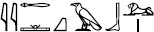 .33 The initial signs represent the prefix y of the verb in the yaqtul form. The signs
  correspond to a phonetic representation of the West Semitic stem ê¥qb. Notably, the orthography differs from the writing seen in the lists of Thutmose III or from the Middle Kingdom.34 The last sign in the toponym is
  (E23) vocalized as /r/ or /l/.35
The name reappears in a topographical list of Ramesses III from Medinet Habu in a cluster of toponyms (XXVII 98â110) that can be located in Canaan, the BaqÊ¿ah Valley, and Central Syria. These toponyms were not originally part of the list of Ramesses III but were copied from the list of Ramesses II at Western Karnak, albeit in an inverted order. Toponyms 110â122 in List XXVII may have been copied from List XXIII. However, since toponyms 34â49 in List XXII are almost entirely destroyed, the origin of toponyms 110â122 cannot be verified with certainty.36
At Medinet Habu the name is defectively inscribed as y-ê¤-<ḳ>-b<ê¢>-l-w  .37 Notably, the q
  sign (N29) is omitted, and the b is represented using
  (R7), while
  (G29) is assigned the phonetic value bê¢. Additionally, the name is accompanied by the classifier of foreign lands
  (N25). In all occurrences of Semitic verbal names with the consonants ê¥qb, none featured an additional consonant r(w).38 This indicates that the final sign belongs to a distinct word. Following the pattern of Semitic names, where the name forms a verbal sentence, the last sign in the toponym YaÊ¿qob-X, functioning as the subject of the sentence, could potentially be a divine name.
Toponyms in List XXVII of Ramesses III copied from List XXIII of Ramesses II
Citation: Journal of Egyptian History 17, 1 (2024) ; 10.1163/18741665-bja10027
The theophoric element of the name âEl, is frequently written as  (as mentioned earlier). Another possible presentation of the writing of the DN âElâ could be
  ,39 and recently the writing ir
  has also been suggested,40 though not without reservations.41 The occurrence of *âEl being written with the signs
  is found several times in the topographical list of Shoshenq I at Pnuâel,42âElgad,43 and potentially âElr[oâi].44
Consequently, the expectation is for the divine name to be present at the end of the toponym, and the sign (E23) could be interpreted as the theophoric element, with an omitted ʾaleph.45 Where should this toponym be located?
4 A Northern Location of Yacob-El (Yê¥qb<ê¢>lw) in the Ramesside Topographical Lists?
The list of Ramesses II (Simons, Handbook, XXIII) comprises of 50 names distributed across seven rows of name-rings, each topped with a bearded Semitic figure. The top four rows, each containing three name-rings, are presented to the king by Amon, the fourth and fifth row, each comprising six name-rings, are introduced by the god Sopdu. Positioned beneath and spanning the entire width of the relief, the seventh row contains 25 name-rings: eight with left-to-right writing, corresponding to the upper lines (26â33) and bearing a clear connection to them; and 17 name-rings facing right, written from right to left.
Above this row lies a horizontal text band with the listâs title. Many of the toponyms in the lowest (7th) row are significantly damaged and are inscribed as palimpsest over earlier reliefs of the battle of Qadesh.46
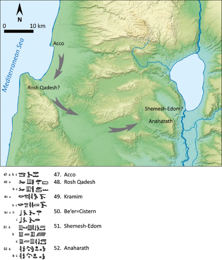
The toponyms numbered 1â4 in the two upper registers were initially thought to be in northern Syria and served as reference point for locating the rest of the toponyms in the list. Rw-Å¡ê¢ Q-d-Å¡ Rqsh Qadesh (Simons, Handbook, XXIII 1)47 was initially believed to be situated in the latitude of Qadesh, potentially Ras esh-Shaqqa, around 25 km south of Tripoli on the Mediterranean coast.48 However, in Thutmose IIIâs topographical list, Rosh Qadesh (Simons, Handbook, I 48) appears following Acco (Simons, Handbook, I 47).49 Toponym I 49 K-r-ym-nê¢ Kramim should be translated as Vineyards, which were grown in the fertile plain, and toponym I 50 B-ê¢-ê¢-r Beʾer probably mentioned a cistern. The next Toponym ((Simons, Handbook, I 51) is Å¡ê¢-m-Å¡ê¢ I-t-m Shemesh-Edom.50 The subsequent located toponym is I-nw-ḥ-r-t-w Anaḥarath (Simons, Handbook, I 50; Tel Rechesh in Naḥal Tavor),51 which is linked to the inheritance of the tribe of Issachar (Josh. 19:19). As a result, several scholars identify Rosh Qadesh at Ras-en-Naqurrah or more fittingly, the Carmel mountain.52
Citation: Journal of Egyptian History 17, 1 (2024) ; 10.1163/18741665-bja10027
The remaining toponyms were generally situated in the vicinity of Byblos and Tripoli, mainly to the east of el-BatrÅ«n and ṬarÄblus in northern Lebanon.53 Curiously, the primary toponym in the region, Qadesh, is not referenced in the list, nor in any of Ramesses IIâs other topographical lists.54 None of the toponyms can be confidently pinpointed, as all identifications are based on similarities to modern place names,55 and there is no geographical sequence between the listed toponyms.
For instance, ê¤-n n-g-r (Simons, Handbook, XXIII 3/ XXVII 110), was initially associated with modern Anjjar, located 20 km NNW of Kamid el-Loz in the Beqaʾ Valley due to phonetic resemblance.56 However, the meaning of the term is simply âflowing57 spring,â which could apply to various locations (see below).58
Rê¢-ḥ-á¸ê¢ (Simons, Handbook, XXIII 4) is often linked to Ruḫizzi in the Middle Orontes Valley,59 leading to the positioning of the other toponyms in proximity. Nonetheless, this identification is far from certain, given the distinct spellings of rw-g-á¸ê¢  Ruḫizzi (reflecting an original Ä¡)60 and rê¢-ḥ-á¸ê¢
 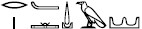 , which may originate from rḥs, meaning âwashâ.61 These four toponyms donât inherently indicate northern Lebanon or Syria.
Helck, following Noth, identified Simons, Handbook, XXIII 9, YaÊ¿qubr/lu with a place named âMeqa beraâ located eight km northeast of Krak des Chevaliers (modern QalÊ¿at el-Husn). This interpretation implies adding the letter m at the nameâs beginning and a metathesis of the q and the Ê¿ayin.62
Postulated toponyms in Northern Lebanon
Citation: Journal of Egyptian History 17, 1 (2024) ; 10.1163/18741665-bja10027
No. 10, K-ê¢-r-k-ê¢, was initially linked with âKrak des Chevaliersâ.63 However, if the toponym is to be associated with a Crusaders-era location, could Medieval Kerak in southern Moab (140 km south of Amman) also be a potential option?64 It is important to note, that neither Krak des Chevaliers nor Kerak can demonstrate a continuous history of name and habitation from the Late Bronze Age to the Middle Ages.
The same flawed methodology was repeatedly employed with many of the toponyms found in the topographical lists. This approach was based solely on name resemblance, without considering whether there exists archaeological continuity at the proposed site, or continuity of name between the toponyms from the Late Bronze Age and modern times. A majority of these toponyms are not mentioned in other Egyptian topographical lists, and cannot be accurately situated.65 Additionally, prominent city-states, where Ramesses II campaigned during his fourth, fifth, and eighth regnal years are absent, including Sidon, Beirut, Byblos, Amurru Batruna, Dapur, Halba, Ullasa, ʾArdata, ʿIrqata, Ṣumur, Tunip, Takhshi, Shabtuna, Arnam [Hermel], Labuʾe, Qadesh, among others.66 As a result, there is little justification to place Yaʿqobʾel in northern Lebanon. This leads to the question: where could Yaʿqobʾel potentially be located?
5 A Southern Location of YaÊ¿qobâel in the Ramesside Topographical Lists?
In the subsequent section, I will forward a suggestion to locate the following toponyms in List XXIII. Helck situated No. 15, Arduna (Simons, Handbook, XXIII 15) at modern Arde, which is around 10 km east-southeast of Tripoli. However, could it possibly refer to the Jordan River?67 Simple generic terms for geographical features like hr for [mountain]68 were included in topographical lists.
Noth proposed identifying Ḫ-r-ṯ  (Simons, Handbook, XXIII 16) with Haldiye, situated four km south of Arde.69 James suggested that the name might actually reflect the common northwest Semitic term Ḥrṯ meaning âcamp,â âcultivated landâ or
Q-r-ḥ)Simons, Handbook, XXIII 17 (was identified as *Qalhi, located at el-Qalhat, approximately five km east of Enfe.74 Knohl suggested identifying this toponym with the biblical
Toponym Simons, Handbook, XXII 18 is transcribed Tê¢ Kê¢-ti-i ( with N16
  , not with the slightly higher sign iw
  N18, and lacking the signs Z1 and N21). However, in the copied list of Ramesses III (Simons, Handbook, XXVII) the corresponding toponym 98 is written
  Tê¢ Kê¢-sw-i with sw
  M23. Thus, the toponym may be read as Tê¢ Kê¢á¹¯i/Ksw. In this context, one might cautiously propose that the land of Kushu, written with the Egyptian word tê¢ for âLand,â could be equated with Ancient Kushu, likely in Edom.76
Simons, Handbook, XXIII 19 yw-b-r [yuval=river] might refer to a river, possibly one of the of the tributaries flowing into the Jordan River.77 Therefore, it appears that the toponyms Simons, Handbook, XXIII 15â19 could be located at the southern end of Transjordanian Moab or Edom.78 The name Moab also emerges in name rings in the brief topographical lists in the Luxor forecourt, Aksha, Amara West, and Akhmim.79
Toponyms in Transjordan?
Citation: Journal of Egyptian History 17, 1 (2024) ; 10.1163/18741665-bja10027
The toponym Ḥê¢-d-y-sê¢-ti (Simons, Handbook, XXIII 23) was initially placed on the north bank of the Nahr Abu Ali, a few km below Bsharre in northern Lebanon.80 However, the mentioning of [Ḥ]-d-Å¡ê¢-ti in the topographical list of Shoshenq I (Simons, Handbook, XXXIV 54, read by Simons as [Q?]dÅ¡t), after the toponym [P]nuâel, places the toponym in Transjordan, near the Yabok river.81
6 The God Sopdu, Lord of the East, Leading Prisoners
Another indication that the name rings could represent toponyms in Edom is the portrayal of Sopdu, Lord of the East (especially Sinai).82 Sopdu is positioned before the lower name rings, leading them towards the king. The Southern Nubian god Dedwen, Ḥê¢, god of the West, Sopdu, god of the East, Maâat, goddess of justice and cosmic order and Waset, goddess of Thebes are depicted leading name rings on smiting scenes of Egyptian kings such as Thutmose III, Sethi I, Ramesses II and Ramesses III.83 A closer look at the toponyms in proximity to YaÊ¿qobʾel may further contribute to the location of the toponym.
7 Name Rings Containing the Consonants Q-s in the Egyptian Topographical Lists of Ramesses II and Ramesses III
In the topographical list of Ramesses II from Karnak (Simons, Handbook, XXIII), toponyms 7, 8, 13 and 21, along with their corresponding entries copied in the topographical list of Ramesses III at Medinet Habu (Simons, Handbook, XXVII 85, 89, 100, 101, 103), commence with the consonants Q and s.84 Scholars have positioned toponyms 7, 8, 13 and 21 in northern Lebanon. The toponymic prefix q-Å wasnât seen as a common denominator for these places; rather it was treated as a distinct feature in each case. See the suggestions in Kitchen RITANC II, 67â69: No. 7, QasaraÊ¿; No. 8, Qaws/z-Asir; No. 13, Qawsan-rom;85 No. 21, Qasir-Yubuna.86
Location of toponyms in Egyptian Topographic List XXIII of Ramesses II
Citation: Journal of Egyptian History 17, 1 (2024) ; 10.1163/18741665-bja10027
Geographical organization of toponyms from north to south in the list of Ramesses III
Citation: Journal of Egyptian History 17, 1 (2024) ; 10.1163/18741665-bja10027
Moreover, when attempting to locate these toponyms in northern Lebanon, it is important to note that the Egyptian pharaohs, particularly Thutmose III, but also Sethi I, Ramesses II and III, were active in this area. However, no correspondence exists with toponyms from this region (in fact, the presence of toponyms with Q-s in Egyptian topographical lists is exclusive to Lists XXIII and XXVII).
The arrangement of these toponyms based on the geographic order of the list of Ramesses III (Simons, Handbook, XXVII) places them in the southern Levant rather than the north (Simons, Handbook, XXVII 1â69). Notably, the African names are listed at the left end of the name-rings, clearly indicating a south-to-north organization of the toponyms.87
Furthermore, there is no evidence of any settlement commencing with the consonants q-s at the beginning of toponyms in the entire corpus of the Répertoire Géographique des Textes Cunéiformes 1â12, which covers the complete Ancient Near Eastern toponymic corpus from the second to the first millennium.88 Thus, the distribution of these consonants in toponyms is unique and demands an explanation.
Oded proposed that four names, which start with the consonants q and Š(Nos. 7,11,13, 21; also inscribed in a list of Ramesses III at Medinet Habu (Nos. 85, 89, 100, 101, 103) and one starting with the letters q and ṯ (No. 8), might comprise a name incorporating the theophoric Edomite element Qaus
8 Textual Evidence of Military Activity of Ramesses II in Seir/Edom
It should not be surprising that toponyms commencing with consonants q-s may find their origins in Edom. In the lists of Ramesses II from Amarah West, six place-names are prefixed with the term âShasu-land,â with the first being SeÊ¿ir.95 Ramesses II also mentions SeÊ¿ir in other inscriptions.96 For instance, on his obelisk I at Tanis (originally from Pi-Ramesse), he proclaims âFerocious Lion, one who rages, destroying the land of Shasu, Plundering the Mountain of SeÊ¿ir with his valiant armâ.97
On the East-Delta stela Gebel Shaluf II, Ramesses II98 is once again described (on Face A) as one âwho plunders the Mountain of Se[Ê¿ir with his valiant arm],â while the goddess Ê¿Anath pledges on left edge, âI grant to you the land of Shasu for your time (?)â. In the third monument, the rhetorical stela from Tell er-Retaba, sets the Shasu in hilly terrain: âMaking great slaughter in the land of Shasu, he plunders their mountain-ridges, slaying their people, building with settlements (dmiw, with town-determinative) in his name, forever.â99
The connection of the Shasu with mountainous terrain fitting Seʿir/Edom very well, according to Kitchen, was suitable.100 However, Vasiliev has recently demonstrated that the slaying of the Shasu in the stela from Tell er-Retaba did not take place in Edom, but rather on the ṯsw.t sand dunes of the Sinai.101
9 Textual Evidence of Military Activity of Ramesses III in Seir/Edom
Some decades later, in Year 8 of Merenptah in 1206 BCE, âShasu-tribesfolk of Edomâ were allowed into to the East Delta.102 Still later, Ramesses III claims âI destroyed the SeÊ¿irites among the Shasu tribes, I plundered their tents (using West-Semitic word ʾahl)103 of people and goodsâ.104 In the topographical list of Ramesses III from Medinet Habu, the toponyms, probably situated in Edom, are copied from the list of Ramesses II.
10 The War Reliefs on the Southern Outer Wall of the Hypostyle Hall at Karnak
The adjoining war reliefs on the southern outer wall of the hypostyle hall at Karnak portray, on the western side, three registers that showcase Ramesses II engaged in battle against besieged towns. Each register is divided into five scenes. In many of the scenes Ramesses II attacks two cities either from his chariot or on foot. The movement of the Egyptian pharaoh battling against besieged foes unfolds from right to left. At the right extremity of the registers, the Pharaoh leads captives back to Egypt, and presents them before the god Amun. Most of the names of these towns have not survived. The few toponyms that did remain are unidentifiable âon the ground,â and most suggestions are mere conjecture.
In the upper register, the conquest of I-p-q-w Apheq is depicted. However, the specific Apheq in question remains unclear: whether it is Apheq 1 in Lebanon at the Nahr Ibrahim,105 Apheq 2, Tell el-Kabri to the southeast of Acco in the territory of the tribe of Asher (Josh. 19:30),106 Apheq 3 to the East of the Lake Kinneret (2 Kgs 13:14â19), or Apheq 4 (Ras el-Ê¿Ain, Antipatris, Tel Apheq) at the headwaters of the Yarkon River. Despite damage to the reliefâs surface, and the erasure of several enemy heads in later times, the adversaries depicted are typical Canaanites.107 The decision between these various possibilities impacts the interpretation of the scene and determination of the eventsâ location.
The subsequent identifiable town to be attacked is Krmim. This place likely pertained to a location where vineyards were cultivated. It has been associated with el-Qalamun, positioned six km southwest of Tripoli, even though el-Qalamun retains its original q rather than k.108 Krmim is mentioned in the list of Thutmosis I (Simons, Handbook, I 49) immediately following Acco and Rosh Qadesh. Its location is likely in the vicinity of the Carmel Mountain (see above).109 There is a possibility it may have been listed in the topographical list of Ramesses II from Karnak at number 48.  .110
.110
In the middle register, scene c (second from the right), the depiction illustrates the conquest of two cities. The name of the upper city is obliterated and only the final signs [â¦]-r-Ḡ remain discernible.111 The lower town is identified as Mw-ti-i-r Mutir, which is referenced in Simons, Handbook, XX: 20; XXI: 39 and in the Luxor reliefs. The contextual clues within the topographical list suggest a northern location, given the mention of Ullaza, Tyre, Yenoam. Mutir is associated with Mutariye, situated seventeen km east from el-Batrun, (approximately 25 km south from Tripoli, in northern Lebanon).112
Moving to the following scene in the middle register a town named Iṯr  comes under attack. Helck located Iṯr A-s/zi-r/l at Izal, located fifteen km east-southeast of Tripoli.113 The defenders portrayed are typical Canaanites. Notably, the only secure toponym mentioned in the reliefs is ê¤ê¢-k-w Acco, featured in the middle register.114 Acco is depicted in a state of ruin and abandonment, lacking defenders. Since Iṯr and Acco are depicted in close proximity, the suggested location of Iṯr in Lebanon seems too far north.115
The town, depicted in the subsequent relief to the left within the middle register is  Q-ê¢w-ṯ-i-s-r-w. The town is defended by typical Canaanite forces.116 Helck placement of the town in the vicinity of Qadesh on the Orontes is incorrect and stems from a misinterpretation of a palimpsest of the Qadesh inscription.117 This mistake has been rectified by Kitchen,118 who, nevertheless, refrains from specifying an alternative location and suggests a location near the Eleutheros Valley. There is no valid justification for retaining this northern location. Additionally, Kitchen does not elucidate the potential connection between this toponym and the preceding one in the sequence, Acco.
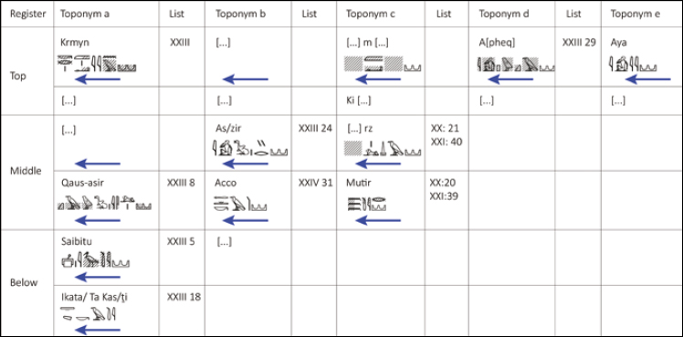
In summarizing the sequence of the identified toponyms in the reliefs and comparing them with the order of the occurrences of the toponyms in the topographical list XXIII, it becomes evident that they are not arranged in a corresponding order. The primary direction of movement in the relief scenes is from right to left. The depiction begins on the right side of the upper register with an unidentified town Aya, and progresses with the siege of Apheq (XXIII 29). Subsequent scenes to the left lack preserved names, and the final scene in the sequence shows the battle against Krmym (probably mentioned in XXIII 48?). Moreover, certain besieged towns do not appear in list XXIII, but rather in distinct topographical lists of Ramesses II.
In the middle register, there is a depiction of a battle against [Ur]za? (XX: 21; XXI: 40, but absent in XXIII). Positioned below [Ur]za, the town of Mutir is portrayed (XX: 20; XXI: 39). Mutir is not mentioned in the readable toponyms of XXIII. The close proximity of [Ur]za and Mutir in the topographical lists XX and XXI, as well as in the reliefs at Karnak and Luxor implies that they were probably situated within the same geographical region.
The scenes of the conquest of Iṯr (XXIII 24) and Acco (not specified in XXIII; however, mentioned in list XXIV 31 of Ramesses II at Karnak, following Pehel, Hamath, Beth-Shean and Yenoam in the Jordan Valley) follow suit.119
The portrayal of the conquest of Qê¢wṯ-isrw positioned at the left end of the register, is recorded in XXIII 8. Should the toponym Qê¢wṯ-isrw indeed be located in Edom, as proposed by Oded, and cautiously acknowledged in this current article, one might anticipate the depiction of the inhabitants as Shasu nomads, characterized with braided hair, rather than as urban Canaanites defending fortified cities.
Toponyms depicted in the war reliefs on the southern outer wall of the Hypostyle Hall at Karnak and the corresponding mention in the topographic lists
Citation: Journal of Egyptian History 17, 1 (2024) ; 10.1163/18741665-bja10027
However, this expectation is not borne out. Throughout the entire wall, the enemy warriors are either illustrated as typical Canaanites with beards and an abundance of hair, or as having a beard while wearing a head cap. (Numerous depictions of warrior heads were deliberately defaced in later periods.)
A similar occurrence can be observed in the Cachette war scenes of Merneptah, where one of the scenes is interpreted as Merneptahâs engagement with Israelites, portrayed as Canaanites outfitted with chariots.120 Hasel proposed the reconstruction of a besieged town at the reliefâs conclusion.121 If his reconstruction is accurate, and the fourth scene in Merneptahâs reliefs at the Cour de la Cachette indeed portrays the conflict with the people of Israel, we encounter the same phenomenon of portraying potential nomads as settled populations. Subsequently, these depictions are juxtaposed with the subsequent scenes that show Shasu nomads being deported to Egypt.
The only surviving names of conquered cities are located on the left side of the scene. The toponyms Saibitu (XXIII 5) and Ta-Kusi/Ikata (XXIII 8; as discussed above) remain unlocated. It appears that the battle scene on this wall was constructed from various topographical lists, rendering it unsuitable for reconstructing the chronological progression of the Egyptian forces in the Levant.
However, not all puzzles have been resolved. The most recent archaeological discoveries in Edom indicate the absence of settlements and monumental structures dating back to the thirteenth and twelfth centuries BCE, and the earliest monumental buildings are dated to the Iron IIa.122 Iron I pottery has been identified at Faynan, although it lacks association with any significant stone-built remains. As a result, the textual and visual representations do not align with the archaeological evidence on the ground.
11 In Conclusion
Yaʿqobʾel, despite the different orthographies, appears in the topographical lists of Thutmose III from Karnak (Simons, Handbook, I, 102), Ramesses II from Karnak (Simons, Handbook, XXIII, 9) and Ramesses III from Medinet Habu (Simons, Handbook, XXVII, 104).
The toponym Yaʿqobʾel was mistakenly located in Northern Lebanon and should be located in Southern Transjordan.
The topographical lists of Ramesses II and III contain several additional toponyms that can be located in Moab and Southern Transjordan.
According to their inscriptions, Ramesses II and Ramesses III campaigned in southern Transjordan against Edom/Seir.
The toponyms in the list of Ramesses II are led by Soped, Lord of the East (and the Sinai Desert).
The geographic arrangement of toponyms in the list of Ramesses III locates Yaʿqobʾel in the Southern Levant.
Names Rings with the consonants Q-s are not recorded in the ANE, but do occur in the Egyptian topographical list of Ramesses II, and may probably be located in Edom.
Therefore, Yaʿqobʾel appears in close proximity to, and even among toponyms that are probably located in Edom.
Acknowledgment
The present article is a rejoinder to Israel Knohl's work, âJacob-el in the Land of Esau and the Roots of Biblical Religionâ (see bibliography). While it addresses and revises certain assumptions put forth by Knohl, it ultimately affirms his central claim that the YaÊ¿qobʾel toponyms should be situated in southern Transjordan.
Abbreviations
| AUSS | Andrews University Seminary Studies |
| BDB | Brown, F., S.R. Driver, and C.A. Briggs. A Hebrew and English Lexicon of the Old Testament. Oxford: Clarendon Press, 1907. |
| NABU | Nouvelles Assyriologiques Brèves et Utilitaires |
| RITA II | Kitchen, K.A. Ramesside Inscriptions. Translated and Annotated Translations, II: Ramesses II, Royal Inscriptions, Oxford: Blackwell, 1996. |
| RITANC II | Kitchen, K.A. Ramesside Inscriptions. Translated and Annotated Translations, II: Ramesses II, Royal Inscriptions. Oxford: Blackwell, 1999. |
| UF | Ugarit Forschungen |
| VT | Vetus Testamentum |
Bibliography
Adrom, F. âIsrael in Berlin? Identifizierungsvorschläge zur Fremdvölkerliste Berlin 21687.â In Geschichte und Gott. XV. Europäischer Kongress für Theologie (14.â18. September 2014 in Berlin), M. Meyer-Blank, ed., 288â301. Berlin: Evangelische Verlagsanstalt, 2016.
Aharoni, Y. The land of the Bible: a historical geography. 2nd ed. Westminster: John Knox Press, 1979.
Aḥituv, S. Canaanite Toponyms in Ancient Egyptian Documents. Leiden: Brill, 1984.
Aḥituv, S. âDid Ramesses II Conquer Dibon?â IEJ 22.2/3 (1972): 141â142.
Albright, W.F. âNorthwest-Semitic Names in a List of Egyptian Slaves from the Eighteenth Century BC.â JAOS 74.4 (1954): 222â233.
Albright, W.F., and T.O. Lambdin. âNew material for the Egyptian Syllabic Orthography.â JSS 2.2 (1957): 113â127.
Alt, A. âDie Landnahme der Israeliten.â In Kleine Schriften zur Geschichte des Volkes Israel, A. Alt, ed., 89â125. München: Beck, 1953.
Ben-Tor, D., S.J. Allen, and J.P. Allen. âSeals and kings.â BASOR 315 (1999): 47â74.
Ben-Tor, D. and R. Bonfil. âThe Scarab of Yaqbhr from Shiqmona Reconsidered.â In Aharon Kempinski Memorial Volume: Studies in Archaeology and Related Disciplines, E.D. Oren and S. Ahituv, eds., 29â55. Beer-Sheva: Studies by the Department of Bible and Ancient Near East 15; Beʾer Sheva: Ben Gurion University of the Negev, 2002.
Ben-Yosef, E. âA False Contrast? On the Possibility of an Early Iron Age Nomadic Monarchy in the Arabah (Early Edom) and its Implications to the Study of Ancient Israel.â In From Nomadism to Monarchy, I. Koch, O. Lipschits, and O. Sergi, eds., 235â262. MOSAICS 3. Univ. Park: Eisenbrauns, 2023.
Brand, P.J. âThe Date of the War Scenes on the South Wall of the Great Hypostyle Hall and the West Wall of the Cour de la Cachette at Karnak and the History of the Late Nineteenth Dynasty.â In Ramesside Studies in Honour of K.A. Kitchen, M. Collier, and S. Snape, eds., 51â84. Bolton: Rutherford, 2011.
Brand, P.J. Ramesses II: Egyptâs Ultimate Pharaoh. Columbus: Lockwood, 2023.
Caminos, R.A. Late-Egyptian Miscellanies. Brown Egyptological Studies 1. London: Oxford University Press, 1954.
Cooper, J. âPunt in the âNorthernâ Topographical Lists.â JEA 104.1 (2018): 93â98.
Cooper, J. Toponymy on the Periphery: Placenames of the Eastern Desert, Red Sea, and South Sinai in Egyptian Documents from the Early Dynastic until the end of the New Kingdom. Pdà 39. Leiden: Brill, 2020.
Danielson, A.J. âOn the History and Evolution of QWS: The Portrait of a First Millennium BCE Deity Explored through Community Identity.â JANER 20.2 (2021): 113â189.
Darnell, J.C. and R. Jasnow. âOn the Moabite Inscriptions of Ramesses II at Luxor Temple.â JNES 52.4 (1993): 263â274.
David, A. and E. Bumann. âMikael and Mikeset in Beth Shean.â JSSEA 42 (2015): 113â123.
Edel, E. and M. Görg, Die Ortsnamenlisten aus dem Totentempel Amenophis III. ÃAT 50. Wiesbaden: Harrassowitz, 2005.
Finkelstein, I. and O. Lipschits. âThe Genesis of Moab: a Proposal.â Levant 43.2 (2011): 139â152.
Fischer-Elfert, H.-W. Die satirische Streitschrift des Papyrus Anastasi I.: Ãbersetzung und Kommentar. ÃA 44. Wiesbaden: Harrassowitz, 1986.
Fuscaldo, P. âAksha (Serra West): el Templo de Ramsés II. I: La Lista Topográfica del Atrio.â REE 1 (1990): 17â46.
Gardiner, A.H. Late-Egyptian Miscellanies. Bibliotheca Aegyptiaca 7. Bruxelles: Fondation egyptologique reine Elisabeth, 1937.
Gelb, I.J. Computer-aided analysis of Amorite. Assyriological Studies 21. Chicago: Oriental Institute of the University of Chicago, 1980.
Gesenius, W. Hebräisches und Aramäisches Handwörterbuch über das Alte Testament. 18th ed. Berlin: Springer, 2005.
Giveon, R. âSoped in Sinai.â In Studien zu Sprache und Religion Ãgyptens. Zu Ehren von Wolfhart Westendorf. Ãberreicht von seinen Freunden and Schülern II: Religion, F. Junge, ed., 777â785. Göttingen: Junge, 1984.
Giveon, R. âYaqob-har.â GM 44 (1981): 17â19.
Golinets, V. Das amurritische Onomastikon der altbabylonischen Zeit. Band 2: Verbalmorphologie des Amurritischen und Glossar der Verbalwurzeln. AOAT 271.2. Münster: Ugarit Verlag, 2018.
Goren, Y., Finkelstein, I. and N. Naʾaman. Inscribed in Clay: Provenance Study of the Amarna Letters and other Ancient Near Eastern texts. Monograph Series 23. Tel Aviv: Emery and Claire Yass Publications in Archaeology, Tel Aviv University, 2004.
Grandet, P. Le Papyrus Harris I (BM 9999). Vol. I. Bdà 109/1. Cairo: IFAO, 1994.
Grandet, P. Le Papyrus Harris I (BM 9999). Vol. II. Bdà 109/2. Cairo: IFAO, 1994.
Haider, P.W. âZum Moab-Feldzug Ramses II.â SaK (1987): 107â123.
Hasel, M.G. âMerneptahâs Inscriptions and Reliefs and the Origins of Israel.â In The Near East in the Southwest: Essays in Honor of William G. Dever, B.A. Nakhai, ed., 19â44. AASOR 58. Boston: American Schools of Oriental Research, 2003.
Hawass, Z. âA New Colossal Seated Statue of Ramses II from Akhmim.â In Timelines: Studies in Honor of Manfred Bietak, Vol. I, E. Czerny, et. al., eds., 129â139. OLA 149. Leuven: Peeters, 2006.
Helck, W. Die Beziehungen Ãgyptens zu Vorderasien im 3. und 2. Jahrtausend v. Chr.: 2. ÃA 5. Wiesbaden: Harrassowitz, 1962.
Hoch, J.E. Semitic Words in Egyptian Texts of the New Kingdom and Third Intermediate Period. Princeton: Princeton University Press, 1994.
Hoftijzer, J. and K. Jongeling. Dictionary of the North-West Semitic Inscriptions. HdO Section I, vol. 21. Leiden: Brill, 1995.
James, P. âThe Levantine War-Records of Ramesses III: Changing Attitudes, Past, Present and Future.â AO 15 (2017): 57â148.
Kafafi, Z.A. âEgyptian Topographical Lists of the Late Bronze Age on Jordan (East Bank).â BN 29 (1985): 17â21.
Kahn, D. âThe Historical Background of a Topographical List of Ramesses III.â In Rich and Great: Studies in Honour of Anthony J. Spalinger on the Occasion of his 70th Feast of Thoth, Renata Landgráfová and Jana MynáÅová, eds., 161â168. Prague: Charles University in Prague, Faculty of Arts, 2016.
Kelley, J. âToward a New Synthesis of the God of Edom and Yahweh.â AO 7 (2009): 255â280.
Kempinski, A. âSome Observations on the Hyksos (XVth) Dynasty and Its Canaanite Origins.â in Pharaonic Egypt: the bible and Christianity, ed. Israelit-Groll S. 129â137. Jerusalem: Magnes Press, 1985:
Kempinski, A. âTwo Scarabs of Yakubum.â In Studies in Egyptology Presented to Miriam Lichtheim, ed. Israelit-Groll, S. 632â634. Jerusalem: Magnes, 1990.
Kitchen, K.A. âThe Egyptian Evidence on Ancient Jordan.â In Early Edom and Moab: The Beginning of the Iron Age in Southern Jordan, P. Bienkowski, ed., 21â34. Sheffield: Archaeological Monographs, 1992.
Kitchen, K.A. âEgyptian New-Kingdom Topographical Lists: An Historical Resource with âLiteraryâ Histories.â In Causing his Name to Live: Studies in Egyptian Epigraphy and History in Memory of William J. Murnane, P.J. Brand and L. Cooper, eds., 129â135. CHANE 37. Leiden, Brill, 2009.
Kitchen, K.A. âMoab in Egyptian and Other Sources: Fact & Fantasy.â GM 212 (2007): 119â128.
Kitchen, K.A. âThe Triple Topographical List of Thutmose III (4.1) (1479â1425 BCE).â In The Context of Scripture Canonical Compositions, Monumental Inscriptions, and Archival Documents from the Biblical World, K. Lawson Younger, ed., 5â11. Leiden: Brill, 2017.
Knauf, E.A. âAbel Keramim.â ZDPV (1984): 119â121.
Knauf, E.A. âQaus in Ãgypten.â GM 73 (1984): 33â36.
Knauf, E.A. âQÈs.â In Dictionary of Deity and Demons in the Bible, K. van der Toorn, B. Becking & P.W. van der Horst, eds., 674â677. Grand Rapids, Eerdmans, 1999.
Knohl, I. âJacob-el in the Land of Esau and the Roots of Biblical Religion.â VT 67.3 (2017): 481â484.
Krahmalkov, C.R. âExodus Itinerary Confirmed by Egyptian Evidence.â BAR 20.5 (1994): 54â62.
Kuschke, A. âBemerkungen zu einer Syrienliste Ramsesâ II.â In Fontes atque Pontes. Eine Festgabe für Hellmut Brunner, M. Görg, ed., 254â270. ÃAT 5. Wiesbaden: Harrassowitz, 1983.
Lenzen, C.J. and E.A. Knauf. âNotes on Syrian Toponyms in Egyptian Sources. I.â GM 96 (1987): 59â64.
Levy, E. âA Fresh Look at the Mekal Stele.â Ã&L 28 (2018): 359â378.
Morschauser, S. âOn the âPlunderâ of Dapur.â BES 7 (1985.): 15â28.
Naʾaman, N. âDid Ramses II Wage Campaign against the Land of Moab.â GM 209 (2006): 63â69.
Naʾaman, N. âThe Hurrians and the end of the Middle Bronze Age in Palestine.â Levant 26.1 (1994): 175â187.
Naʾaman, N. âJacobâs Initiation Story: A Judahite Late-Monarchical Composition.â Semitica 63 (2021): 141â167.
Naʾaman, N. âYenoâam.â TA 4.3â4 (1977): 168â177, with an appendix by R. Zadok, Appendix: on the Toponym Ḥ1/12kr.
Noth, M. âDie Wege der Pharaonenheere in Palästina und Syrien. Untersuchungen zu den hieroglyphischen Listen palästinischer und syrischer Städte.â ZDPV 61 (1938): 26â65.
Oded, B. âEgyptian References to the Edomite Deity Qaus.â AUSS 9.1 (1971): 47â50.
Rainey, A.F. âCan You Name the Panel with the Israelites? Raineyâs Challenge.â BAR 17.6 (1991): 54â60.
Rainey, A.F. âEgyptian Evidence for Semitic Linguistics, Review of Hoch.â In Past Links: Studies in the Languages and Cultures of the Ancient Near East, S. Izreʾel, I. Singer, and R. Zadok, eds., 431â454. IOS 18. Winona Lake, Indiana: Eisenbrauns, 1998.
Rainey, A.F. and R.S. Notley. The Sacred Bridge. Jerusalem: Carta, 2006.
Redford, D.B. âA Bronze Age Itinerary in Transjordan (Nos. 89â101 of Thutmose IIIâs List of Asiatic Toponyms).â JSSEA 12.2 (1982): 55â74.
Redford, D.B. âContact between Egypt and Jordan in the New Kingdom: Some Comments on Sources.â In Studies in the History and Archaeology of Jordan 1, A. Hadidi, ed., 115â119. Amman: Department of Antiquities, Jordan, 1982.
Ritner, R.K. âThe Supposed Earliest Hieroglyphic Mention of Israel (Berlin AM 21687): A Refutation.â In Semitic, Biblical and Jewish Studies in Honor of Richard C. Steiner, A.J. Koller, M.Z. Cohen, and A. Moshavi, eds., 38*â53*. Jerusalem: Bialik Institute, 2020.
Ryholt, K.S.B., with an appendix by A. Bülow-Jacobsen. The Political Situation in Egypt during the Second Intermediate Period, c. 1800â1550 BC. Carsten Niehbur Institute Publications 20; Copenhagen: Museum Tusculanum Press, 1997.
Sasson, J.M. From the Mari Archives: An Anthology of Old Babylonian Letters. Winona Lake, Indiana: Eisenbrauns; Penn State Press, 2015.
Schneider, T. Asiatische Personennamen in ägyptischen Quellen des Neuen Reiches. OBO 114. Freiburg, Switzerland: Academic Press; Göttingen: Vandenhoeck Ruprecht, 1992.
Schoske, S. Das Erschlagen der Feinde: Ikonographie und Stilistik der Feindvernichtung im alten Ãgypten. PhD dissertation. Ruprecht-Karls-Universität Heidelberg, 1982.
Simons, J.J. Handbook for the Study of Egyptian Topographical Lists Relating to Western Asia. Leiden: Brill, 1937.
Sivan, D. and Z. Cochavi-Rainey. West-Semitic Vocabulary in Egyptian Script of the 14th to the 10th Centuries BCE. BeʾÄr-Å evaÊ¿ 6. Beʾer Sheba: Ben-Gurion University of The Negev Press,1992.
Somaglino C. and P. Tallet, âA Road to the Arabian Peninsula in the Reign of Ramesses III.â In Desert Road Archaeology in Ancient Egypt and Beyond, F. Förster and H. Riemer, eds., 511â518. Africa Praehistorica 27. Köln: Heinrich-Barth Institut, 2013.
Stockfisch, D. âOriginal und Kopie: ein Aspekt in den Untersuchungen zu den Fremdvölkerlisten.â In Altägyptische Weltsichten: Akten des Symposiums zur historischen Topographie und Toponymie Altägyptens vom 12.â14. Mai in München, F. Adrom, A. Schlüter, and K. Schlüter, eds., 168â183. ÃAT 68; Wiesbaden: Harrassowitz, 2008.
Tebes, J.M. âNames and Images of God Qos and the Question of Yawehâs Doppelgänger.â In Divine Names on the Spot II: Exploring the Potentials of Names through Images and Narratives, F. Porzia and C. Bonnet, eds., 105â144. OBO 299. Louvain: Peeters, 2023.
Tebes, J.M. âA reassessment of the chronology of the iron age site of Khirbet en-Nahas, Southern Jordan.â PEQ 154.2 (2022): 113â140.
Tebes, J.M. âQuelques suggestions sur les toponymes âédomitesâ du Cylindre Rassam (Prisme A) dâAssurbanipal.â NABU 2016/3 (2016): 127â130.
Timm, S. Moab zwischen den Mächten: Studien zu historischen Denkmälern und Texten. ÃAT 17. Wiesbaden: Harrassowitz, 1989.
van der Steen, E.J. âThe Central East Jordan Valley in the Late Bronze and Early Iron Ages.â BASOR 302.1 (1996): 51â74.
van der Steen, E.J. Tribes and Territories in Transition: the Central East Jordan Valley in the Late Bronze Age and Early Iron Age:A Study of the Sources, 2002.
van der Steen, E.J. and K.A.D Smelik. âKing Mesha and the tribe of Dibon.â JSOT 32.2 (2007): 139â162.
van der Veen, P.G., C. Theis, and M. Görg. âIsrael in Canaan (Long) Before Pharaoh Merenptah? A Fresh Look at Berlin Statue Pedestal Relief 21687.â JAEI 2/4 (2010): 15â25.
van der Veen, P.G. and W. Zwickel. âDie neue Israel-Inschrift und ihre historischen Implikationen.â In âVom Leben umfangenâ: Ãgypten, das Alte Testament und das Gespräch der Religionen, S.J. Wimmer and G. Gafus, eds., 425â433. ÃAT 80, Münster: Ugarit-Verlag, 2014.
Vassiliev, A. âThe Localization of the Shasu-Land of Ramses IIâs Rhetorical Texts.â In Current Research in Egyptology 2006: Proceedings of the Seventh Annual Symposium, M. Cannata, ed., 162â168. Oxford: Oxbow, 2006.
Ventura, R. âAn Egyptian Rock Stela in Timna,â TA 1.2 (1974): 60â63.
Ward, W.A. âA Possible New Link between Egypt and Jordan during the reign of Amenhotep III.â ADAJ 18 (1973): 45â46.
Ward, W.A. âSome Personal Names of the Hyksos Period Rulers and Notes on the Epigraphy of their Scarabs.â UF 8 (1976): 353â369.
Wilson, K.A. The Campaign of Pharaoh Shoshenq I into Palestine. FAT 2. Reihe 9; Tübingen: Mohr Siebeck, 2005.
Worschech, U. Die Beziehungen Moabs zu Israel und Ãgypten in der Eisenzeit: siedlungsarchäologische und siedlungshistorische Untersuchungen im Kernland Moabs (ArḠel-Kerak). ÃAT 18. Wiesbaden: Harrassowitz, 1990.
Worschech, U. âEgypt and Moab.â BA 60.4 (1997): 229â236.
Worschech, U. âUntersuchungen zu Moab und seinen Orten in ägyptischen Quellen.â In âVom Leben umfangen.â Ãgypten, das Alte Testament und das Gespräch der Religionen. Gedenkschrift für Manfred Görg, S.J. Wimmer and G. Gafus, eds., 467â474. Münster: Ugarit Verlag, 2014.
Yeivin, S. âThe Short List of the Towns in Palestine and Syria Captured by Thutmosis III during his First Campaign.â ErIs (1954): 32â38 (in Hebrew).
Yeivin, S. âThe Third District in Tuthmosis IIIâs List of Palestino-Syrian Towns.â JEA 36.1 (1950): 51â62.
Yeivin, S. âYaâqobâel.â JEA 45 (1959): 16â18.
Yurco, F.J. âMerenptahâs Canaanite Campaign.â JARCE 23 (1986): 189â215.
Yurco, F.J. âMerenptahâs Canaanite Campaign and Israelâs Origins.â In Exodus â The Egyptian Evidence: Papers Presented at a Conference Held at Brown University in 1992, E.S. Frerichs and L.H. Lesko, eds., 27â55. Winona Lake, IN: Eisenbrauns, 1997.
Yurco, F.J. â3200-Year-Old Picture of Israelites Found in Egypt.â BAR 16/5 (1990): 20â38.
Hoftijzer and Jongeling, Dictionary of the North-West Semitic Inscriptions, 881; HALOT 7250.
Yeivin, âYaÊ¿qobʾelâ; Giveon, âYaqob-harâ; Kempinski, âSome Observations on the Hyksosâ; Ryholt, The Political Situation in Egypt, 42â43 dates the reign of YaÊ¿qob-har to the fourteenth dynasty, coinciding with the end of the thirteenth dynasty.
Ward, âSome Personal Names,â 358â59. Cf. Ebiḫ, a mountain in Assyria in Amorite personal names. I thank Dr. Yigal Bloch for this reference.
Ryholt, The Political Situation in Egypt, 100, n. 325; Schneider, Asiatische Personennamen, 121; but see: Ward, âSome Personal Names,â 358â59.
Kempinski, âSome Observations on the Hyksos.â
Ben-Tor, Allen, and Allen, âSeals and kings,â esp. 55; Ben-Tor and Bonfil, âThe Scarab of Yâqbhr from Shiqmona Reconsidered,â who date the reign of Yaqob-har to the beginning of the 15th Dynasty Hyksos rule. An additional ruler, named Yqbmw (written without the Ê¿ain sign) is attested in the scarab repertoire of the MBIIb horizon and is dated by Kempinski to the last third of the seventeenth century BCE (about 19 scarabs of him are known, two of them were found in Kabri). See: Kempinski, âTwo Scarabs of Yakubumâ; Ryholt, The Political Situation in Egypt, 100, n. 326; cf. the Amorite names Yaqbi-Haddu and Yaqbia. See: Sasson, From the Mari Archives, 90, n. 171, 271. These latter names may derive from one of the Semitic roots nqb or qbi, possibly qabû to speak. See: Yeivin, âYaâqobâel,â 18; For the name ê¥qb written with a different Egyptian orthography  , see: Albright, âNorthwest-Semitic Names,â 231, names 37, 87.
Yeivin, âYaâqobâel,â 16â17.
For Amorite names with the root ê¥qb, see: Gelb, Computer-aided analysis of Amorite, 62, 63, 84, 94, 96, 123, 163, 206, 223, 251, 263, 265, 266, 333, 407, 429, 431, 437, 439, 450, 453, 466, 472, 481, 482, 494, 500, 502, 507, 514, 524, 533, 566, 582.
Golinets, Das amurritische Onomastikon der altbabylonischen Zeit Band 2, 375.
See: Simons, Handbook, lists Iaâc of Thutmose III, pp. 28â38, 109â22; list XXIII of Ramesses II on the southwestern outside wall of the great hypostyle hall at Karnak, pp. 71â73, 157â59; and list XXVII of Ramesses III from Medinet Habu, southwestern tower of the pylon, pp. 78, 164â69.
KIU 2106, 11. XVIIIe dynastie / Thoutmosis III / VIIe pylône, Face nord Ic 102. See: http://sith.huma-num.fr/karnak/2106. Accessed August 7, 2023.
KIU 3482, 7. XVIIIe dynastie / Thoutmosis III / VIe pylône, Mur extérieur ouest, Ia 102. See: http://sith.huma-num.fr/karnak/3482. Accessed August 7, 2023.
KIU 2105, 29. XVIIIe dynastie / Thoutmosis III / VIIe pylône, Face sud Ib. See: http://sith.huma-num.fr/karnak/2105. Accessed August 7, 2023.
See: Hoch, Semitic Words, 27â28, 413; Schneider, Asiatische Personennamen, 26â27, 30â35, 66â68.
Noth, âDie Wege der Pharaonenheere in Palästina und Syrien.â
Alt, âDie Landnahme der Israeliten,â 101.
Helck, Die Beziehungen Ãgyptens, 127â36.
Yeivin, âThe Third District in Tuthmosis IIIâs List of Palestino-Syrian Townsâ and âThe Short List of the Towns in Palestine and Syria Captured by Thutmosis III.â
Aharoni, The Land of the Bible, 154â65.
Redford, âA Bronze Age Itineraryâ and âContact between Egypt and Jordan.â
Redford, âA Bronze Age Itinerary,â 60 with earlier literature.
Naʾaman, âYenoâam,â with the appendix by Zadok on the toponym Ḥ1/12kr. Aḥituv, Canaanite Toponyms in Ancient Egyptian Documents, 118â19 accepted this identification. The northern location was accepted by Knohl, âJacob-el in the Land of Esau and the Roots of Biblical Religion,â 482.
Redford, âA Bronze Age Itinerary,â 63. Redford identifies Neo-Assyrian Ḫukkuruna with I 1 89 H-y-k-r-y-m *
Redford, âA Bronze Age Itinerary.â For previous attempts to locate these toponyms in Judah, Galilee, Bashan see Redford âA Bronze Age Itinerary,â 60 with previous literature.
But see previous suggestion listed by him. Redford, âA Bronze Age Itinerary,â 62 and âContact between Egypt and Jordan,â 119.
Worschech, Die Beziehungen Moabs, 120â27 and âEgypt and Moab,â 231.
Redford, âA Bronze Age Itinerary,â 63, n. 100.
Kafafi, âEgyptian Topographical Lists of the Late Bronze Age on Jordan (East Bank).â
Worschech, Die Beziehungen Moabs, 127â28, âEgypt and Moab,â 231, and âUntersuchungen zu Moab,â 468.
Kitchen, âThe Egyptian Evidence,â 25.
Knauf, âAbel Keramimâ; Lenzen and Knauf, âNotes on Syrian Toponyms in Egyptian Sources I,â 59â64.
Naʾaman, âThe Hurrians and the End of the Middle Bronze Age in Palestine,â 184, n. 7; Timm, Moab zwischen den Mächten, 34â60, esp. 53â54; Van der Steen, âThe Central East Jordan Valley,â 51 and Tribes and Territories in Transition, 8â9; Rainey and Notley. The Sacred Bridge, 68; Van der Steen and Smelik, âKing Mesha and the Tribe of Dibon,â 141; Finkelstein and Lipschits, âThe Genesis of Moab,â 141.
Simons, Handbook, 157, list XXIII, 9.
Albright, âNorthwest-Semitic Names,â 231.
Hoch, Semitic Words, 407, 430, 509.
Simons, Handbook, 157, list XXIII, 80, 165, 168; Kitchen, âEgyptian New-Kingdom Topographical Lists,â 134; RITANC II, 66â70; Stockfisch, âOriginal und Kopie,â 173â78; Kahn, âThe Historical Background,â 162.
Simons, Handbook, 165, 169, list XXVII, 104.
The noun and personal name âkbr âMouseâ is attested, but it is not prefixed with Y, denoting the Yaqtul, and is written with a k and not q.
David and Bumann, âMikael and Mikeset in Beth Shean,â contra Levy, âA Fresh Look at the Mekal Stele,â who did not discuss the identity of the god Mikeset.
See the reading of the name Israel on the Berlin Statue Pedestal Relief 21687: Van der Veen, Theis, and Görg, âIsrael in Canaan (Long) Before Pharaoh Merenptah?â; Van der Veen and Zwickel, âDie neue Israel-Inschrift.â
Adrom, âIsrael in Berlin?â; Ritner, âThe Supposed Earliest Hieroglyphic Mention of Israel.â
Simons, Handbook, 178, list XXXIV 53.
Simons, Handbook, 180, list XXXIV 97.
Simons, Handbook, 180, list XXXIV 152.
Simons, Handbook, 180; Aḥituv, Canaanite Toponyms 200; Hoch, Semitic Words, 28; cf. however, Naʾaman, âJacobâs Initiation Story,â 145, n. 7. It should be noted that in all instances where a name occurs in WS inscriptions (see above), with the letters ê¥qb the name is analyzed with the verb ê¥qb, especially if the prothetic y precedes the names, and followed by a divine name. Thus, the final rw needs explanation. Naʾaman does not give an alternative reading or an etymology for the reading yê¥qbrw with a final theophoric element.
Simons, Handbook, 72, 157â59.
Located by Helck, Die Beziehungen Ãgyptens, 220 in the vicinity of Tripoli.
Noth, âDie Wege der Pharaonenheere in Palästina und Syrien,â 62; Kuschke, âBemerkungen zu einer Syrienliste,â 255.
The toponym Acco, which did not survive in the topographical list XXIII (if it appeared in it), but its conquest is depicted in the neighboring war reliefs of Ramesses II at Karnak. See: https://api.nakala.fr/data/11280%2Faae355ad/9cc79e87cf0274034ea44501381aa32d8ae4801a. Accessed August 7, 2023.
Aḥituv, Canaanite Toponyms, 174â76.
Aḥituv, Canaanite Toponyms, 59; Goren, Finkelstein, and Naʾaman, Inscribed in Clay, 240. Kitchen in RITANC II, 66â67 disregards the mentioning of Anaharath in the topographical list of Thutmose III, when discussing the location of Rosh Qadesh after Acco.
Aḥituv, Canaanite Toponyms, 162; Kitchen, âThe Triple Topographical List of Thutmose III,â 6.
Noth, âDie Wege der Pharaonenheere in Palästina und Syrien,â 62â64; Helck, Die Beziehungen Ãgyptens, 220â22; Kuschke, âBemerkungen zu einer Syrienliste,â 255â57.
In contrast, for instance, of Sethi Iâs topographical lists. See: Simons, Handbook, 217.
See discussion in RITANC II, 66â71.
Albright and Lambdin, âNew Material for the Egyptian Syllabic Orthography,â 122.
BDB 620
James, âThe Levantine War-Records of Ramesses III,â 98 compares list XXIII of Ramesses II with list XXVII of Ramesses III. Following toponym XXIII 3 ê¤n-ngr XXVII 110 there is an insertion of the list of Ramesses III (XXVII 111â125), suggesting that this is an individual cluster.
Noth, âDie Wege der Pharaonenheere in Palästina und Syrien,â 61; Aḥituv, Canaanite Toponyms, 167 locates Ruḫizzi in the BeqÊ¿a valley between Damascus and Qadesh-on- the-Orontes; Goren, Finkelstein, and Naʾaman, Inscribed in Clay, 100.
Rainey, âEgyptian Evidence for Semitic Linguistics,â 432.
See: Aḥituv, Canaanite Toponyms, 167, n. 486; Kitchen in RITANC II, 67 questions this identification based on different spelling; and Edel and Görg, Die Ortsnamenlisten, 55â56.
Noth, âDie Wege der Pharaonenheere in Palästina und Syrien,â 63 n. 6; Helck, Die Beziehungen Ãgyptens, 220; Kitchen in RITANC II, 68 accept this suggestion is a possibility; contra Kuschke, âBemerkungen zu einer Syrienliste,â 264; James, âThe Levantine War-Records,â 125 who locates the list in the southern Levant, identifies the toponym with Beth-el.
RITANC II, 68.
Krk means âfortified cityâ in Aramaic. Gesenius, Hebräisches und Aramäisches Handwörterbuch, 570. See also Chicago Assyrian Dictionary K, Kirḫu, 404.
RITANC II, 66â70.
Morschauser, âOn the âPlunderâ of Dapurâ; RITANC II, 19, 56â58.
See also: James, âThe Levantine War-Records,â 88; Aḥituv, Canaanite Toponyms, 123, where the Jordan River is mentioned in P. Anastasi I in a different orthography. See also the unidentified GN Y-r-d-n in Shoshenq Iâs topographical list, Simons, Handbook, XXXIV 150.
Redford, âA Bronze Age Itinerary,â 59; Aḥituv, Canaanite Toponyms, 106.
Noth, âDie Wege der Pharaonenheere in Palästina und Syrien,â 60, n. 3; Helck, Die Beziehungen Ãgyptens, 221; RITANC II, 69; Kuschke, âBemerkungen zu einer Syrienliste,â 256 Ê¿Ain ḤirÅ¡a, west of the Hermon.
For forest, see: BDB 361; James, âThe Levantine War-Records,â 122. James also suggested that David, who ran away from King Saul, found refuge with the king of Moab (1 Sam 22:5). The prophet Gad told him not to remain in the Moabite fortress, but to return to Judah. David then went to the forest of Ḥaret
Cooper, Toponymy on the Periphery, 245.
Hoch, Semitic Words, 251; cf. Isa 19:18 the translation of
The transliteration of Semitic š with Egyptian ṯ is not without problems.
Helck, Die Beziehungen Ãgyptens, 220; RITANC II, 70.
Krahmalkov, âExodus Itinerary,â 58; James, âThe Levantine War-Records,â 122.
Kitchen, âThe Egyptian Evidence,â 21â23. In southern topographical lists, segments of toponyms were headed by the name of the country Kush, Wawat, Punt, etc.
Redford, âA Bronze Age Itinerary,â 59â60.
For evidence that Ramesses II campaigned against Moab, see: Haider, âZum Moab-Feldzug Ramses IIâ; Darnell and Jasnow, âOn the Moabite Inscriptions of Ramesses IIâ; RITANC II, 90â93; Kitchen, âMoab in Egyptian and Other Sourcesâ; Brand, Ramesses II, 191â92; contra: Aḥituv, âDid Ramesses II Conquer Dibon?â; Naʾaman, âDid Ramses II Wage Campaign against the Land of Moab.â
Simons, Handbook, topographical list XXII/10, 155â56; Fuscaldo, âAksha (Serra West),â 32, 39; Hawass, âA New Colossal Seated Statue of Ramses II from Akhmim,â 137. At Akhmim the coiffure of the name ring with Moab (13) is similar to the typical coiffure of Shasu (9). In two name rings of Seti I, Shasu occurs. See: http://sith.huma-num.fr/karnak/1013 (accessed August 7, 2023) (line 34); the name is now reconstructed, but the coiffure is clearly Canaanite), and http://sith.huma-num.fr/karnak/1012 (accessed August 7, 2023) (line 50), where the coiffure is now lost. Timm, Moab zwischen den Mächten, 13, suggests that the toponym Moab may have been originally copied from Amenhotep IIIâs temple at Soleb, thus the earliest evidence for Moabâs existence may have dated to the first half of the fourteenth century BCE. However, this cannot be corroborated.
Helck, Die Beziehungen Ãgyptens, 221; Kuschke, âBemerkungen zu einer Syrienliste,â 256; RITANC II, 70.
Wilson, The Campaign of Pharaoh Shoshenq I, 115; Hoch, Semitic Words, 238â39 analyzes this toponym, as an adjective âNewâ
Sopdu is venerated at Serabit el-Khadem, South Sinai. See: Giveon, âSoped in Sinaiâ; Cooper, Toponymy on the Periphery, 55, 114, no. 7; 195.
See: RITANC II, 86â87; Schoske, Das Erschlagen der Feinde, 316â18; Wilson, The Campaign of Pharaoh Shoshenq I, 22â24.
Kahn, âThe Historical Background,â 165.
See James, âThe Levantine War-Records,â 119â20. For locating these toponyms in Judah. It is thus clear that James does not understand the consonants q-Å prefixing the toponym with the Edomite deity Qaus.
For connecting this toponym with the Qishon, and king Yabin, see: Krahmalkov, âExodus Itinerary,â 61; James, âThe Levantine War-Records,â 116.
Kahn, âThe Historical Background,â 161â68.
The Répertoire Géographique des Textes Cunéiformes covers the Akkadian, Old, Middle and New Babylonian Periods as well as the Old, Middle and New Assyrian Periods, Ur III, Emar, Urartu, Nuzi, Ugarit, and the Elamite Empire, and the Hittite kingdom. For the Hittite toponyms, see also: https://www.hethport.uni-wuerzburg.de/HiTop/hetgeolemma.php?c=K. Accessed August 7, 2023. None of the Hittite toponyms beginning with K/G, with the following consonant š, can be located in the northern Levant.
Oded, âEgyptian References to the Edomite Deity Qaus.â
However, toponym 11, (Simons, Handbook, XXIII, 11, pp. 157, 158 and where Simons read m G17 instead of ê¢ G1; the head of the bird is broken in Simons, Handbook, XXIII), and ii is read as ti-i  (however the traces clearly show ). Simons tentatively reconstructed the toponym as *Qê¢spt possibly to be understood as wonym Qamsapuya. See: RITANC II, 68. The sign, read as
  looks narrower and may be
  written in reverse. Unfortunately, the sign is broken at the edges. See: https://api.nakala.fr/embed/11280%2F76fd7053/390b50b996d18070cdba69c4be75ff629bc1d25a. Accessed August 7, 2023. The hieroglyphs at the end of toponym XXVII 100, pp. 165, 169 clearly show
  , thus the emendation of XXIII 11, spt was at least conceived as possible by the scribes of Ramesses III. Nevertheless, one should remember that XXVII 100 is the lectio facilior.
On the nature and identity of the Edomite deity Qaus, see: Knauf, âQaus in Ãgyptenâ and âQÈsâ; Danielson, âOn the History and Evolution of QWSâ; Tebes, âNames and Images of God Qos.â
Hoch, Semitic Words, 364â75, 407â10.
Sivan and Cochavi-Rainey, West-Semitic Vocabulary in Egyptian Script, 21; Rainey, âEgyptian Evidence for Semitic Linguistics,â 431, 432, 443. Rainey claims that Hochâs ââproofâ of Egyptian s for Semitic Å¡ is seen to be on very flimsy groundsâ. Egyptian s may reflect Semitic ṯ.
Kelley, âToward a New Synthesis of the God of Edom and Yahweh,â 256â57.
Misspelt with a second r instead of ê¤-sign or bookroll-sign; see: KRI II, 217: 92; translated, RITA II, 75: 92). See: Cooper, Toponymy on the Periphery, 207â08.
In a list dating to the reign of Amenhotep III and in several Ramesside topographical lists, Feinan in Edom, is probably spelled as the African Punt. See: Cooper, âPunt in the âNorthernâ Topographical Lists.â A scarab of Amenhotep III was found in Qlaʾ et-Twal, southern Jordan, near Petra. See: Ward, âA Possible New Link between Egypt and Jordan.â
KRI II, 408, translated, RITA II,235:
KRI II, 303, 304, translated, RITA II, 138, 139.
KRI II, 304, translated, RITA II, 140.
RITANC II, 94.
Vassiliev, âThe Localization of the Shasu-Land.â
P. Anastasi VI, 54â55; Gardiner, Late Egyptian Miscellanies, 76; English: Caminos, Late- Egyptian Miscellanies, 293.
Hoch, Semitic Words, 31.
P. Harris I, 76:9â11; Grandet, Le Papyrus Harris I (BM 9999), vol. I. 337 and vol. II, 226â27. See also relief of Ramesses III at Timna. Ventura, âAn Egyptian Rock Stela in Timnaâ; Somaglino and Tallet, âA Road to the Arabian Peninsula.â
RITANC II, 64.
Rainey and Notley. The Sacred Bridge, 183â84.
https://api.nakala.fr/data/11280%2F04b7e8ef/a5645952abb28c625142c64e81d6eb6821f2ec11. Accessed August 7, 2023.
Helck, Die Beziehungen Ãgyptens, 221, 222, 251; KRI II 156:16; 182:6 in Ramesses IIâs Luxor reliefs. RITANC II, 65, 70.
Aḥituv, Canaanite Toponyms, 124.
An additional Krminê¢ at the vicinity of Shabduna, not far from Qadesh on the Orontes is listed in Simons, Handbook, XXIII, 74.
Toponyms ending with ⦠rá¸. Simons, Handbook, XX: 21; XXI:40; KRI II 156:5 (relief at Karnak); 181: 11(relief at Luxor); Aḥituv, Canaanite Toponyms, 194: Uraza. The location is unidentified.
KRI II, 156:4; 176:8, 10; RITANC II, 64, 85, 88.
Helck, Die Beziehungen Ãgyptens, 221; RITANC II, 64â65. https://api.nakala.fr/data/11280%2Faae355ad/9cc79e87cf0274034ea44501381aa32d8ae4801a. Accessed August 7, 2023.
RITANC II, 64.
Should Iṯr be identified with the future tribe of Asher (Josh. 19: 24â25; Judg. 1: 31), which included in its territory the towns of Acco and Apheq, depicted as well in the Karnak reliefs? This suggestion should be taken with caution, since the toponym is written with ṯ (equivalent to Semitic s), and not with Egyptian s or Å¡. For different suggested writing of Asher in Egyptian, see: Fischer-Elfert, Die satirische Streitschrift des Papyrus Anastasi I., 199â200; Ritner, âThe Supposed Earliest Hieroglyphic Mention of Israel,â *44â*45.
http://sith.huma-num.fr/karnak/98. Accessed August 7, 2023.
Helck, Die Beziehungen Ãgyptens, 220; Aharoni, Land of the Bible, 181 and n. 139 suggested reading the toponym as Gath-Asher. However, this reading was rejected. Gath is transcribed in Egyptian as Knṯ. See: Aḥituv, Canaanite Toponyms, 157; RITANC II, 68.
RITANC II, 67â68.
The following toponyms in list XXIV are African, thus it seems that the sequence ends with Acco.
Yurco, âMerenptahâs Canaanite Campaign,â 212, â3200-Year-Old Picture of Israelites Found in Egyptâ and âMerenptahâs Canaanite Campaign and Israelâs Originsâ; contra Rainey âCan You Name the Panel with the Israelites?â Rainey identifies Israel with the Shasu nomads, who are led away as prisoners of war at the continuation of the scene.
Hasel, âMerneptahâs Inscriptions and Reliefs,â 30; Brand, âThe Date of the War Scenes,â 58, n. 45.
Ben-Yosef, âA False Contrast?,â 240, 243. Recently, Tebes has re-dated the earliest monumental architecture to the 9th century BCE. See: Tebes, âA Reassessment of the Chronology of the Iron Age Site of Khirbet en-Nahas.â


