Abstract
With the modernization of agricultural production and the acceleration of urbanization, agricultural landscape planning and ecological balance control have become important issues in promoting sustainable development. Traditional agricultural production methods have problems such as resource waste, environmental pollution, and ecological damage. This article aimed to achieve scientific planning and management of agricultural landscapes, and promote the efficiency of agricultural production, rational utilization of resources, and protection of the ecological environment, thereby promoting sustainable agricultural development. This study first focused on denoising and feature extraction of agricultural remote sensing data images, using remote sensing technology to obtain agricultural landscape information. After that, artificial intelligence was adopted to achieve intelligent agricultural landscape planning, with the goal of maintaining ecological balance and promoting efficient, eco-friendly, and sustainable agricultural production. This study took the landscape of a certain city as an example to test the processing effect of remote sensing images, and it was proved that the effect was good. We tested the performance of an intelligent agricultural landscape planning and ecological balance control system based on remote sensing images. According to the experimental results, it can be concluded that the resource utilization efficiency of farmland A monitored by the intelligent agricultural landscape planning system using remote sensing image technology was 82%, while the traditional one was only 60%. This indicated that the collection effect of remote sensing image technology was much better than that of traditional technology. This article comprehensively and timely monitored and evaluated farmland through remote sensing image technology, including crop growth status, soil moisture, nutritional status, etc. The system can provide precise planting and management suggestions for farmers based on this information, and help them optimize farmland layout, crop selection, and irrigation management, thereby improving the production efficiency of farmland and crop yield.
1. Introduction
With the growth of population and the acceleration of urbanization, the demand for agricultural products is constantly increasing, and agricultural production is facing greater pressure. Agriculture is the fundamental industry for human survival and development, but traditional agricultural production methods often face problems such as unreasonable resource utilization, environmental pollution, and ecological damage. Traditional methods for monitoring agricultural ecological environment often require a large amount of manpower and time costs, and the monitoring results have subjectivity and limitations. Intelligent systems based on remote sensing images can improve the efficiency and accuracy of agricultural ecological environment monitoring through high-precision remote sensing data acquisition and automated data processing, providing scientific basis for agricultural management. The impact of agricultural production on the ecological environment is an important issue, and reasonable planning of agricultural landscapes and protection of the ecological environment are crucial for maintaining agricultural ecological balance. Intelligent systems based on remote sensing images can achieve dynamic monitoring and regulation of agricultural ecological environment by analyzing and monitoring indicators such as farmland vegetation cover, soil moisture, and temperature, which helps to promote agricultural ecological balance and protect the ecological environment. The intelligent agricultural landscape planning and ecological balance control system can promote the sustainable development of agricultural production by reasonably planning agricultural landscapes, optimizing resource allocation, and enhancing ecological protection.
Factors such as natural characteristics, landscape pattern, natural and cultural resources, and existing development directions collectively determine the different underlying characteristics within the landscape space, namely landscape personality. With the development of the economy, the term “agricultural sightseeing park” gradually appears in people’s vision. The development of agricultural sightseeing parks not only drives the rapid development of local agriculture, but also drives the development of related industries, and the local economy can also be improved to a certain extent. Qi Huaizhi conducted an investigation and analysis on the status of agricultural sightseeing parks in Dalian region. He analyzed the importance of planning and design for agricultural sightseeing parks, and proposed that in the design and construction of agricultural sightseeing parks, attention should be paid to ecological development and the concept of achieving sustainable development of agricultural sightseeing parks (Qi and Fucun, 2019). The fragility of agricultural landscapes is an important indicator for measuring agricultural ecological security and a limiting factor for high-quality agricultural development. Jiang Juanli constructed an agricultural landscape vulnerability assessment system from three perspectives: exposure, sensitivity, and adaptability, taking Shizhu County, Chongqing City as the experimental object. She used analytic hierarchy process and panel data model to analyze the system (Jiang et al., 2023). Birds are an important component of Earth’s biodiversity, playing an important role in ecosystem functions and services, and are important indicator species for ecological environment changes. Insectivorous birds in agricultural landscapes provide important pest control services. Currently, the loss of bird diversity in agricultural landscapes is intensifying. To explore the changes in bird diversity in various habitats and between years, Hong Yongyi set up 20 sampling points in rivers, lakes, farmland, villages, and other habitats in the Huanghuai Plain as the research area. He conducted a diversity survey of birds using the transect method during the breeding period from 2016 to 2019 for four consecutive years (Hong et al., 2021). The impact of agricultural production on the ecological environment is an important issue. Reasonable planning of agricultural landscapes and protection of the ecological environment are crucial for maintaining agricultural ecological balance. Remote sensing monitoring of soil moisture, crop growth status, meteorological changes, and other information in farmland can monitor the status of agricultural production in real-time, helping decision-makers make accurate planning and regulation.
Remote sensing technology can obtain large-scale and comprehensive agricultural environmental information, including land use, vegetation cover, water resources, etc. By obtaining high-resolution remote sensing images, the spatial distribution and characteristics of agricultural landscapes can be quickly and accurately obtained, providing important data support for landscape planning. Zhou Lu studied 35 villages in Pukou District, Nanjing, which are rich in resources. Based on remote sensing images, geographic information technology, and landscape ecology theory, he analyzed and revealed the characteristics of regional landscape pattern evolution. Combining the landscape resource utilization index, resource utilization type index, resident aggregation index, and industrial structure index of Pukou differentiated village areas, he constructed a rural development model (Zhou et al., 2020). Urban vegetation is an important component of maintaining the balance of urban ecosystems, and different types of vegetation have different ecological service benefits. However, there is relatively little research on the measurement of urban green space landscape pattern based on precise vegetation classification. Therefore, Wang Xuemiao took the Beijing Urban Sub center as the research area and used satellite remote sensing images from summer and winter seasons to classify vegetation types based on random forest feature selection and object-oriented classification. Based on this, he used landscape index method and moving window method to measure the green space landscape features at the functional area scale and grid scale, respectively (Wang et al., 2020). However, they did not analyze the intelligent agricultural landscape planning and ecological balance control system based on remote sensing images.
In order to accelerate the process of modernization and urbanization, this article designed an intelligent agricultural landscape planning and ecological balance control system based on remote sensing images. By denoising and feature extraction, remote sensing technology was used to obtain agricultural landscape information, and artificial intelligence was applied to achieve farmland monitoring and management recommendations. It was experimentally verified that the system could enhance the vegetation cover of farmland and optimize farmland layout and irrigation management, thus promoting efficient, eco-friendly and sustainable agricultural production. The innovation of this article lied in the combination of image analysis and data processing technology to achieve dynamic monitoring and regulation of farmland ecological environment.
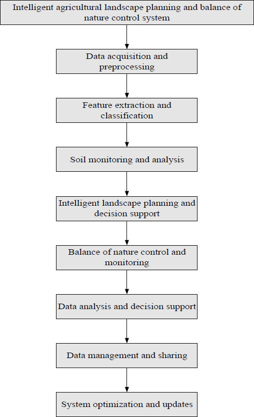
2. Intelligent agricultural landscape planning and ecological balance control system design
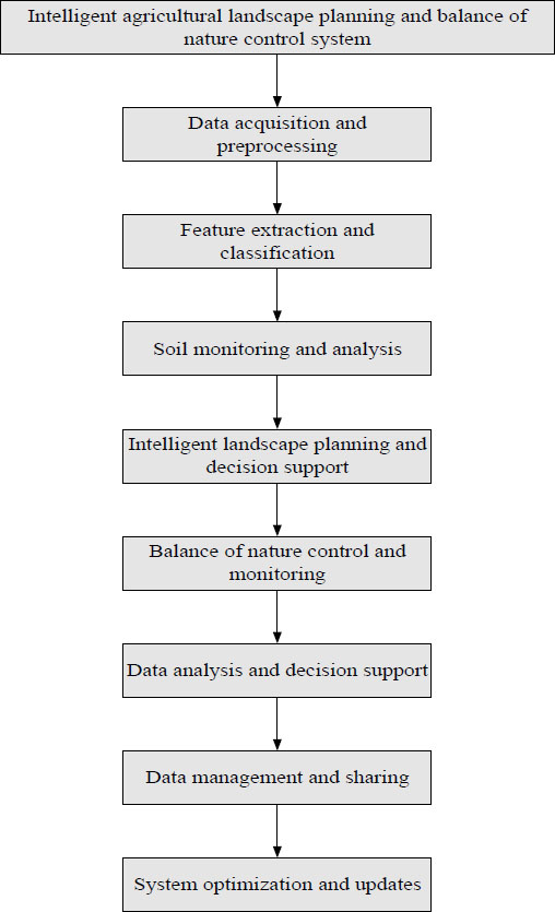
Intelligent agricultural landscape planning and ecological balance control systems are crucial for sustainable agricultural development (Barrios et al., 2018; Huntsinger et al., 2022). It realizes real-time monitoring and precise management of farmland ecology through remote sensing technology and intelligent algorithms, and helps farmers to achieve optimization of land use, rationalization of planting crops and reduction of pesticide use, thereby improving crop yield and quality. In addition, the system can also protect the ecological environment and promote biodiversity conservation, as well as prevent soil erosion and other environmental problems. The specific flow of the system construction is shown in Figure 1.

Design flowchart of intelligent agricultural landscape planning and ecological balance control system.
Citation: International Food and Agribusiness Management Review 28, 4 (2025) ; 10.22434/ifamr1048
2.1 Data collection and preprocessing
In order to achieve intelligent agricultural landscape planning and ecological balance control, it is first necessary to select suitable remote sensing data sources and establish corresponding data collection systems (Hung et al., 2022; Silveira dos Santos et al., 2022). Commonly used remote sensing data sources include high-resolution satellite images and drone images.
High resolution satellite imagery is a widely used remote sensing data source with advantages such as global coverage, wide-area observation capabilities, and long-term monitoring capabilities. The disadvantage of high-resolution satellite imagery is its high cost and the impact of weather conditions, cloud cover, and other factors. Modern high-resolution satellite images can provide pixel resolutions ranging from several meters to tens of centimeters, and spectral information of different bands can be obtained through satellite sensors. These data can be used to extract key information such as vegetation index, soil nutrient distribution, and crop type classification.
Drone images are a highly flexible remote sensing data source that can collect target areas at any time as needed, thus providing higher flexibility and resolution in farmland. Compared to high-resolution satellite images, drone images have higher flexibility, higher resolution, and more accurate data acquisition capabilities. By using high-resolution cameras or multispectral sensors installed on drone platforms, more detailed image information can be obtained, such as vegetation growth status, distribution of pests and diseases. Due to the lower flight altitude between the drone and the ground, it can provide higher accuracy image data.
In order to establish a data collection system, it is necessary to select suitable remote sensing platforms and sensors, and design reasonable task plans and data collection routes. In practical operations, multiple factors may need to be considered, such as the size of the region, the resolution requirements of the target, and the frequency of data collection. In addition, it is necessary to establish an effective image storage and management system to ensure the security and reliability of data.
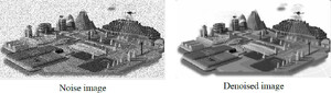
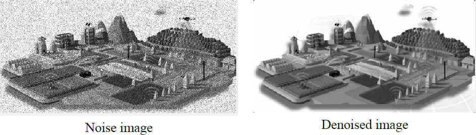
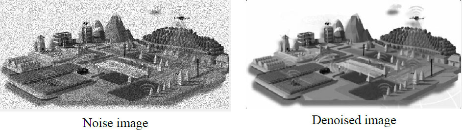
Remote sensing data images of agricultural landscape planning and ecological balance before and after denoising.
Citation: International Food and Agribusiness Management Review 28, 4 (2025) ; 10.22434/ifamr1048
In image preprocessing, common steps include denoising and radiation correction. Radiation correction refers to the process of correcting, calibrating, and normalizing the radiation values in an image, in order to eliminate the influence of lighting conditions and sensor characteristics on the image, and make the image more accurately reflect the true radiation status of the observed object. Denoising processing can reduce cluttered pixels and interference signals in the image, and improve the accuracy of subsequent image analysis (as shown in Figure 2). This is very important in subsequent image classification, feature extraction, and data analysis.
2.2 Feature extraction and classification
This study utilized computer vision technology and machine learning algorithms to extract and classify features from preprocessed remote sensing images. Feature extraction refers to extracting meaningful information from remote sensing images for subsequent classification, detection, and analysis. Common features include texture, color, and shape. In addition to texture, color, and shape, common features include grayscale, edges, corners, density, contrast, directionality, size, spectral reflectance, etc.
Texture features refer to the representation of surface details and structures in an image, which can help people identify different types of ground objects. Common texture feature extraction methods include grayscale co-occurrence matrix and wavelet transform. By calculating texture features, information about soil texture, vegetation disease degree, and other aspects can be obtained.
Color features refer to the color distribution and characteristics of objects in an image. Color features can provide important clues for different crop types and pest levels in remote sensing images. Common methods for extracting color features include color histograms and color moments. By extracting color features from images, different crop types, disease degrees, etc., can be distinguished.
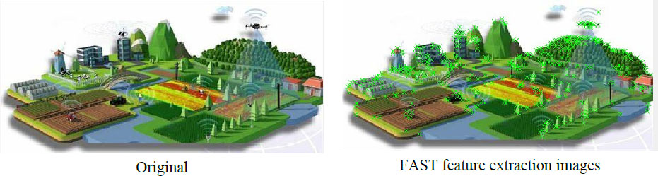
Shape features refer to the geometric and structural features of objects in an image. In remote sensing images, shape features can be used to detect and recognize different ground objects. Common shape features include area, perimeter, compactness, etc. Shape feature extraction can be used to analyze and classify land use types, crop growth status, etc. This article used the Scale Invariant Feature Transform (SIFT) feature extraction algorithm to extract features from remote sensing data images of agricultural landscape planning and ecological balance (as shown in Figure 3).
The SIFT algorithm has good performance in images with changes in translation, rotation, scaling, affine, lighting, and noise. The two-dimensional Gaussian kernel function can be expressed as:
Citation: International Food and Agribusiness Management Review 28, 4 (2025) ; 10.22434/ifamr1048
Among them, β is the standard deviation of the Gaussian kernel function, which represents the scaling factor in the SIFT algorithm, and its initial value is generally 1.6.
Feature extraction of remote sensing data images for agricultural landscape planning and ecological balance.
Citation: International Food and Agribusiness Management Review 28, 4 (2025) ; 10.22434/ifamr1048
Gauss Laplacian is an effective feature detection method for images, and the feature points detected by this method can fully reflect the features of the image. The Gaussian Laplace method has advantages such as sensitivity to details, good scale spatial resolution, and edge localization ability, which can effectively detect feature points in images.
Citation: International Food and Agribusiness Management Review 28, 4 (2025) ; 10.22434/ifamr1048
When the response value of the convolution operation between the image and the Laplace of Gaussian operator is the maximum, the corresponding position in the image is the position of the feature points. The two-dimensional image J(a, b) in a Gaussian scale space with scale can be obtained by convolution of image J(a, b) and Gaussian kernel function G a, b, β:
Citation: International Food and Agribusiness Management Review 28, 4 (2025) ; 10.22434/ifamr1048
The Gaussian scale space is divided into m groups, and the lowest level image in each group can be obtained by sampling a certain level image from the previous group:
Citation: International Food and Agribusiness Management Review 28, 4 (2025) ; 10.22434/ifamr1048
Here, N and M represent the length and width of the initial image, and d represents the logarithmic value of the minimum dimension of the top-level image.
In addition to feature extraction, it is also necessary to input the extracted features into machine learning algorithms for classification. Machine learning algorithms can use the extracted features to train models and achieve automatic classification of remote sensing images. Common machine learning algorithms include support vector machines, random forests, and deep learning algorithms such as convolutional neural networks. These algorithms can classify images based on input features to identify different crop types, soil textures, and pest levels. It is worth noting that in order to improve the accuracy of classification, it is also necessary to fully annotate the sample data and conduct model training and validation. In addition, data augmentation techniques can be used to expand the sample dataset and increase the generalization ability of the classification model.
2.3 Soil monitoring
Soil monitoring and analysis play an important role in the field of intelligent agriculture (Di and Robertson, 2021; Lane et al., 2020). By collecting soil samples and conducting laboratory tests, this article can obtain a series of parameters related to soil quality, such as soil nutrient content, pH (potential of hydrology) value, and water content. The accurate acquisition of these parameters is of great significance for understanding soil characteristics, optimizing fertilization plans, and rational water use.
At the same time, remote sensing technology can also provide valuable auxiliary information for soil monitoring and analysis. Remote sensing image data can provide high-resolution images of large-scale land cover, helping observers quickly obtain land use information and capture potential soil characteristics. Therefore, combining soil sample analysis and remote sensing image data can establish spatial distribution models for parameters such as soil nutrients, pH value, and water content, providing reference for agricultural landscape planning.
In the stage of soil sample collection and laboratory testing, this article needs to determine the sampling points based on land type and usage purpose, and collect soil samples. In the laboratory, soil samples would be tested for nutrient content, pH value, and moisture content. These test results would provide basic data for subsequent analysis and model building.
Remote sensing image data can be used to obtain large-scale land surface information. By processing remote sensing images, this article can extract features such as land type, vegetation coverage, and land texture. These features have a certain correlation with soil quality and can provide supplementary information for subsequent soil analysis and model establishment.
Combining soil sample testing results with remote sensing image data can establish a correlation model between soil characteristics and remote sensing parameters. Through data mining and machine learning algorithms, it is possible to predict and speculate on the spatial distribution of parameters such as soil nutrients, pH value, and water content. These models can provide decision support and help agricultural practitioners better manage soil and adjust fertilization.
The established soil feature spatial distribution model can provide reference for agricultural landscape planning. According to the soil characteristics and needs of different land regions, differentiated crop selection, fertilization schemes, and irrigation management can be carried out. This would help improve crop yield and quality, and minimize resource waste and environmental pollution to the greatest extent possible.
2.4 Intelligent landscape planning and decision support
By integrating remote sensing image classification results, soil analysis data, and agricultural expert knowledge, an intelligent decision-making model is designed to achieve intelligent landscape planning in areas such as farmland segmentation, crop matching, and planting density (Girma et al., 2018; Haan et al., 2020). At the same time, based on data platforms, agricultural decision support tools can also be provided, providing suggestions for farmers and agricultural experts to optimize planting plans and resource allocation.
By using remote sensing image classification results, spatial distribution information and vegetation coverage data of farmland can be obtained. By analyzing and processing these data, farmland can be divided into different blocks for different agricultural management and planting operations. For arid areas, areas with abundant water resources can be classified as irrigation areas, while other areas can be classified as drought adaptive crop planting areas.
By combining soil analysis data, key parameters such as nutrient content, pH value, and water content of the soil can be understood. These parameters have a significant impact on crop growth and yield. By combining soil analysis data with crop demand and the characteristics of excellent varieties, a reasonable planting plan can be developed. For soil areas with low nutrient content, this article can select crop varieties that are suitable for poor soil and implement targeted fertilization measures.
By utilizing the experience and knowledge of agricultural experts, agricultural decision-making models and algorithms can be established and integrated into intelligent landscape planning. These models and algorithms can predict crop growth and yield based on historical data and real-time monitoring data, and provide farmers with suggestions for farmland management and decision-making. Based on weather forecasts and water resource conditions, irrigation plans can be adjusted and farmers can be reminded to take corresponding measures.
Building agricultural decision support tools based on data platforms can provide suggestions for farmers and agricultural experts to optimize planting plans and resource allocation (Morales-Hojas et al., 2020). By integrating and analyzing a large amount of agricultural data, such as meteorological data, soil data, and market demand data, personalized agricultural decision-making recommendations are generated. These tools can help farmers better manage their farmland, adjust planting plans and maximize agricultural production efficiency and sustainability.
2.5 Ecological balance control and monitoring
The use of sensor networks and real-time monitoring systems for monitoring and recording agricultural environmental parameters is the key to achieving ecological balance control (Bhadoria and Chaudhari, 2019; Tscharntke et al., 2021). By collecting meteorological data (such as temperature, humidity, precipitation, etc.), soil moisture content, and pesticide use information, comprehensive monitoring of the agricultural ecological environment can be achieved. In terms of ecological balance control, the following strategies can be adopted:
Regular irrigation: based on real-time monitoring of soil moisture content and crop water demand, irrigation plans can be reasonably arranged. By using automated irrigation systems, the risk of water waste and soil erosion caused by excessive or insufficient irrigation can be reduced (Shan and Lai, 2019).
Precision fertilization: by combining soil nutrient content and crop demand, precise fertilization technology is adopted to adjust the fertilization plan (Choo, 2020). This can reduce the use of pesticides and fertilizers, and avoid soil pollution and water eutrophication caused by excessive fertilization, thereby improving fertilizer utilization efficiency (Wu et al., 2023).
Early warning and prevention and control measures for pests and diseases: by monitoring the occurrence and spread of pests and diseases, timely warning and corresponding prevention and control measures are taken. By utilizing sensor networks and image recognition technology, real-time monitoring and identification of agricultural pests and diseases can be achieved, and effective prevention and control measures can be taken by farmers in a timely manner, thereby reducing the use of chemical pesticides and protecting the ecological environment and human health (Edrisen, 2020; Shan, 2018).
Ecological compensation measures: by establishing an ecological compensation mechanism, farmers are encouraged to adopt ecological agricultural measures such as planting green manure and rotating fallow to promote soil conservation and biodiversity restoration, and maintain ecological balance in farmland (Fourniotis, 2020).
2.6 Data analysis and decision support
Based on real-time monitoring data and historical statistical data, and utilizing big data analysis and artificial intelligence technology, this article established a more accurate model and prediction model for agricultural ecological environment, providing more comprehensive decision support and optimization plans for farmers and agricultural experts (Li et al., 2021; Wu et al., 2022).
System analysis layer
The complexity of patch shape in landscape remote sensing images is characterized by fractal dimension, and the calculation method is:
Citation: International Food and Agribusiness Management Review 28, 4 (2025) ; 10.22434/ifamr1048
where E is the fractal dimension, and J and I represent the perimeter and area of the patch.
The system controls ecological landscape balance through diversity index, and the calculation method of diversity index is:
Citation: International Food and Agribusiness Management Review 28, 4 (2025) ; 10.22434/ifamr1048
where Qj represents the proportion of the area of the j-th type of landscape; n is the number of landscape types.
In landscape planning, the degree of uniformity of each part of the landscape type is represented by the evenness index. The value is directly proportional to the uniformity of landscape distribution. The diversity index can be used to calculate the evenness of landscape balance.
Citation: International Food and Agribusiness Management Review 28, 4 (2025) ; 10.22434/ifamr1048
where S is the uniformity index, and F and Fmax represent the diversity index and the upper limit of the diversity index, respectively.
Meteorological data analysis: by analyzing real-time collected meteorological data such as temperature, humidity, precipitation, wind speed, etc., combined with crop demand models, reasonable irrigation suggestions can be provided. During drought periods, it is recommended to increase irrigation appropriately based on soil moisture content and crop water demand to maintain normal crop growth.
Soil nutrient analysis: by collecting and testing soil samples, data on soil nutrient content can be obtained. By combining historical data and crop nutrient demand models, the nutrient status of the soil can be analyzed and precise fertilization recommendations can be provided. If a certain nutrient in the soil is excessive, the corresponding fertilizer input can be reduced to avoid environmental pollution and resource waste caused by excessive fertilization.
Early warning and prevention plan for pests and diseases: by utilizing technologies such as sensor networks and image recognition, real-time monitoring of pests and diseases in farmland can be achieved. By analyzing the collected data, a disease and pest warning model can be established to detect and predict the outbreak trend of diseases and pests as soon as possible. At the same time, combining historical data and expert knowledge to provide targeted prevention and control plans and optimization strategies can reduce the use of chemical pesticides and reduce their adverse effects on the environment.
Crop growth prediction and optimization: this article established a crop growth prediction model based on historical data, real-time monitoring data, and meteorological forecast data. By analyzing the comprehensive effects of factors such as soil nutrients, climate conditions, and pests and diseases, the growth and yield levels of crops can be predicted. Based on the predicted results, optimizing cultivation management measures, adjusting irrigation, fertilization, and pest control plans can maximize the output and economic benefits of farmland.
Data visualization and decision support: this article visualized the analysis results and presents them in an intuitive form to farmers and agricultural experts (Daradkeh, 2019). In this way, they can more easily understand and utilize data to make scientific decisions. At the same time, using artificial intelligence technology, personalized decision support and optimization plans can be generated based on user needs and specific situations.
Through big data analysis and artificial intelligence technology, a farmland ecological environment model and prediction model have been established, which can provide accurate and real-time decision support and optimization plans for farmers and agricultural experts, and help them regulate the farmland ecological environment reasonably, thereby improving agricultural production level and achieving a win-win situation between farmland ecology and economic benefits.
In order to verify the application value of the landscape ecological balance control system based on remote sensing images designed in this article, experimental research was conducted (Daradkeh, 2019).
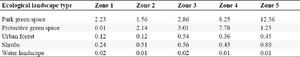
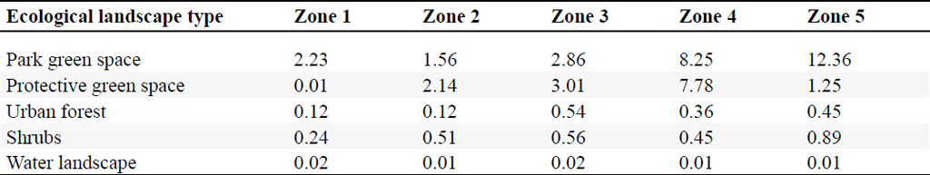
The urban area of a certain city was selected as the research object and divided into five specific zones. The composition of the ecological landscape in the study area is shown in Table 1.
Ecological landscape of the study area (km2).
Citation: International Food and Agribusiness Management Review 28, 4 (2025) ; 10.22434/ifamr1048
Remote sensing image segmentation performance
Citation: International Food and Agribusiness Management Review 28, 4 (2025) ; 10.22434/ifamr1048
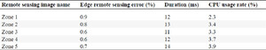
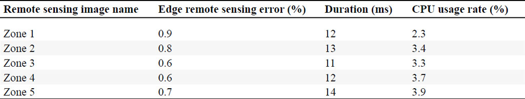
The remote sensing images of the research area were extracted using the system described in this article, and the necessary information for landscape ecological balance control was obtained (Hou, 2022). The performance of the system for segmenting remote sensing image edges in this article is shown in Table 2.
From the data in Table 2, it can be seen that in the process of segmenting remote sensing image edges in this paper, the CPU utilization rate was all below 4%, and the average segmentation time for each region was only about 12 ms, with an edge segmentation error of no more than 1%. This also indicated that the ecological landscape segmentation system in this paper had high efficiency, strong stability, and low resource consumption in remote sensing images, demonstrating superior image segmentation performance (Kavita, 2021; Yang et al., 2022).
2.7 Data management and sharing
In order to effectively manage and share data related to farmland ecological environment, a unified data management platform can be established. This platform can include the following aspects:
Image data storage and management: agricultural ecological environment monitoring usually requires the use of image data, such as remote sensing images, pest and disease images, etc. In the data management platform, a dedicated image data storage and management system can be established. This system can provide efficient storage and indexing functions for fast retrieval and processing of large amounts of image data. At the same time, in order to improve the security and reliability of data, data backup and redundant storage measures can be adopted to ensure that data is not lost or damaged (Kim, 2022).
Soil analysis results database: soil analysis is an important component of farmland ecological environment management. A database of soil analysis results can be established to record and manage the soil sample analysis results of various farmland. This database can contain information such as soil nutrient content, pH, and heavy metal content. Through this database, farmers and agricultural experts can query and compare soil analysis results of different farmland, thereby formulating more scientific fertilization and crop planting plans.
Agricultural decision support system: the data management platform can also be combined with agricultural decision support systems. This system can utilize stored data such as meteorological data, soil analysis results, and pest monitoring data for comprehensive analysis and modeling, thereby providing accurate decision-making support for farmers and agricultural experts. This system can generate personalized decision suggestions based on the needs of different users, including irrigation suggestions, fertilization plans, pest control strategies, etc.
In data management platforms, data security and privacy protection are very important considerations. On the one hand, strict data security measures need to be taken, such as encrypted transmission, permission management, access control, etc., to prevent data from being obtained or tampered with by unauthorized personnel. On the other hand, it is necessary to comply with relevant laws and regulations and privacy protection policies to ensure that users’ personal information and sensitive data are properly protected.
In order to promote cooperation and communication among all parties, a data sharing mechanism is also essential. The data management platform can provide data sharing functionality, allowing farmers, agricultural experts, government departments, and research institutions to share data resources. By sharing data, different stakeholders can better understand and respond to changes and challenges in the agricultural ecological environment, and jointly promote sustainable agricultural development.
2.8 System optimization and updates
Introducing advanced technologies and algorithms: with the continuous development of technology, new technologies and algorithms can help improve the intelligence level of the system.
Real time data update: in order to maintain the accuracy and practicality of the system, remote sensing image data, soil analysis results, and agricultural expert knowledge base can be updated in a timely manner. By regularly obtaining the latest remote sensing image data and conducting image processing and analysis, the latest farmland information can be obtained. At the same time, timely collection and organization of the experience and knowledge of agricultural experts can form a reliable knowledge base, providing real-time decision-making support for farmers and agricultural experts.
Integrating multi-source data: in order to have a more comprehensive understanding of the agricultural ecological environment, multi-source data can be integrated, such as meteorological data, agricultural water quality data, disease and pest monitoring data, etc. By integrating these data, the correlation and impact between different factors can be analyzed, providing more comprehensive decision support.
User feedback and improvement: it is necessary to maintain close communication with farmers and agricultural experts, and timely collect user feedback and needs. Based on user feedback, the system has been improved and optimized to improve user experience and satisfaction.
Promotion and training: in order to benefit more farmers and agricultural experts from intelligent agricultural landscape planning and ecological balance control systems, promotion and training work can be strengthened. By conducting training courses, organizing technical exchange meetings, and writing user manuals, users can better understand and use the system.
Data security and privacy protection: in the process of optimizing and updating the system, special attention should be paid to data security and privacy protection. Appropriate measures such as data encryption, access control, and security auditing should be taken to protect the security and privacy of user data.
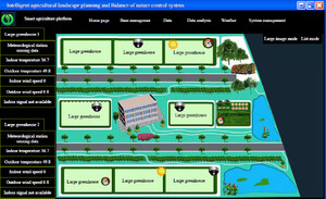
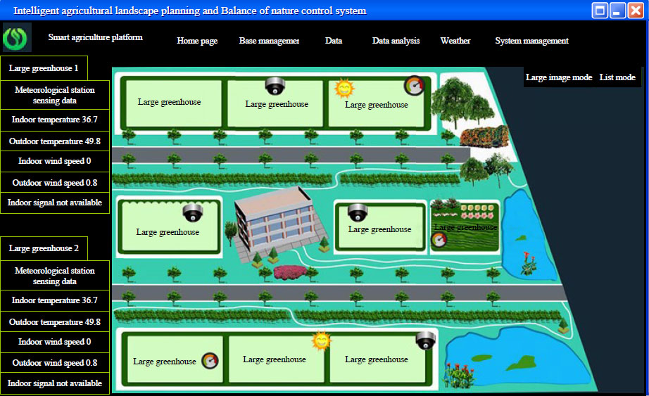
Intelligent agricultural landscape planning and ecological balance control system diagram.
Citation: International Food and Agribusiness Management Review 28, 4 (2025) ; 10.22434/ifamr1048
By continuously optimizing and updating the intelligent agricultural landscape planning and ecological balance control system, introducing advanced technologies and algorithms, timely updating data, integrating multi-source data, maintaining close feedback and improvement with users, and strengthening promotion and training work, the intelligence level of the system can be improved, and more accurate and practical decision support can be provided, thereby promoting the sustainable development of agriculture. At the same time, attention should be paid to data security and privacy protection to ensure the normal operation of the system and the security of user data. The intelligent agricultural landscape planning and ecological balance control system is shown in Figure 4.
3. Performance evaluation and optimization of intelligent agricultural landscape planning and ecological balance control system
3.1 Experimental design
Experimental purpose: this experiment aimed to compare the differences in accuracy, practicality, and efficiency between traditional agricultural ecological environment monitoring methods and intelligent agricultural landscape planning and ecological balance control systems based on remote sensing images, as well as evaluate the advantages and potential of intelligent systems in agricultural ecological environment monitoring compared to traditional methods.
Group setting: the traditional agricultural ecological environment monitoring method was set as the control group, and the intelligent agricultural landscape planning and ecological balance control method based on remote sensing images was set as the experimental group.
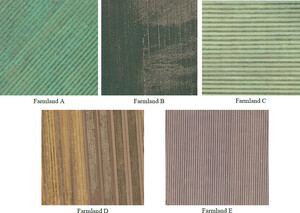
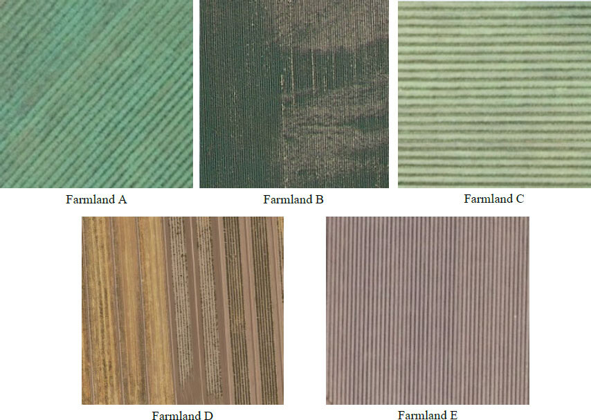
Remote sensing images of farmlands.
Citation: International Food and Agribusiness Management Review 28, 4 (2025) ; 10.22434/ifamr1048
Experimental subjects: this article selected 5 farmlands for the experiment, labeled A, B, C, D and E. The experiment used two methods to detect it and recorded the data. Among them, remote sensing technology was used to extract materials from the 5 farmlands. The remote sensing images are shown in Figure 5.
Experimental steps
Step 1: Data acquisition and processing
Relevant data such as vegetation coverage, soil moisture, and temperature were obtained using traditional agricultural ecological environment monitoring methods. At the same time, the same data was also obtained from the intelligent agricultural landscape planning and ecological balance control system based on remote sensing images.
The collected data was preprocessed, including denoising, image segmentation, and feature extraction methods, to ensure the accuracy and comparability of the data.
Step 2: Accuracy comparison
For the three indicators of vegetation coverage, soil moisture, and temperature, traditional methods and intelligent systems are used for measurement and calculation, respectively. The results obtained by traditional methods and intelligent systems were compared and an accurate comparison was obtained.
Step 3: Practicality comparison
The differences between traditional methods and intelligent systems in terms of data acquisition difficulty, data processing time and reliability of results were compared. Based on the actual situation, the feasibility and practicality of the traditional methods and intelligent systems in practical applications were evaluated.
Step 4: Efficiency comparison
Differences between traditional methods and intelligent systems in terms of resource utilization efficiency, productivity and working time were compared. Based on the experimental data, the effectiveness of the traditional methods and the intelligent system in improving the productivity and reducing the working time in the farmland was evaluated.
Step 5: Comprehensive comparison
The comparison results of accuracy, practicality, and efficiency were weighted and synthesized to obtain a comparison between traditional methods and intelligent system comprehensive evaluation. Based on the comprehensive comparison results, the advantages and potential of intelligent systems in monitoring agricultural ecological environment compared to traditional methods were evaluated.
3.2 Experimental data
Accuracy comparison
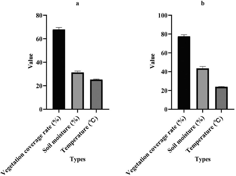
This article compared the intelligent agricultural landscape planning and ecological balance control system based on remote sensing images with traditional agricultural ecological environment monitoring methods, and compared the advantages and improvement space of the system in terms of accuracy. Traditional method and intelligent system were used to measure and calculate the three indicators of vegetation coverage, soil moisture, and temperature, respectively. The test results are shown in Figure 6.
Accuracy comparison between two systems. (a) Control group, (b) experimental group.
Citation: International Food and Agribusiness Management Review 28, 4 (2025) ; 10.22434/ifamr1048
Figure 6a shows the accuracy test results of the control group, while Figure 6b shows the accuracy test results of the experimental group. By comparing the measurement results of vegetation coverage, soil moisture, and temperature between traditional methods and intelligent agricultural landscape planning and ecological balance control systems based on remote sensing images, the following results can be obtained:
The intelligent system performed more accurately in measuring vegetation coverage compared to traditional method. The vegetation coverage measured by intelligent systems was relatively high and the relative error was small, while the measurement results of traditional methods were relatively low. Among them, under traditional method, the vegetation coverage of farmland A was 70%, while under the intelligent agricultural landscape planning scheme based on remote sensing images, the vegetation coverage of farmland A was 75%. This may be because intelligent systems can monitor and calculate vegetation more accurately through remote sensing images.
The intelligent system also performed more accurately in measuring soil moisture compared to traditional method. The soil moisture measured by intelligent systems was relatively high and the relative error was small, while the measurement results of traditional methods were relatively low. Among them, under traditional methods, the soil moisture of farmland A was 30%, while under the intelligent agricultural landscape planning scheme based on remote sensing images, the soil moisture of farmland A was 40%. This may be because intelligent systems can use remote sensing images to obtain more comprehensive soil moisture information and accurately calculate it in conjunction with other data.
In terms of temperature measurement, the results of traditional method and intelligent system were relatively close, and the difference was not significant. Therefore, in terms of temperature, traditional methods may already have high accuracy, while intelligent systems have relatively small advantages in improving accuracy.
The intelligent agricultural landscape planning and ecological balance control system based on remote sensing images had significant accuracy advantages over traditional methods in measuring vegetation coverage and soil moisture. However, there was little difference in accuracy between the two methods in temperature measurement. For intelligent systems, there was still room for further improvement in accuracy, which could be improved by optimizing algorithms, increasing data sources, and other methods.
Practical comparison
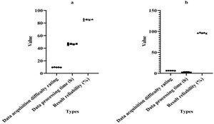
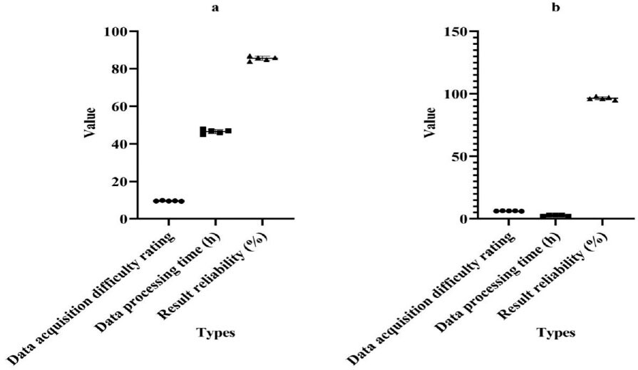
In order to compare the differences between traditional methods and intelligent systems in terms of data acquisition difficulty, data processing time, and result reliability, this article applied the traditional method and intelligent system to five farmland plots, and calculated their data acquisition difficulty, data processing time, and result reliability. The test results are shown in Figure 7.
Comparison of practicality between two systems. (a) Control group, (b) experimental group.
Citation: International Food and Agribusiness Management Review 28, 4 (2025) ; 10.22434/ifamr1048
Figure 7a shows the practicality test results of the control group, and Figure 7b shows the practicality test results of the experimental group. By comparing the test results of traditional method and intelligent system in terms of data acquisition difficulty, data processing time, and result reliability, it can be concluded that intelligent system performed better in terms of data acquisition difficulty compared to traditional method. From Figure 7, it can be seen that the difficulty rating of data acquisition in intelligent system was lower, compared to the higher rating of traditional method.
Among them, the difficulty score of data acquisition for farmland A under traditional method was 9.6 points, while the difficulty score of data acquisition for farmland A under the intelligent agricultural landscape planning scheme based on remote sensing images was 6.3 points. This may be because intelligent systems can automatically obtain relevant data of farmland through remote sensing images, reducing the workload and difficulty of manual collection. Intelligent systems perform faster in data processing time compared to traditional methods. The data processing time of intelligent system was relatively short, only a few hours, while traditional method required a longer time for data processing. This may be because intelligent system had powerful computing power and could quickly process a large amount of data, while traditional method required human intervention and consume a lot of time.
The intelligent agricultural landscape planning and ecological balance control system based on remote sensing images had obvious practical advantages compared to traditional methods. Intelligent systems had lower difficulty in data acquisition, shorter data processing time, and highly reliable results. This made intelligent systems more suitable for large-scale farmland monitoring and management, which can improve efficiency, save human resources, and provide reliable basis for farmland decision-making.
Efficiency comparison
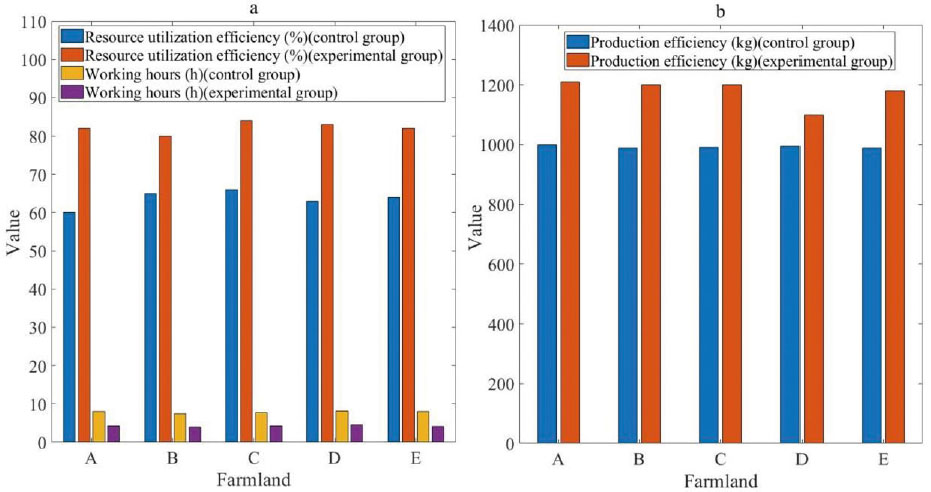
In order to compare the differences between traditional methods and intelligent systems in resource utilization efficiency, production efficiency, and working time, this article evaluated the effectiveness of traditional method and intelligent system in improving agricultural production efficiency and reducing working time based on experimental data. The experimental test results are shown in Figure 8.
Comparison of efficiency between two systems. (a) Resource utilization efficiency and working time, (b) production efficiency.
Citation: International Food and Agribusiness Management Review 28, 4 (2025) ; 10.22434/ifamr1048
Figure 8a shows the test results of resource utilization efficiency and working time under two systems, and Figure 8b shows the production efficiency test results under two systems. By comparing the test results of traditional methods and intelligent systems in terms of resource utilization efficiency, production efficiency, and working time, it can be concluded that intelligent system performed better in resource utilization efficiency compared to traditional method. Using the traditional method, the resource utilization efficiency of farmland A was 60%, while under the intelligent agricultural landscape planning scheme based on remote sensing images, the resource utilization efficiency of farmland A was 82%. This may be because intelligent systems can effectively utilize farmland resources and improve resource utilization efficiency through intelligent decision-making and optimization algorithms. Compared to traditional method, intelligent system performed shorter working hours. This may be because intelligent systems have the characteristics of automation and high efficiency, which can quickly complete various tasks and save human resources. Compared to traditional method, intelligent system performed higher in production efficiency. This may be because intelligent systems can provide more scientific and accurate farmland management measures through precise analysis of farmland data and decision support, thereby improving the production efficiency of farmland.
The intelligent agricultural landscape planning and ecological balance control system based on remote sensing images had obvious efficiency advantages compared to traditional methods. Intelligent system had higher resource utilization efficiency, shorter working hours, and higher production efficiency. This enabled intelligent systems to increase the yield and efficiency of farmland, and reduce labor input and time costs. However, the application of intelligent systems still needs to be evaluated and adjusted based on actual farmland conditions, ensuring their applicability in different farmland environments, and paying attention to the rational use of agricultural resources and protecting the ecological environment.
Comprehensive testing
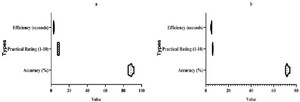
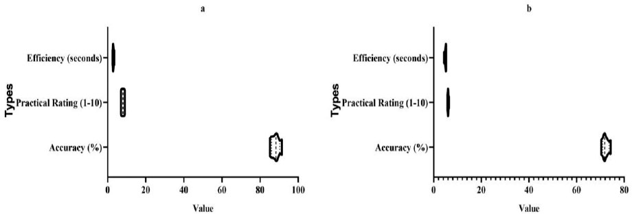
In order to weight and synthesize the comparison results of accuracy, practicality, and efficiency, and obtain the comparison results of traditional methods and intelligent system comprehensive evaluation, this article evaluated the advantages and potential of intelligent system in agricultural ecological environment monitoring compared to traditional method based on the comprehensive comparison results. The specific experimental test data is shown in Figure 9.
Comprehensive comparison between two systems. (a) Experimental group, (b) control group.
Citation: International Food and Agribusiness Management Review 28, 4 (2025) ; 10.22434/ifamr1048
Figure 9a shows the comprehensive test results of the experimental group, and Figure 9b shows the comprehensive test results of the control group. According to the data in Figure 9, it can be concluded that in terms of accuracy, the results of intelligent system were superior to traditional method. The average accuracy of intelligent system was 88.16%, while the average accuracy of traditional method was only 72.2%. This indicated that intelligent system could more accurately monitor the ecological environment of farmland. In terms of practicality, intelligent system also showed significant advantages. The practical rating of intelligent system ranged from 7 to 9, while traditional method had ratings ranging from 5.8 to 6.5. This indicated that intelligent system was more practical in practical applications, and users had higher evaluations of them. In terms of efficiency, intelligent system was also slightly ahead. The average monitoring time of intelligent system was 2.94 seconds, while the average time of traditional method was 4.86 seconds. Although the difference was not significant, intelligent system was slightly faster in monitoring speed.
Compared to traditional methods, intelligent systems have obvious advantages and potential in monitoring agricultural ecological environment. It can provide more accurate results, more practical functionality, and slightly more efficient. Therefore, intelligent systems have broad application prospects in the field of agricultural ecological environment monitoring.
This study discusses business model innovation, which has a significant impact on value creation. First, smart agricultural systems not only provide basic farmland monitoring data, but also provide value-added services through data analysis and intelligent decision-making. These value-added services include personalized planting advice, optimization of farmland management plans, etc., which can help farmers increase yields and efficiency, thereby creating more value. Second, the application of smart agricultural systems requires multi-party cooperation, involving sensor manufacturers, data processing companies, agricultural experts, farmers and other stakeholders. This cooperation model promotes the coordinated development of the entire industrial chain, with all parties working together to improve agricultural production efficiency and achieve common value creation. Third, the introduction of smart agricultural technology has given rise to a series of new business models based on smart technology, such as farmland data services and smart agriculture solution providers. These new business models have brought new business opportunities to enterprises in the upstream and downstream of the agricultural industry chain, and promoted the development and upgrading of the entire industry.
4. Conclusions
According to the experimental results of comparing traditional agricultural ecological environment monitoring methods with intelligent agricultural landscape planning and ecological balance control systems based on remote sensing images, it can be concluded that intelligent systems can achieve more accurate monitoring and calculation through remote sensing image data. Intelligent systems have the characteristics of automation and high efficiency, which can quickly obtain and process large amounts of data, and provide reliable results. Intelligent systems can effectively utilize farmland resources and improve resource utilization and production efficiency, while saving human resources and working time. Intelligent systems have high accuracy, practicality, and efficiency, which can improve agricultural production efficiency and save resources and time costs. During the experimental process, there were also some shortcomings. Small sample size: this article only selected 5 farmlands for the experiment, with a small sample size and limited representativeness of the experimental results. When conducting further research, it may be considered to increase the sample size, including more farmland areas, different types of crops, and data collection from different seasons, in order to improve the reliability and generalization ability of the experimental results. In the experimental verification, this article only conducted demonstration applications for specific regions, and further expansion of the experimental scope is needed to verify the applicability of the system in different regions and crops.
References
Barrios E., V. Valencia, M. Jonsson, A. Brauman, K. Hairiah, P.E. Mortimer and S. Okubo. 2018. Contribution of trees to the conservation of biodiversity and ecosystem services in agricultural landscapes. International Journal of Biodiversity Science, Ecosystem Services & Management 14 (1): 1–16.
Bhadoria, R.S. and N.S. Chaudhari. 2019. Pragmatic sensory data semantics with service-oriented computing. Journal of Organizational and End User Computing 31 (2): 22–36.
Chen, J., Z. We, J. Liu and X. Zheng. 2021. Technology sharing and competitiveness in a Stackelberg model. Journal of Competitiveness 13 (3): 5–20.
Choo, K.R. 2020. Pesticide pollution affects the functional diversity of soil microbial community. Academic Journal of Environmental Biology 1 (2): 44–53.
Daradkeh, M. 2019. Determinants of self-service analytics adoption intention: the effect of task-technology fit, compatibility, and user empowerment. Journal of Organizational and End User Computing 31 (4): 19–45.
Di, L. and G.P. Robertson. 2021. Nitrification is a minor source of nitrous oxide (N2O) in an agricultural landscape and declines with increasing management intensity. Global Change Biology 27 (21): 5599–5613.
Edrisen, Z. 2020. Marine engineering environmental protection based on the concept of ecological environment. Frontiers in Ocean Engineering 1 (4): 44–52.
Girma, S., J. Schultner, I. Dorresteijn, J. Hanspach, K. Hylander and F. Senbeta. 2018. Land use legacy effects on woody vegetation in agricultural landscapes of south‐western Ethiopia. Diversity and Distributions 24 (8) (2018): 1136–1148.
Haan, N.L., Z. Yajun and A.L. Douglas. 2020. Predicting landscape configuration effects on agricultural pest suppression. Trends in Ecology & Evolution 35 (2) (2020): 175–186.
Hong, Y., X. Lu and H. Zhao. 2021. The diversity characteristics and interannual dynamics of birds in different habitats of agricultural landscape in the huanghuai plain. Acta Ecologica Sinica 41 (5): 2045–2055.
Hou, H. 2022. The construction and analysis of natural environmental protection system based on the concept of ecological balance. Nature Environmental Protection 3 (4): 60–68.
Hung, S.-H, C.C. Wu, Y.C. Yeh, A. Yeh, C.Y. Chang and H.F. Tang. 2022. “A study on measuring ecosystem service and physical and psychological health benefits in agricultural landscape.” HortScience 57 (6): 708–714.
Huntsinger, L., M. Penker, T. Dimopoulos, T. Kizos, O. Saito and K.S. Zimmerer. 2022. Landscape products for sustainable agricultural landscapes. Nature Food 3 (10): 814–821.
Jiang, J., Q. Yang, Q. He and K. Shi. 2023. Changes and driving forces of agricultural landscape vulnerability in southwestern mountainous areas: A case study of Shizhu County, Chongqing. Economic Geography 43 (1): 177–187.
Kavita, U. 2021. Visual intelligent recognition system based on visual thinking. Kinetic Mechanical Engineering 2 (1) 46–54.
Kim, J. 2022. Blockchain supply information sharing management system based on embedded system. Distributed Processing System, Vol. 3, Issue 2: 60–77.
Lane, I.G., C.R. Herron-Sweet, Z.M. Portman and D.P. Cariveau. 2020. Floral resource diversity drives bee community diversity in prairie restorations along an agricultural landscape gradient.” Journal of Applied Ecology 57 (10) (2020): 2010–2018.
Li, X., H. Liu and W. Wang, Y. Zheng, H. Lv and Z. Lv. 2021. Big data analysis of the Internet of Things in the digital twins of smart city based on deep learning. Future Generation Computer Systems 128: 167–177.
Morales‐Hojas, R., J. Sun, F.A. Irazoiz, X. Tan and J. Chen. 2020. Contrasting population structure and demographic history of cereal aphids in different environmental and agricultural landscapes. Ecology and Evolution 10 (18): 9647–9662.
Fourniotis, N.Th. 2020. Evaluation natural environment protection system based on IPA algorithm. Nature Environmental Protection 1 (1): 18–26.
Qi, H. and C. Fucun. 2019. Analysis of the landscape planning of Northeast Agricultural Sightseeing Park. Western Leather 41 (1): 103.
Shan, P.F. 2018. Image segmentation method based on K-mean algorithm. EURASIP Journal on Image and Video Processing (2018): 81.
Shan, P. and X. Lai. 2019. Influence of CT scanning parameters on rock and soil images. Journal of Visual Communication and Image Representation 58 (1): 642–650.
Silveira dos Santos, J., C.M. Silva-Neto, T. Silva, K.N. Siqueira, M.C. Ribeiro, and R.G. Collevatti. 2022. Landscape structure and local variables affect plant community diversity and structure in a Brazilian agricultural landscape. Biotropica 54 (1): 239–250.
Tscharntke, T., I. Grass, T.C. Wanger, C. Westphal and P. Batáry. 2021. Beyond organic farming–harnessing biodiversity-friendly landscapes. Trends in Ecology & Evolution 36 (10): 919–930.
Wang, X., Q. Meng, S. Zhao, J. Li, L. Zhang and C. Xu. 2020. The application of gf-2 in urban green space classification and landscape pattern measurement. Journal of Geo-Information Science 22 (10): 1971–1982.
Wu, J., R. Tao, P. Zhao, N.F. Martin and N. Hovakimyan. 2022. Optimizing nitrogen management with deep reinforcement learning and crop simulations. In Proceedings of the IEEE/CVF Conference on Computer Vision and Pattern Recognition, pp. 1712–1720.
Wu, J., D. Pichler, D. Marley, D. Wilson, N. Hovakimyan and J. Hobbs. 2023. Extended agriculture-vision: an extension of a large aerial image dataset for agricultural pattern analysis. arXiv preprint: 2303.02460.
Yang, B., M. Liu, Y. Wang, K. Zhang and E. Meijering. 2022. Structure-guided segmentation for 3d neuron reconstruction. IEEE Transactions on Medical Imaging 41 (4): 903–914.
Corresponding author


