1 Introduction
Navigation is the most essential and delicate operation in shipping. It is the reason the ship is paid for the safe, fast, and efficient transport of cargo and people. However, this fundamental part of the shipping business is overlooked by historians, who tend to focus on other aspects, like types of trades, merchant networks, business organization, ships and shipbuilding, ports, shipping finance, marine insurance, and many others. Most of the existing works on navigation are related to the development of the art of navigation, the explorations of the seas, and discoveries,1 but only a few deal with specific aspects of navigation in relation to the operation and the performance of the ship in maritime trade.2 This paper aims to do this; to analyse aspects of the navigation of cargo sailing ships and steamers from the 1860s to the 1920s, and to examine changes in navigation and the impact they had on Mediterranean seafarers and shipping during this period of transition from sail to steam. The analysis will be based on information from logbooks, and secondarily from the account books of Greek sailing ships and steamers, and may offer an exemplary case of the evolution of navigation of one of the most rapidly emerging Mediterranean merchant marines in the nineteenth and early twentieth centuries. The main documentation from logbooks concerns five sailing ships (four brigs, one barquentine) and five cargo steamers. The sailing ship data stretches from 1866 to 1889 covering the last period of the apogee of sail in the Mediterranean. Steamship data covers the period from 1888 to 1927, from the earliest Greek cargo steamers to their great diffusion in the first decade of the twentieth century, up to the reconstitution of the Greek steamship fleet after the massive losses of the First World War in the 1920s (Table 13.1).3
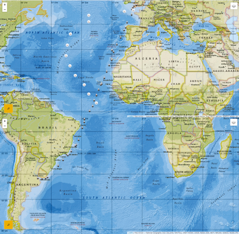
The data from the logbooks is processed within a novel application called Ship Voyages, (http://www.sealitproject.eu/digital-seafaring), a map visualization, which enables us to follow the routes of ships, visit the related transcribed data, and check the information or find other information that does not appear within the map visualization, such as events that took place during a particular ship voyage.4 The analysis of the main questions on navigation is based on this new instrument of map visualization, which enables us to examine, compare, and assess, accurately and clearly, various aspects of navigation. Therefore, the data visualization from Ship Voyages is structurally integrated into the following axes of analysis: a) the development of trade routes and of areas of navigation; b) the duration of voyages and the time spent at sea and ashore; c) the navigation patterns and the conditions of the voyages; d) the day-to-day events at sea and ashore (accidents, strikes, illnesses, desertions), which affected the performance of the voyage and the lives of the seafarers.
2 Trade Routes
During the nineteenth century, Greek-owned shipping was composed of medium-sized sailing vessels, of which the brig was the dominant ship type, carrying mainly cereals and other bulk cargoes from the Black Sea to Mediterranean ports.5 The majority of Greek-owned sailing ships were built in Greek shipyards (Syros, Spetses, Galaxidi, Skopelos), but there were also a number of purchased second-hand vessels built abroadâlike the brig Coundouriotis (see Table 13.1)âwhich increased after 1860s, when western European-built wooden sailing ships were available at competitive prices.6

List of ships from the examined logbooks
Source: I would like to thank Dr. Annita Prassa, Director of the General States Archives of Magnesia, Volos, and Eleni Spilioti for sending me a copy of the logbook of the Stratigos Favieros. Also I would like to thank Minas Antypas, a PhD candidate at the University of Crete, for sending me an electronic copy of the logbooks of the Coundouriotis and Eleni Koupa from Hydra. The data for the Coundouriotis and Eleni Koupa is from the Private Archive of Evangelos Rafalias, Hydra; Asimoula from Maritime Museum of Galaxidi; Stratigos Favieros from Private Archive of the Family of Nikos Zachariadis, Skopelos; Theofania, a photocopy from an original kept at the Aegean Maritime Museum, Mykonos; Demetrio S. Schilizzi Leonidas, and the Andriana from Syrmas Archive, Hellenic Literary and Historical Archive (Elia), Athens; Thiresia from Maria Konstantinidi,
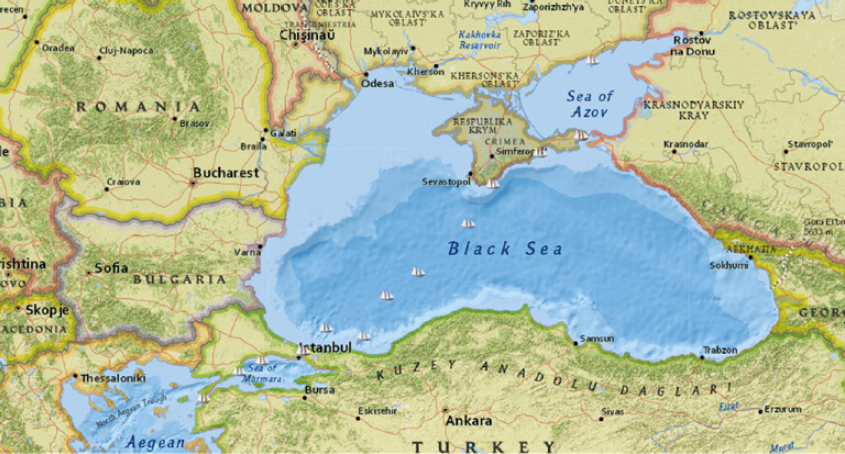
In the examined logbooks of sailing ships, the evidence shows that they operated mainly within the Mediterranean and Black Sea waters, reflecting the main trading pattern of the Greek-owned shipping industry. The most typical examples following this pattern are the two brigs Coundouriotis and Eleni Koupa, both owned and operated by Ioannis and Stamatios Kaloyannis from Hydra.7 Both sailed almost the same routes, especially from Berdyansk to Marseilles, indicating the business network of the Kaloyannis firm with these ports (Table 13.2).
Routes of the Coundouriotis and Eleni Koupa
Source: processed data from the logbooks of the respective ships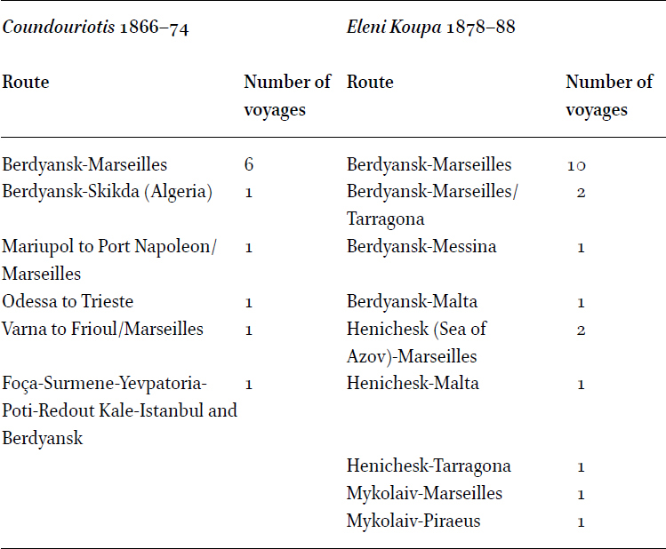
The Coundouriotis in eight years sailed six times from Berdyansk to Marseilles, while the Eleni Koupa in ten years had even a greater dependency on Berdyansk and the Sea of Azov, by sailing fifteen times from Berdyansk, three from Henichesk, in the north-western corner of the Sea of Azov, and only twice outside of it, from Nikolayev (today Mykolaiv). Marseilles was for both ships the most frequent destination (Maps 13.1 and 13.2).
Routes of the brig Coundouriotis 1866â1874
Routes of the brig Eleni Koupa 1878â1888
The Asimoula on the other hand, a 307-ton barque owned by Demetrios Katsoulis, a traditional ship owning family of Galaxidi,8 despite also sailing throughout the Mediterranean over three years, never sailed the same route twice. She sailed from Berdyansk to Catania and to Malta, from Batoum to Istanbul and to Berdyansk, and then to Marseilles. She also sailed from Batoum to Trieste, from Varna to Marseilles, from Sulina to Marseilles, and one interâMediterranean voyage from Marseilles to Alexandria-Limassol and from there to Tarragona (Map 13.3).
The Skopelos-built and owned brig the Stratigos Favieros represents a rather different case of trade strategy. The ship sailed the usual Black Sea- Mediterranean routes, but also went to Britain and was engaged in West African trade as well (Map 13.4). The Stratigos Favieros sailed from seven different Black Sea ports to Marseilles: Sevastopol, Berdyansk, Mariupol, Yeysk, Varna (twice), Burgas, and Constanta. She also sailed from Taganrog to Venice and from Yeysk to Barcelona. Outside Azov, she sailed once from Mykolaiv to Torre Annunziata, from Varna and the nearby Balchik to Livorno, and from Braila to Venice and Trieste. In September 1878, she also sailed from Mariupol to Falmouth with cereals and back via Cephalonia to Trieste carrying coal. This was to become the typical route-cargo pattern (Black Sea to north-western Europe with cereals; Britain to the Mediterranean with coal) in the following years for both sailing ships and cargo steamers, as we will see below in the cases of the Greek steamers of the late nineteenth and early twentieth century.9
Routes of the brig Stratigos Favieros 1876â1889
The involvement of the Stratigos Favieros and Theofania (see below) in West African trade was not an exception. Other Greek ships of that period were also engaged in this trade. The Stratigos Favieros made four round voyages from Marseilles or the nearby Port Napoleon, to carry mainly peanuts and secondarily palm kernels. These raw materials were necessary for the soap industry of Marseilles, for the production of peanut oil and palm oil and their mixing with olive oil, the main raw material for soap making, of which there was a shortage already from the 1830s. French enterprises that controlled the production and transport of these materials in West Africa already from the 1840s also had a shortage of French vessels, and thus often chartered foreign ones, among them mainly Greek, Italian, and British ships.10 The Stratigos Favieros sailed back and forth always between October to April, which coincided with the period of the harvest and transport of peanuts. The first voyage went from Marseilles to Benty in Guinea between November 1876 and May 1877 carrying salt on the outward leg. The other three voyages were carried out consecutively from October 1880 to February 1882. On two of them, the ship sailed from Port Napoleon/Marseilles respectively to Gorée Island, a few miles south-east of the Dakar Peninsula in Senegal, where it unloaded part of its cargo, consisting of salt and other merchandise. It then continued south to Rio Nunez in Guinea, a place where several French trading stations were established, and loaded peanuts and other goods for Marseilles.11 For the remaining voyage in 1881 it sailed to Gorée and Rufisque, opposite the peninsula of Dakar, where it loaded peanuts bound for Marseilles (Map 13.5).
Loading ports in West Africa of the brig Stratigos Favieros
A similar story is that of the 232-ton brig the Theofania built and registered in Spetses in 1865, and owned and captained by Anargyros V. Komnas. During the documented period of the logbook, 1873â76, the ship followed a different trade route pattern compared to most Greek ships of the period. In fact, the Theofania, for three consecutive years, sailed only once in the Mediterranean (a voyage from Marseilles to Sfax, in Tunisia) and never to the Black Sea. Instead, she sailed across the northern Atlantic, chartered in British ports, and Marseilles to West Africa (Sierra Leone, Rio Nunez, Brass River in Nigeria and Gabon), to the Demerara River in Guiana, and to Philadelphia in the USA (Map 13.6).
Yet, the first Greek-owned cargo steamers during this period seem to follow similar trade routes to most of the sailing ships. The Thiresia, was a rather small steamer, 580 tons, built in 1869 in Newcastle, and bought second-hand in 1887 and registered in Piraeus by the Istanbul-based firm Foscolo & Mango. During its two years of operation (1888â90) recorded in the logbook, the ship sailed exclusively within the Mediterranean and the Black Sea (Map 13.7). The ship operated mainly from Danube ports, Braila, Galatz, and Sulina to Marseilles (three times), Algiers (twice), Savona (twice), Genoa, Naples, and Barcelona, and from Taganrog in the Sea of Azov to Patras (twice), Messina, Trapani, and La Goulette in Tunisia. She made only a few voyages outside this pattern; once from Balchik to Genoa, from nearby Pomorie to Marseilles, from Novorossiysk via Mersin also to Marseilles, and from Åarköy in the Sea of Marmara to Sète.
Routes of the steamer the Thiresia, 1888â1890
The steamer Demetrio S. Schilizzi on the other hand, also owned by Foscolo & Mango, and newly-built in 1893 in West Hartlepool, based on a logbook and account books of the period 1895â90 sailed to far wider seas (Table 13.3). The Demetrio S. Schilizzi, 1277 tons, had twice the capacity of the Thiresia and sailed most of the time between the Mediterranean and Black Sea ports. However, she also sailed to northern Europe, Rotterdam, the UK, European Atlantic ports like Oporto, Lisbon, and Bilbao, and as far as Buenos Aires and Rio de Janeiro. This pattern of trade routes between the Mediterranean/Black Sea and northern Europe/the UK, and occasionally to ports on the other side of the Atlantic, became the norm in the following years for Greek cargo steamers.
Voyages of the steamer Demetrio S. Schilizzi
Sources: processed data from logbook and account books found in
The evidence from two steamers that operated in the first decade of the twentieth centuryâthe Leonidas and Andriana, both owned by the Andros shipowner Alkiviadis Embiricos (based in Braila), and built by Short Brothers in Sunderland in 1896 and 1906 respectivelyâcorroborate this trade route- pattern (Maps 13.8 and 13.9). The Leonidas carried cereals mainly to north-western European ports: Antwerp (three times), Rotterdam, Amsterdam, Birkenhead, and London (all once), from the ports of Azov, Taganrog, Akhtari (both twice) and Heniches`ka (once), from the Danube, Galatz and Braila (both once), and from Novorossiysk and Burgas. She always returned from Cardiff with coal to Italian ports: Savona (three times), Naples (twice), Torre Annunziata, Genoa, and Venice. During the two examined years she made only one round trip on the old Mediterranean/Black Sea route from Taganrog to Marseilles, and from there to Novorossiysk. The Andriana in a year and a half carried out diverse voyages, but always within the pattern. She carried cereals to Rotterdam only three times from the Black Sea ports of Galatz, Braila, and Taganrog. Instead, from September 1908 to April 1909 she made five consecutive round trips from Barry (three times), Newport, or Penarth to the Italian ports of Livorno, La Spezia, Brindisi, Naples, and Venice.
Routes of the steamer the Leonidas 1904â1906
Routes of the steamer the Andriana 1908â1909
The last stage of the expansion of Greek-owned steamers before the Second World War came in the 1920s with their involvement in the routes between Britain and Rio de la Plata. This development occurred because of the declining presence of the British fleet in this market after the shortage of vessels during the First World War, the consequent rise of the freight rates, and the reconstruction and growth of Greek-owned tonnage after its heavy losses during the war.12 The evidence in navigation of this new trading route comes from the steamer the Konstantinos Lemos, a second-hand ship of 2,845 tons, built in 1906 and owned by Panagos C. Lemos. The Lemos is another remarkable Greek ship owning family from Oinousses, a tiny island next to Chios, a very important maritime community that managed successfully to shift to steamers.13 The Konstantinos Lemos, made its first two round trips from September 1924 to July 1925 from Penarth and Falmouth to Buenos Aires. Then, up to 1927, continued to sail on the usual routes between the Black Sea/Mediterranean and northern Europe/the UK, from Novorossiysk, Odessa and Poti to Rotterdam (three times), Bremen and Hull, making only one round trip on the traditional Mediterranean/Black Sea route (Map 13.10). It is the first of the examined ships that in almost three years of activity never touched Marseilles and sailed only twice to Italian ports: Livorno and Genoa.
Routes of the steamer Konstantinos Lemos 1924â1927
3 Duration of Voyages
The duration of the voyage was subject to many factors: the sailing season, the particular weather conditions on each voyage, the state of the ship, and the seamanship of the captain, officers, and crew. For sailing ships, the above factors had an even greater impact on the performance of the vessel and the duration of the voyage. The analysis of sailing ship voyage duration and conditions will centre on Marseilles, which was the most frequent port of departure and destination, not only of the sample of the examined sailing ships but also of most of the Mediterranean ships involved in the Black Sea trade and beyond. In the 1880s, Marseilles was the fifth port in the world both in terms of registered tonnage and in ship traffic behind London, New York, Liverpool, and Cardiff.14 The two main trading areas of the examined sailing ships in relation to the port of Marseilles are the Black Sea and West Africa. Despite the latter being far less important for Greek shipping, it may offer a useful point of comparison with the Black Sea, and is also a route that seems to have been far more frequented by Greek ships than the current research so far has demonstrated. It is worth noting that despite the impression given by the map, the distance from the Sea of Azov ports like Mariupol and Berdyansk to Marseilles is even greater than from the Dakar ports, Gorée and Rufisque, and a little shorter than the central Black Sea ports like Mykolaiev and Sevastopol (Table 13.4).
In fact, the fastest route of the Stratigos Favieros from the Black Sea was the 2,242 nautical miles voyage from Sevastopol to Marseilles, in May 1878, in 28 days, whereas the 2,439 miles route from Marseilles to Gorée, in March 1881, was completed in 21 days. The longest West African voyage was the 3,014 miles from Benty to Marseilles in 71 days in early spring 1877, whereas the two consecutive round voyages between the Dakar ports Gorée, Rufisque, and Marseilles from February 1881 to February 1882, was made on average in 37 days. On the route from Marseilles to Rio Nunez, the Theofania took 42 days on the outward passage and 76 on the homeward one, this latter leg being the most difficult. The Theofania also sailed from Swansea to the Brass River, a distance of 4552 nautical miles (nm), in 55 days, and on the return passage from Gabon Estuary to Falmouth, 4,643 nm in 82 days. This same ship also sailed the 5629 nm from Dunkerque to Demerara in 127 days in the winter of 1875, while on the return voyage to Liverpool, it did the 5500 nm in the summer of the same year in only 45 days. Distance and duration were not proportionate in navigation and in the enclosed seas it seems that often conditions affected the duration of the voyage more than in the oceans. In fact, the Stratigos Favieros, on five voyages from the Black Sea ports of Berdyansk, Seavastopol, Constanta, Varna and Burgas to Marseilles, took on average 55 days, the longest being from Varna in the winter of 1884 that took 73 days. Similar records from Black Sea ports are registered for the other ships too. The Eleni Koupa in twelve voyages from Berdyansk to Marseilles needed on average 58 days; the Coundouriotis for the same route in seven voyages needed 65 days; while the Asimoula took 42 days from Berdyansk in summer 1884, and 70 from Varna in winter 1882 (Table 13.5). These figures show that the Black Sea and the Mediterranean, despite being closed seas, presented special conditions and dangers that affected the duration of voyages. A correct assessment of voyage duration between the two areas in comparison, requires a distinction between winter and summer navigation. Winter navigation is considered to be from November to March and summer from April to October, valid for the northern hemisphere. Practically, the ports of Azov were closed to navigation from the end of November to the end of March/beginning of April due to ice.15 In fact, the latest departure from Azov is recorded at Berdyansk on 6 November 1870 by the Coundouriotis, while the earliest recorded arrivals into Azov were those of the Coundouriotis and Eleni Koupa, again at Berdyans, on 29 March 1874 and 27 March 1888 respectively. In the Black Sea ports outside Azov, ice had less severe consequences, like in Odessa where the port was frozen for shorter periods during December, January, or February.16 Thus, the Coundouriotis was able to depart from Varna to Frioul on 16 November 1871 and from Odessa to Trieste on 29 November 1872, as well as the Stratigos Favieros on three occasions in November from Varna, Balchik and Mykolaiv in 1883, 1884, and 1885 respectively. The severe conditions and the almost complete absence of trade in most of the Black Sea ports in winter may lie behind the strategy of the Asimoula to work from September 1884 to April 1885, namely the winter, between Marseilles, Alexandria, Limassol, Tarragona, Zakynthos, and Istanbul before departing again for Berdyansk for the usual Black Sea-Mediterranean trade route. However, the ship that epitomized this strategy of profiting in the winter pause in the Black Sea, was the Stratigos Favieros. All of her four round voyages in West Africa took place between October to April, which was the period of the peanut trade. The Stratigos Favieros in two more winters between 1877â78, sailed from Marseilles to Volos, Preveza, Lefkada and Salaora before departing for Sevastopol, where it arrived in early April, and in 1879 when it arrived at Falmouth on 4 February from Mariupol, and returned to Cephalonia on 18 April in 66 days, before sailing to Istanbul for the Black Sea.
Duration of passages in days to and from Marseilles
Source: processed data from https://isl.ics.forth.gr/FastCatTeam/templates/ship_map.html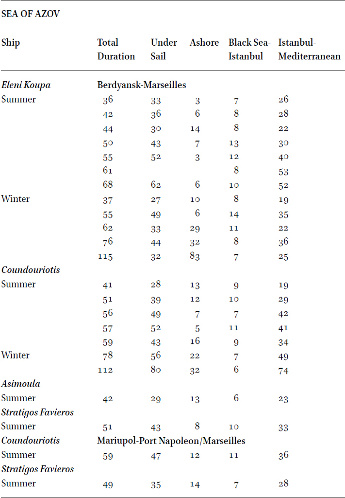
The passage from Berdyansk and Mariupol to Istanbul in the four sailing ships17 took, on average, nine days, while from the ports outside Azov, Mykolaiv, Varna, Burgas, Sevastopol, and Constanta, approximately three days. In 1845, sailing ships from Odessa took on average six days to get to Istanbul and from the harbourless Taganrog, in the far north-east corner of the Azov Sea, 23 days.18 The ships stayed ashore on average sixteen days, most of which were usually in Istanbul, the inevitable route and the great maritime centre, or to nearby anchorage in the Bosporus, usually Büyükdere, for bureaucratic procedures, commercial transactions, repairs, supplies, crew discharge, and new recruits.19 In 1845, the average stay at Istanbul was three times less (5.6 days) than the much longer period of stay from the mid-1860s onwards, probably due to the increased ship traffic in the growing Black Sea trade routes.20 Ships also had to usually stay for shorter periods at Kerch, when they departed from Azov ports, due to the shallowness of the water, which demanded the use of lighters and barges, that not only caused delays and raised transport costs, but also led to a frequent loss of cargo stolen from the lighters in the Yenikale.21 Sailing ships also often had to stay at Mediterranean anchorages due to weather conditions, usually at Malta, Messina, or Cagliari in the middle of the Mediterranean passage, and at some French anchorages before their arrival at Marseilles, more frequently at Hyères Island, but also at Toulon, Frioul, Cassis, or Cannes.22 Sometimes they also stopped at their homeports like Hydra for the Coundouriotis and Eleni Koupa, or Skopelos for Stratigos Favieros for technical, business, or social reasons, and would sometimes spend much of the winter there before starting a new voyage. The four sailings ships performed the longest leg of the voyage from Istanbul to Marseilles on average in 35 days, which almost coincides with the 1845 ship data.23
In Table 13.6, the performance of the four sailing ships is compared with the data on the arrivals of brigs to Marseilles from specific ports in 1875; all but one of the samples are brigs and the only barquentine, the Asimoula, is closer to a brig in sailing performance than to a full-rigged ship. In the best documented route, Berdyansk/Mariupol-Marseilles, in the summer, the average duration of three out of the four ships is slightly above the general average seen in the 1875 data. Only the Asimoula performed much better in her only voyage of this category. In the winter, the Coundouriotis almost matches the 1875 average, but the Eleni Koupa in this period performed far better, with an average of 69 days. On the Burgas/Varna-Marseilles winter route, all ships took less time than the 1875 general average, especially the Coundouriotis, where her only voyage from Varna took 49 days.
Voyage duration in days. In parenthesis the number of voyages
Source: Processed data from the newspaper Semaphore de Marseilles and from the logbooks of the four Greek sailing ships
The advent of cargo steamers reduced dramatically the duration of the voyages, and drastically changed the navigation patterns. In 1875, the time employed by steamers from Azov ports to Marseilles was three to four times less than the summer performance of sailing vessels, and almost more than six times less than their winter performance. Similar results can also be seen from other important ports like Odessa, which concentrated the bulk of cargo steamer traffic to Marseilles. Twenty years later, the duration further improved by two to three days from the Azov ports, and up to five or six days from the rest of the Black Sea (Table 13.7).
Duration of passages of steamers from the Black Sea to Marseilles. In parenthesis the number of voyages
Source: Delis, âNavigating perilous waters,â Table 4, 22â23
The steamer Thiresia, in service almost contemporarily with the sailing ships operating between the Mediterranean and the Black Sea, needed only nine and ten days, respectively, from Braila and Galatz to Marseilles in 1888; one of the Braila voyages was made in December of that year after the breaking of the ice in the Danube. The voyage from Pomorie (Anchialos), on the south-eastern Bulgarian coast, to Marseilles, in January 1890, also took nine days, which is between five-and-a-half to eight times less time than that required by the sailing vessels from Burgas and Varna to the same destination in winter (see Table 13.4). This performance is even better than the average from the data on 1895 steamers working from the Black Sea to Marseilles (see Table 13.7).
The much larger and more modern steamships the Leonidas and Andriana, operating almost two decades after the Thiresia, no longer carried cereals to the Mediterranean but rather to North Sea ports. They managed to cover the distances of almost 4,000 to 4,500 nm from the Black Sea to Rotterdam, Amsterdam, Antwerp, and London in twenty days on average. In the return voyage from Cardiff, or nearby Barry, Newport and Penarth (where the steamers always went after discharging their cereals in North Sea ports for repairs and supplies), carrying coal mainly to Italian ports, both the Leonidas and Andriana showed surprising regularity and precision. In fact, they covered the almost 2,400 nautical miles on average in ten days, exactly half the time they needed to cover the twice the distance voyage from the Black Sea to the North Sea ports: twenty days. Only Venice, which is slightly more than 3,100 miles from the coal ports, needed five to six days more (Table 13.8).
Duration of the voyages of the steamers Leonidas and Andriana
Source: Processed data from the logbooks of the Leonidas and Andriana
The Konstantinos, a steamer built in 1906 like the Andriana, but larger at 2,845 nrt, sailed in the 1920s the same distances of 4,000 to 4,500 nautical miles from the Black Sea to the North Sea ports at a slower speed, taking two to five more days to get to its destination, as she was almost twenty years old. The ship sailed the northern Europe-Mediterranean routes in almost the same time as the then new Andriana twenty years earlier, while it had the best performances on the Atlantic route from the UK/northern Europe to Rio de la Plata, covering a distance of 7,500 to 8,000 nm in a little more than a month (Table 13.9).
Voyage duration of the steamer Konstantinos
Source: the logbook of the Konstantinos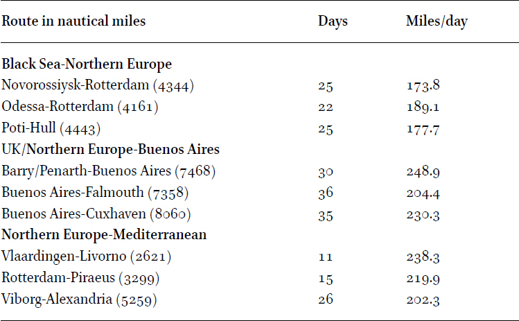
4 Navigation Patterns and Conditions
Navigating to and from the Black Sea was very demanding due to the special sailing conditions in confined waters like the Dardanelles, the Sea of Marmara, and the Bosporus. Sailing ships bound to Istanbul had to wait in Tenedos or Troada for favourable southern winds to enter the Dardanelles, as occurred with the Asimoula in April 1883 in a voyage from Valencia to Batoum, when the ship waited ten days, first in Tenedos and then in Cape Giaour further north, before entering the channel.24 When in the Dardanelles, ships had to face the prevailing north and north-east winds and again had to wait for a favourable wind that would enable them to shift from one anchorage to another up to the Sea of Marmara.25 This is exactly what the Stratigos Favieros faced in September 1888 with adverse north-west/north/north-east winds in a trip from Marseilles to Braila, where it had to anchor at BeÅik Bay then at White Cliffs before she was towed at Nagara Point, then was anchored again up at Lampsakos Bay before departing with a favourable southern wind (see Map 13.11).
Crossing the Dardanelles
Source: Delis, âNavigating perilous watersâ, 4
The data from the sailing ships shows that in their efforts to transverse the channel, they used different anchorages always on the Asiatic side of the Dardanelles, more frequently at BeÅik Bay (Stratigos Favieros, Eleni Koupa, and Coundouriotis) and White Cliffs in the southern part (Coundouriotis, Stratigos Favieros, Asimoula), and at Lampsakos (Stratigos Favieros, Eleni Koupa, Coundouriotis), and Cherdak Point in the northern entrance (Eleni Koupa, Coundouriotis). Another important delaying factor was the sanitary and administrative procedures to enter and leave the channel. The central health office was at Chanak Kale, but ships could also obtain pratique at Seddul Bahr, the northern entrance of the Dardanelles from the Aegean Sea, at White Cliffs and at Gallipoli or Lampsakos. In fact, the Coundouriotis, Asimoula, and Stratigos Favieros used to stop for these procedures most of the time at Chanak Kale, the Eleni Koupa at Nagara Point, while the Stratigos Favieros and Asimoula also stopped at White Cliffs. At Nagara Point and Chanak Kale, ships also used to call for a steam tug service when facing adverse winds.
The passage of the Sea of Marmara was the easiest of all tasks of the voyage since the weather was usually good, something which is also reported in most of the weather observations in the logbooks of the sailing ships. Similarly, as in the Dardanelles, north-east winds are prevalent the whole year, but in autumn and early spring the south and south-east winds are frequent, fresh and the weather clear.26 According to the sailing shipâs logbook data most of the time ships passed by Marmara Island in the middle of the enclosed sea. However, often they followed the northern coast in combination with or without Marmara Island. All the ship data showed that they passed the same locations namely: Marmaraereglisi (Herakleia), Silivri, Gaziköy, Büyükçekmece, and Küçükçekmece and they only once sailed on the southern side (see Map 13.12). Ships usually needed one, or a maximum of two, days to cross the Sea of Marmara passing by one or two of the above-mentioned points. Despite the good weather conditions, however, the Coundouriotis, being the oldest of the sailing vessels, on certain occasions needed four days to cross the Sea of Marmara, taking one day from one location to another.
Sea of Marmara anchoring and passing points
The last challenge for sailing ships bound for the Black Sea was the Bosporus channel, 17 miles long and from 0.4 to 1.5 miles wide. The examined sailing ships usually after crossing the Sea of Marmara anchored at Samatya (Psamatheia), south-west of Istanbul. From there they often had to be towed by a steam tug to get to the Bosporus due to the prevailing NE winds as well as of the strong current of the channel, unless south or south-west winds blew.27 In the Bosporus they anchored at Büyükdere before setting sail for the Black Sea.
Ships from the Bosporus bound for the ports of Azov, according to the sailing pilots (Map 13.13), sailed with the prevailing east to north-east winds in the eastern part of the Black Sea, and in order to avoid the adverse current coming from the southern shores of the Crimea, had to follow the course along the Anatolian coast up to Sinope before turning north to the Straits of Kerch. However, the data from the logbooks of the sailing ships offers a different picture. Except on very few occasions, all of them headed from the Bosporus to the south and south-east coasts and anchorages at Crimea before entering the Straits of Kerch. More frequently, the ships headed to the capes of Aytodor, Ayudag, and to Theodosia in eastern Crimea, and occasionally to Cape Sarych and to Balaklava in the south. Most of these routes followed a straight north-east direction to the Crimea, as illustrated in Map 13.14, but there were also a number of alternative courses.
Navigating the Black Sea
Source: Delis, âNavigating perilous watersâ, 10
The Eleni Koupa: Marseilles-Berdyansk-9 March 1886â22 April 1886
In the most frequent of these alternative courses, ships sailed from the Bosporus in a north-westerly direction along the Bulgarian coast and between the 43° N and 44° N parallels, and at the 28°E and 30°E meridians turned in a north-east direction towards Crimea (Map 13.15). The Stratigos Favieros, in the three-recorded voyages to the Azov, always followed this course,28 while the Coundouriotis did that in only two out of ten, and the Eleni Koupa in five out of 16, recorded passages. The Eleni Koupa attempted three more times the western course, but due to adverse weather and winds off the Bulgarian coast had to return to a south-east direction, and then headed up in a north-east direction to reach south-eastern Crimea.29 The Coundouriotis once and the Asimoula in two passages from the Bosporus to Azov, followed an opposite eastern course to Kerch On the first passage of the Asimoula, the ship, facing north-east winds, took an almost straight north-east course to Anapa, a small port north of Novorossiysk, and 20 miles from the shore headed to Kerch. On the second journey from Istanbul to Berdyansk, it sailed with south-east winds in a north-east direction up the middle in a straight line between Sinope and Theodosia (43° N and 44° N parallels, 34°E and 36°E meridians) before heading north to Kerch (Map 13.15).30
The Stratigos Favieros: Torre Annunziata-Yeysk 21 February 1885â11 April 1885; the Coundouriotis: Istanbul-Berdyansk 13 September 1867â7 October 1867 (highlighted); and the Asimoula: Istanbul-Berdyansk 2 April 1885â13 April 1885 in the centre of the map
Ships bound for Odessa, already from the 1830s, according to pilots, followed a north-westerly direction to Cape Kaliakra, then went north-east to Serpent Island off the mouth of the Danube and then to Cape Fontana, aided in case of adverse weather by shelters in Cape Iniada and the Gulfs of Bourgas or Varna. An alternative course in the later part of the nineteenth century, in order to avoid the often-frequent northerly winds, was to head for the Crimean shore taking advantage of the north-east and east-north-east prevailing winds (Map 13.13).31 The Eleni Koupa has two recorded voyages to Mykolaiv or Nikolayev; on the first one, during October 1878, it followed an intermediate course compared to the above-described ones, in the middle of the western basin, under strong north-west and later south-west winds and rain. In the second voyage, instead, it followed the suggested north-westerly direction, covering, in one day between 28 and 29 March 1879, 191 miles, before passing the Yerna Lighthouse and anchoring the following day in Ochakov.32 The Asimoula in August 1885 bound for Sulina, took a distant off shore course, but near Constanta, due to strong north-west winds, switched to an easterly course for two days before managing to set a north-west course again to her destination.33 The only two recorded voyages to the east coast of the Black Sea, are recorded by the Asimoula, bound to Batoum. It shows that the ship, in both voyages, followed the course indicated by the pilots (Map 13.13) where it faced calms and light winds. However, on a similar route, FoçaâSurmene, in winter 1869, the Coundouriotis sailed in a north-easterly direction, and between 43° N and 44° N and 32°E and 34°E switched to a south-easterly course up to its destination (Map 13.16).
The Asimoula: Istanbul-Îatum 12 May 1883â22 May 1883; the Coundouriotis: Foça-Surmene 5 February 1869â2 March 1869 (highlighted)
On the return voyage, from the Black Sea ports to the Bosporus, ships followed the same reverse patterns. From the Straits of Kerch exiting the Sea of Azov, most of the routes of sailing ships headed straight in a south-westerly direction to the Bosporus with little variation according to the weather (Map 13.17). The Stratigos Favieros again is the exemption, by taking the western route along the Bulgarian coast in its three passages from Berdyansk, Taganrog, and Yeysk to the Bosporus. In the first one from Berdyansk, she headed to the Bulgarian coast and sailed along down to the Bosporus. In the second she sailed from Cape Aytodor in south-westerly direction up to just off Varna, covering 213 miles in one day, and two days later anchored at Büyükdere. In the third voyage from Yeysk she took an oblique south-westerly course up to off Burgas, when she turned south-east to Büyükdere. The Coundouriotis also on two occasions followed the western course, in both passages heading to Cape Kaliakra, north of Varna, and in the second passing off Sozopol and Cape Iniada before entering the Bosporus, probably unable to beat the blowing southern winds.34 In all recorded passages from the ports of the northern or western coast of the Black Sea (Mykolaiv, Odessa, Sulina) the ships followed the western route to the Bosporus, as defined in Map 13.13.35 Ships bound for Istanbul from the eastern coast, like the Asimoula in the only recorded voyage from Batoum, had to sail counter-clockwise with light south-west and then north-west winds up to southern Crimea before taking the usual south-west course to the Bosporus (Map 13.18). The ship followed the current formed by the rivers of the northern coasts, which travels along the Anatolian coast and then north to the Caucasian coast up to the strait of Kerch (Map 13.13).36 The Coundouriotis also followed the same pattern but on a straighter course to southern Crimea in her trip from Surmene to Yevpatoria (Map 13.18).
The Coundouriotis: Berdyansk-Marseilles 19 September 1873â30 October 1873; the Stratigos Favieros: Yeysk-Barcelona 30 April 1885â2 July 1885 (highlighted)
The Asimoula: Batoum-Istanbul 8 July 1883â23 July 1883 (highlighted); and the Coundouriotis: Surmene-Yevpatoria 3 April 1869â8 April 1869
Ships entering the Aegean from the Dardanelles sailed in a south-west direction from Tenedos or off western Mytilene, occasionally making short stops at homeports (the Stratigos Favieros at Skopelos; the Coundouriotis and Eleni Koupa at Hydra) then passing Cape Kafireas, the Mirtoan Sea, and the southern Peloponnese, before entering the open Ionian Sea up to Malta. The analysis of this last leg of the return voyage will only consider the routes to Marseilles since this port is the most frequent destination and the only port for which the examined ships followed variable navigation patterns. In the summer, sailing ships from the Black Sea bound for Marseilles, usually sailed through the Strait of Sicily heading to Cape Spartivento in south Sardinia, passing either by the southern Sicilian coast, amid the channel, or, as in most of the recorded cases, via Cape Bon in Tunis. From southern Sardinia ships continued up north to the last open leg to Marseilles (Map 13.19). In the winter, due to the prevailing strong westerly winds, sailing ships bound for Marseilles passed through the Straits of Messina and then north of Corsica (Map 13.19).37
Typical summer/winter routes. The Coundouriotis summer route: Berdyansk-Marseilles 14 June 1872â4 August 1872 (highlighted); the Eleni Koupa winter route: Berdyansk-Marseilles 20 October 1879â14 December 1879
This latter route, however, was not recommended in the summer due to calms and light winds east of Corsica and in the Straits of Messina.38 However, on certain occasions, captains opted for the exact opposite of the recommended route in the specific season. The Eleni Koupa in November 1884, despite facing adverse north-westerly winds and waves in Malta and in the Strait of Sicily, continued through the summer route sailing west of Sardinia.39 The opposite also occurred sometimes on all of the examined ships, which, due to weather difficulties, took the winter route during the good season.40 The Asimoula and Stratigos Favieros in particular in these occasions, faced bad weather after Messina northward along the Italian coast, especially the latter, which suffered damage on the ship and the cargo from the water that entered the vessel due to strong south-west winds, and had to stop for three days at Genoa before departing for Marseilles. Apart from the two above-described established routes, ships followed alternative ones when encountering difficulties en route, like when in the Strait of Sicily, instead of heading west of Sardinia and continuing up through the Tyrrhenian Sea. More frequently in this case, ships followed a route northward of Corsica. The Eleni Koupa in December 1887, due to strong south-west winds and big waves in the exit of the Strait of Sicily, headed to the eastern side of Sardinia where she faced stormy north-west winds, sleet and very big waves along the eastern coast of Corsica that damaged the cargo and ship (Map 13.20). The Coundouriotis in a similar situation was pushed into the Tyrrhenian Sea by south-west winds at Maritimo Island near Trapani, and then into the Ligurian Sea until Saint Tropez, and faced very strong south-west winds and great waves, with damage to ship and cargo.41 Another variation to this route was followed again by the Eleni Koupa in January 1887, when off Marsala, she turned to the middle of the Tyrrhenian Sea, and directly between Latina and the Bonifacio Straits faced stormy north-east winds and huge waves that pushed her through to the Bonifacio Straits, reaching the south-western coast of Corsica, and covering in a single day a distance of 133 miles (Map 13.20).42
Alternative routes. North of Corsica the Eleni Koupa: Berdyansk-Marseilles 13 October 1887â28 December 1887; through the Bonifacio Straits (highlighted): Berdyansk-Marseilles 9 October 1886/â1 February 1887
The Stratigos Favieros, also in the Mediterranean passage, followed a different pattern in almost half of her voyages to Marseilles. In five out of six instances in which the ship followed the route west of Sardinia, she sailed in a north-west direction close to Menorca and to the Spanish coast, approaching the Gulf of Lions and Marseilles from the south-west (Map 13.21), which none of the other examined ships did in the western route, simply following, as indicated, a straight northerly course. Also in some of these voyages, the ship faced strong north-west, south-west and northerly winds in the Strait of Sicily, between Lampedusa and Pantelleria (which is a frequent phenomenon), and had to return to Malta or to southern Sicily anchorages (Cape Passaro) until the weather improved.43
The Stratigos Favieros: Berdyansk-Marseilles 18 June 1882â8 August 1882 (highlighted); Burgas-Marseilles 23 October 1882â18 December 1882
The second area of navigation is West Africa, in which the only available data comes from the Stratigos Favieros and Theofania. Sailing from Marseilles to West Africa must have been an easier and faster task than the return voyage. The Stratigos Favieros took on average 40.5 days to get to West Africa and 48 days on the return voyage, while the Theofania almost needed double the period of time on its homeward passage, namely 80 days on average against 39 on the outward passage. In the outward voyage, in the leg sailed along the Spanish Mediterranean coast and up to the Strait of Gibraltar, in all three recorded passages of the Stratigos Favieros, the ship faced more difficulties than in the Atlantic Ocean. In two of these outward voyages, both in October, the ship faced adverse westerly winds in the Spanish Mediterranean coast, and in the 1880 voyage, strong eastern winds and heavy rain in Gibraltar.44 In the following October, the conditions were even worse and the ship had to make many manoeuvres to straighten her course all along the Mediterranean passage, and was in danger somewhere near the Straits of Gibraltar, a notorious area for violent southern gales and rough weather conditions.45 Once in the Atlantic Ocean, the ship in all of the three-recorded outward voyages passed between Madeira and the Canary Islands.46 Then, in the two October voyages of the Stratigos Favieros, passed west of the Canary Islands, and only on the March 1881 voyage did she pass between Tenerife and Gran Canaria, and in all three instances the ship sailed from the Canary Islands to Gorée with the prevailing favourable north winds making fast passages.47 A similar sailing pattern is also followed by the Theofania in two outward voyages from Swansea, in autumn 1873 to Sierra Leone, and in winter 1876 to Brass River (Map 13.22).
The Stratigos Favieros: Marseilles-Gorée 3 October 1880â4 November 1880 (highlighted); the Theofania: Swansea-Brass River 20 December 1875â13 February 1876
In the winter return voyage the two examined ships always sailed west of the Cape Verde Islands, then steered to a north-west or northerly direction up to between the 24° N and 30° N parallels, when she steered again to the north-east to Gibraltar, always passing north of Madeira and in any case west of the suggested itinerary of the sailing pilots (Map 13.23). The course of the ships during each voyage was subject to the North Atlantic trade winds (north-easterlies), their geographical limits changing every season. In the winter the trade winds extend from 40° 26â²N to 5° 41â²N east of the 35° W meridian, an area that corresponds to the middle of the coast of Portugal to the Sierra Leone basin, the average being at 28°N 8â² at the level of the Canary Islands. From July to September the limits shift north from 49° N 25â² to 19° N 19â² from Bretagne to the middle of Mauritania, the average being at 36°N 21â² at the latitude of Gibraltar.48
Winter homeward route. The Stratigos Favieros: Rio Nunez-Marseilles 16 December 1880â20 January 1881 (middle); the Theofania: Sierra Leone-Marseilles 28 December 1873â21 March 1874 (left); highlighted on the right is the pilotâs suggested itinerary
In spring and summer, a period that sailing ships had more difficulties because the trade winds reach farther north, the Stratigos Favieros in May 1881, in a voyage from Rufisque, after encountering north-east trade winds for three consecutive days reached the furthest north-west point of all her recorded voyages, between 30° N and 33° W, before steering north-east to Gibraltar under north winds.49 The ship sailed more west than the suggested itinerary for sailing directions for a voyage from Senegal to Gibraltar in May,50 and passed also west of the Cape Verde Islands, instead of the suggested course between the Islands and the African coast (Map 13.24). The Theofania at the end of June, July and August 1874, with the trade winds further north, under north winds, headed in a north-westerly direction far more west than the suggested itinerary. The ship reached its maximum north-western point at 39 W meridian and north of the 37 N parallel, while the suggested itinerary did not surpass the 31 W meridian and the 35 N parallel. Later the ship met favourable south-west winds to Gibraltar passing north of the Azores but again beyond the 35 W meridian and more north than the suggested itinerary, to meet with the suggested route only east of the Azores (Map 13.25).
Summer homeward route. The Stratigos Favieros: Rufisque-Marseilles 25 April 1881â2 June 1881. Highlighted is the pilotâs suggested itinerary, from Labrosse, The Navigation of the Atlantic, 64â66
Summer homeward route. The Theofania, Rio Nunez-Marseilles: 21 June 1874â5 September 1874. Highlighted is the pilotâs suggested itinerary, from Labrosse, The Navigation of the Atlantic, 64â66
The evidence for the return voyages shows that the ships never sailed between Cape Verde and Senegal as suggested by the sailing pilots of the period, but always westwards of Cape Verde along the northbound passage. In addition, the Stratigos Favieros always set an easterly course for Gibraltar far more south-east than suggested by the pilots, like on the voyage from Rio Nunez when she steered 230 miles south-east from the suggested point, saving a lot of time and distance (Map 13.24).51 Again, on the return voyage, the most difficult part was the passage along the Spanish Mediterranean coast. In late April 1877, the Stratigos Favieros, coming from Benty, faced stormy north winds off Valencia, and in May 1881, coming from Rufisque, variable strong winds and stormy weather, that put the ship at great pains, with water coming into the hold and fear for cargo damage.52
Steamers on all but one of the recorded voyages in the Mediterranean-Black Sea trade route, with Marseilles as a clearing or destination port, always passed through the Bonifacio and Messina Straits, before continuing from Bonifacio in a north-westerly direction to Marseilles or from Messina to the southern Peloponnese, and then once in the Aegean taking a north-east route to the Dardanelles.53 Only once did the Thiresia, on a voyage from Pomorie to Marseilles in 1890, after the Straits of Messina, follow the route north of Corsica and not through the Bonfacio Straits (Map 13.26).
The Thiresia: Galatz-Marseille 30 May 1888â9 June 1888; Pomorie-Marseilles 7 January 1890â16 January 1890 (highlighted)
In the very established route in the first decade of the twentieth century between the Black Sea and north-western Europe, steamers after Malta and Cape Bon sailed all along the North African coast up to Gibraltar. In most of the recorded cases, steamers, when in Algiers, headed far from the African coast towards Cape de Gata in the eastern entrance of the Gulf of Almeria, before entering the Straits, probably to avoid the eastern bound current along the African coast (Map 13.27).54 Exiting Gibraltar, steamers sailed along the Iberian Atlantic coast, following a straight north to north-east course, passing from the Isle of Ushant off Brest before entering the English Channel to Rotterdam, Amsterdam, or Antwerp (Map 13.27). After the discharge of the cargo in one of the aforementioned ports, ships were heading to UK ports, usually Cardiff, for repairs and supplies and for taking coal to the Mediterranean. From Cardiff, steamers headed in a straight southerly course along the Iberian coast passing Cape Villano and Cape Finisterre in Spain, Berlengas or Burling Islands and further south to Cape Roca before the mouth of Tagus in Portugal, and Cape St. Vincent before Gibraltar (Map 13.28). Once in the Mediterranean, steamers bound to north Italian ports, Genoa, Savona, or Livorno, steered a north-easterly course through the Balearic Islands (Map 13.28). Those bound to Naples or Torre Annunziata sailed far from the North African coast and south of Sardinia via Cape Spartivento, and those bound to Piraeus passed north of the Alboran Island and then, helped by the eastward current, sailed along the African coast up to Cape Bon, when they continued through Malta and the Sicilian coasts to the southern Peloponnese (Map 13.28).55
The Andriana: Galatz-Rotterdam 22 April 1908â11 May 1908
The Leonidas: Cardiff-Savona 3 August 1905â12 August 1905; the Andriana: Barry-Naples 4 June 1908â14 June 1908 (highlighted); the Konstantinos: Rotterdam-Piraeus 11 December 1925â27 December 1925
The Konstantinos, in the two round voyages from the UK to Rio de la Plata between September 1924 and July 1925, always had easier and faster passages on the outward leg. On both occasions from Penarth and Barry, the first in September and the second in January, the ship encountered stormy southerly winds, heavy seas, and big waves in the North Atlantic until she entered the trade winds zone, just before or along the Spanish coast, according to the part of the season.56 Once in the trade winds zone the ship encountered good weather until Cape Verde, passing, on the Penarth voyage, east of Madeira, off Gomera Island in the Canaries and east of the Cape Verde Islands (Map 13.29), whereas on the Barry voyage she followed a course west of Madeira and the Canaries and between Santo Antão and St. Vincent in the Cape Verde Islands.57 In the Penarth voyage, after Cape Verde, the ship exited the trade winds and crossed towards the South American coast under strong south-west winds for three days. Then on the South American coast up to Rio de la Plata (Map 13.29) the ship sailed under south-east winds and good weather, except between the 21°S and 23° S parallels, where she faced strong south-west winds, big waves, and stormy weather, an expected occurrence at this time of the year between Bahia and Rio de Janeiro.58 In the Barry voyage, the ship exited the trade winds zone after the equator at 2° S, 32° W, where she faced a strong south-east wind and stormy weather up to the latitude of Florianopolis, when the weather turned to favourable north-east prevailing winds that blow in January in that area up to Rio de la Plata.59
On both of the return voyages, the Konstantinos did not follow the suggested route of the sailing vessels bound for the English Channel, as indicated in Map 13.29, but rather the reverse route of the outward voyage, indicating the breaking of the limits with the previous technology of sail. In both passages from Rio de la Plata, the ship faced difficult weather. In the first journey bound for Falmouth in November 1924, she sailed under south-east winds, and stormy weather with big waves that put her in danger up to Rio Grande. These calmed to south-west winds and they then turned to the south up to Parangua until Rio de Janeiro, instead of the prevailing north-north-east winds that blow in the area in November.60 In Rio de Janeiro, the winds turned to the north-east, which prevailed this time of the year in the area.61 The weather alternated from stormy with big waves to calm, clear, and cloudy up to south of Cape Verde. On the second voyage to Cuxhaven, Germany, in June 1925, the ship sailed most of the South American coast, under strong south-east winds, stormy weather, big waves, and a rising temperature near the equator despite the strong wind. In both voyages, the ship in the trade winds zone also had troubling passages. On the Falmouth voyage, the ship made bunkering at St. Vincent and from there passed west of the Canaries and close to Madeira, up to the Portuguese coast, encountering alternatively storms with big waves and clear weather. Out of the trade winds, the winds turned to the south, south-west and south-east, with very rough and stormy seas and water coming onto the deck up to Falmouth.62 In the Cuxhaven voyage, the ship entered the trade winds at Cape Verde with stormy weather and big waves, stopped at Las Palmas on Gran Canaria for coal and water, and then continued under strong north-east winds, rough weather and waves coming onto the ship up to the Bay of Biscay, with damage and losses in the cargo of cereals and oxen. In the English Channel up to Cuxhaven she faced foggy weather and further difficulties with more losses of oxen.63
The Konstantinos: Penarth-Buenos Aires 6 August 1924â6 October 1924; highlighted the suggested course of sailing vessels bound for the English Channel, from: Labrosse, The Navigation of the Atlantic, 85
5 Events
The success of a voyage and the experience gained were very much subject to the day-to-day events that occurred, affecting the three interlinked categories of material and human capital at stake: the ship, the cargo, and the people on board. The most common problems for both sailing ships and steamers were the rough seas and big waves that put the ship in great danger. There was barely a voyage from the Black Sea where the Eleni Koupa and Coundouriotis did not meet such situationsâespecially in the central and western Mediterranean, and in all areas from the Ionian Sea to Marseillesâthroughout the year. Almost routinely, in those waters, big waves entered onto the hold, damaged the cargo of cereals, and often parts of the ship. Men pumped out the water for hours or even for days for it to come out mixed with grain. However, the Eleni Koupa faced the worse situation on two occasions. The first was at Cape Matapan in December 1881, in a voyage from Berdyansk to Malta, when the ship was flooded twice by waves to such an extent that the men believed they were about to be lost, but were saved only thanks to the intervention of âthe divine powerâ.64 On the return voyage from Malta to Piraeus in February 1882, the ship, again at Cape Matapan, could not sail against the stormy north-east winds that drove her towards the African shore damaging the rigging and sail, which forced the captain to throw 400 paving stones of the cargo into the sea so as to withstand the wind. However, the day before that, the worst happened when, eight miles from Cape Matapan, after midnight, the sailor Spyros Merkouris from Ermioni, working the topsail along with others, fell overboard and drowned in a stormy sea; his fellow seamen were unable to provide any help on a vessel running with the storm at 10 mph.65 However, even steamers faced similar situations. The Leonidas, in November 1904 on a voyage from Taganrog to Marseilles, near the Isle of Hyeres, was almost ungovernable due to strong north-west winds, stormy weather, and the impetuous sea.66 The Konstantinos had worse in the North Sea on a voyage from Leith to Viborg, when the ship remained ungovernable for eight hours and there was a danger to collide with the shore, until captain and crew decided to fill the hold with 400 tons of water in order to enable the vessel to steer against the wind.67 A month later in the next voyage from Viborg to Alexandria, along the Tunisian coast, the ship was again ungovernable, and had to throw out part of the cargo of timber to avoid disaster.68
Stranding was another danger that caused damage, delays, and further expense. The Coundouriotis was stranded on a reef in Yenikale in April 1874, and needed to unload part of the cargo in order to raise the shipâs draught, and required a steam tug to tow her due to contrary winds.69 Some 52 years later, the steamer the Konstantinos, near Kiel, was stranded on a reef and had to throw bunkers overboard to enable the ship to leave.70 Ship collision was another frequent accident at sea and in ports, with very serious financial and legal consequences. However, very few are recorded in the examined logbooks, such as that of the Coundouriotis, which was struck by an Italian ship 4â5 miles outside the Bosporus straits coming from the Black Sea. The captain and crew abandoned ship, jumping onto the Italian one, but after a while they noticed that their ship was not sinking, so they returned, took a steam tug to Therapia, where after a review by experts, it was decided to transport the cargo to another ship. A smaller part of the cargo that did not go onto the other ship was sold at auction in Istanbul, and the Coundouriotis was under repair there from 20 January to 9 March 1868.71 None of the examined ships faced a wreck. However, the Andriana in October 1908, north of Cape Villano in the Bay of Biscay, rescued sixteen of the 21 men of the sinking steamer the Provvidenza of Genoa, in a voyage from Cardiff to Tunis with coal, an event which was also reported in the Italian press.72
The correct and quick loading and unloading of the cargo was another determining factor for the success of a voyage. Captains of both sailing ships and steamers, in the examined logbooks, complained about delays due to festivities, national holidays, and other reasons. However, further danger and damage could come from the incorrect stowage of the cargo. This is what happened to the Konstantinos, in Poti, then in the Soviet Union, where the dockworkers had no experience of proper stowing of cottonseed, and threatened the first mate who supervised them and complained about their work. The freighters replied to the captainâs complaints by saying they were unable to impose themselves on the dockworkers because they were communists.73 The incorrect stowage of cargo and rough weather during a voyage up to Hull, the destination port, cost the ship very dear when, during the discharge, the temperature in the hold rose due to the injection of the cottonseed, and fire broke out in two holds, which took from 6â17 September 1926 to extinguish, at the same time as unloading was taking place, at great pains and raised costs.74 The Konstantinos also had another cruel experience carrying a cargo of 326 oxen from Buenos Aires to Cuxhaven, along with cereals, bones, tallow, and other goods in 1925. Along the Brazilian coast, the animals broke a tank from which the water from rough seas came in and rendered the potable water undrinkable. In the crossing of the Atlantic near the equator, the very high temperatures led to, perhaps in combination with the little available water, the death of eleven oxen (three more died during the rest of the voyage) and forced the ship to stop at Las Palmas on the Canary Islands to take on fresh water and coal.75 However, sailing vessels also had difficulties with dangerous cargo in rough waters. The Asimoula, carrying nitric acid from Alexandria to Limassol, in rough seas the glass containers broke, and the cargo burned the materials on the deck endangering the ship and the health of the men from the smoke and the strong smell.76
Political circumstances could also affect the course of the business of a ship. The Coundouriotis in December 1868, after remaining idle at Istanbul for three months due to the Cretan War and the broken relationship between Greece and the Ottoman Empire, was sold to K.A. Mavrogordatos, a Greek-in-origin Russian subject, who chartered her to the Ottoman government to carry salt from Foça to Surmene.77 The Stratigos Favieros also remained idle from 2 May to 6 October 1877 at Marseilles, paying the consequences for the 16 May 1877 constitutional crisis in France.78
Men must have suffered different hardships on board as well as ashore. Accidents must have been frequent, although not many were recorded in the examined logbooks. Among the recorded ones on the sailing vessels, falling from the masts onto the deck was the most common accident. On the Coundouriotis two such accidents were recorded: in the first, a sailor trying to lower the topsail in a stormy sea fell onto the deck and injured his hip and genitals; while in the second, another sailor broke his ribs.79 On the Eleni Koupa, off south Crimea, a sailor fell from the mainmast and injured his chest, while on two other occasions ashore, in Marseilles, a sailor was injured during the discharging of cargo, and in Büyükdere another sailor was injured while working a rope to move the ship in order to avoid a collision with other ships moored nearby. Both ended up hospitalised.80 However, a greater number of accidents are recorded on the Konstantinos. Most of them took place during works in port, either Buenos Aires or Novorossiysk, especially during the construction of partitions in the hold to accommodate new cargo.81 Other work accidents at port, like falling from the scaffold, being injured while painting the chimney, or being struck by objects while working or cleaning parts of the engine, are also recorded.82 Only two accidents are recorded at sea on the Konstantinos, both under severe weather conditions: one that swept the captain from the ladder; and the other that dislocated the first mateâs arm during night work with the sailors on deck.83 In all of these accidents, sailors received medical treatment, and in some of them they were hospitalised, or alternatively were accommodated in hotels (especially in Argentina) or in houses.
Illness was another great issue on board, especially since merchant ships carried no doctors. The most common was the cold, which was the case on the Konstantinos when four men fell ill when it arrived in Algiers after a bad voyage in December 1926; the same happened to another sailor at Odessa in March of that same year.84 Tropical or swamp fevers were another cause of illness in specific areas. The Stratigos Favieros, on the voyage from Rio Nunez to Marseilles in December 1880 and January 1881, experienced the serious consequences of typhoid fever in African waters. The crew was already stricken ashore during the discharge and loading of the cargo in the river, one falling ill after the other. The ship managed to depart, but the crew, nine men in all including the captain, kept falling ill, recovering, and becoming ill all over again, during the whole passage up to Marseilles. It is indicative of their sufferings that none of the crew, except for the captain, were included on the muster roll for the following voyage from Marseilles to Gorée and Rufisque.85 Five men from the Konstantinos also fell ill from swamp fever at Poti in August 1926, and followed a healthy diet and took quinine to recover.86 Chronic diseases also caused trouble, like with the first mate on the Andriana, who suffered cardiac problems and was relieved of his duties and fired in Andros, or the radio operator on the Konstantinos at Buenos Aires who felt ill in the head, almost fainted, and was hospitalized due to a chronic problem.87
The examined logbooks do not record a particularly high number of deaths, something which is also seen within the evidence for a fleet of windjammers in the late nineteenth and early twentieth centuries.88 We have already mentioned the only case of a sailor lost after falling overboard from the Eleni Koupa in a gale. But there was also a Dimitrios Ant. Vogiatzis, a seaman of the Stratigos Favieros, who fell ill with a cold near the coastal Bulgarian village of Stagouni, near Berdyansk, walked with the captain for an hour to visit the villageâs doctor who diagnosed âinflammation of the intestinesâ. The captain suggested that the sailor should stay in the village for treatment, but neither he nor the villagers welcomed the idea, and he returned to the ship where he died nine days later. The captain reported the death to the local authorities and buried the sailor there, his belongings consisting of work clothes, a knife, two razors, and two drachmas.89 Tropical diseases were also lethal for the captain of the Theofania, Anargyros V. Komnas. The ship was discharging at Brass River, Nigeria, where most of the crew fell ill, and later the captain as well, who felt a headache and angina (chest pain or pressure). He died the following day, and was buried in the nearby village, and his son took command of the ship.90
Infringing and offensive or violent behaviour, desertion, theft, and fights are all part of the popular imagination about life on board. However, not many of these behaviours are recorded in the examined logbooks, indicating that perhaps sailors conducted themselves well under the ethical and social constraints of their environment. In most of the recorded cases of desertion, sailors jumped ship after receiving an advance upon signing up or receiving an instalment of their wages for their expenses in the ports. This is what happened on the Konstantinos, when one of the three hired British firemen in Liverpool in 1924, did not appear after receiving his advance of two pounds.91 Even worse, on the Theofania, at Swansea, a cook from Spetses and a sailor from Psara jumped ship after they received an advance on their wages from the captain, and they also stole clothes from the captain and from two other crew members.92 On the Eleni Koupa, on two different occasions, a foreign sailor jumped ship at Büyükdere, but the captain did not bother to mention anything more than this, or to search for them.93 On the contrary, when a Greek seaman from the Stratigos Favieros jumped ship in Marseilles, and was arrested soon afterwards, he remained in jail up to the time of the departure of the vessel, and the captain paid 35 francs to the authorities, and took him on board again.94 A similar story occurred on the Konstantinos many years later in Buenos Aires. The donkeyman Ioannis Baristas (probably a transcription of an Italian name) asked for a ten-day permission to treat his syphilis, but he did not return, and when the captain looked for him he was informed by the agent that the missing donkeyman also received 25 pesos from him for his ticket expenses to return to the ship. The captain reported the desertion to the local authorities, and the consulate of Greece a few days later announced the arrest of the deserter. Again, the man had to stay in prison up until the shipâs departure, when the police, along with the man, also returned the guarantee the ship paid based on Argentinian migratory law.95
The strangest case of desertion, however, was that which occurred on the Asimoula on a voyage from Limassol to Tarragona when, due to contrary weather, the ship anchored at Naples, where the whole crew deserted âbecause of this infamous boatswain P. An. Aggouras or Tsovolisâ.96 On the same ship a few days later, an old sailor from Hydra, recruited in Naples, got into a dispute with the boatswain and pulled out a knife to hurt him.97 On the Brass River, a little while after the death of the captain of the Theofania, the newly appointed captain, and son of the deceased, got into a dispute with an Italian sailor who did not obey orders, the latter reacting to the captain by injuring him with a knife. The sailor went ashore and was arrested by the captain of a stationed steamship and put in irons. The captain of the Theofania asked for the sailor to remain in irons until their departure, because he could not hire new recruits in Africa and the rest of the crew was stricken with illness.98 Some 50 years later, in Buenos Aires, during the unloading of the Konstantinos on the river, a dockworker who was stealing things belonging to the ship, and was carrying them to attending boats, was caught by a fireman, who informed the first mate, who admonished the dockworker. During the lunch break, the dockworker waited for the fireman outside his cabin and stabbed him in the arm, which raised protests from the captain to the cargo consignees.99
One of the least expected sorts of information to find in logbooks, also due to its juridical validity as a document, is about the psychological status of the people on board. Despite that, on the Asimoula the captain very often expresses his psychological situation in relation to the events on the voyage. On some occasions he is overwhelmed by the delays, accidents, and difficulties, he confronts during the voyage in the margin of the logbook, and writes about his melancholy.100 He gets desperate when he cannot take measurements of their position due to the breaking of the instrument.101 He also insults people (the boatswain, the old sailor from Hydra) and the weather for causing them trouble on the voyage,102 while he almost erupts on another occasion by stating âI tell you gentlemen that on this trip we suffered as much as we did in all our other tripsâ.103
6 Conclusions
The transition from sail to steam brought structural changes to multiple aspects of the navigation of Greek ships. First in trade routes, the advent of the steamship in Greek-owned tramp shipping in the last decades of the nineteenth century, had a determining impact on the expansion to new and more distant markets. Greek steamships were no longer confined to Mediterranean waters, but were now integrated into the Atlantic and North Sea trade routes of the most developed economies, ports, and trades (the UK, Netherlands, Belgium, and Germany). However, the involvement of Greek sailing ships in Atlantic trade, before the advent of the steamship in Greek cargo shipping, as the case of the Stratigos Favieros and Theofania demonstrates, is a question that requires further research. In any case, the employment of Greek sailing ships in West African and American trade already in the 1870s, must probably be related to the competition with steamers and the oversupply of tonnage on the most traditional Black Sea trade routes, in parallel with the growing marginalisation of the sailing ship onto more peripherical trade routes and low-value cargoes.104 The duration of voyages shows in a more emphatic way the impact and transformations the steamship had in the operational turnover of Greek-owned shipping. The comparison even between the early steamers like the Thiresia with contemporary sailing ships (the Eleni Koupa, Stratigos Favieros, and Asimoula) on the same trade routes, shows the great advantages the steamship offered, by completing eight to ten round voyages per year, whereas the sailing ship was only able to complete approximately two round voyages per year. A critical factor in this difference, apart from the power of the engine, was the time spent ashore in the ports of loading and discharge, as well as in the ports of call.
Table 13.10 shows that sailing ships spent double the time of steamships at ports. The Thiresia in particular, which operated on the same routes as the sailing ships, spent six-times less time ashore, and the Leonidas and Andriana, also employed in the North Atlantic, spent three and a half times less time ashore compared to the sailing ships. Only the Konstantinos and Demetrio S. Schilizzi, spent more time ashore in the South American ports for repairs, supplies, and for cargo discharge and loading. The same trend is also present in the case of Spanish merchant sailing ships and steamers during this period.105 This factor of course affected and transformed not only the commercial success of the voyages, but also the lives of the seafarers, who no longer enjoyed long stays at ports, often their homeports, but were subjected to more industrialised rhythms, with longer days at sea and shorter intervals ashore.106
Time spent ashore in sailing ships and steamers
Source: https://isl.ics.forth.gr/FastCatTeam/templates/ship_map.html
The analysis on navigation shows that the ships did not always follow the suggested sailing patterns, and that the captainâs decision, seamanship, and knowledge of the navigating area played a primary role. The Stratigos Favieros followed a different sailing pattern to the rest of the ships and to the sailing directions printed by the British Admiralty, either in the Black Sea or in the western Mediterranean, but also on the West African trade routes. The analysis of the two areasâthe Black SeaâMediterranean/West Africaâshows also that the enclosed seas caused more trouble to ships due to the abruptly changing weather conditions, and the severity of the north-west winds especially. Navigation in West Africa was more predictable, thanks to the trade winds, and ships like the Stratigos Favieros had relatively easy passages. However, the breakthrough again comes with the steamers. Despite the fact that steamers also suffered in rough weather conditions, their far greater independence from the wind, enabled them to sail in calms as well as in adverse wind conditions, saving time in manoeuvring and by following more straight direct routes. The cases of the Andriana in her voyages from the Black Sea to northern Europe (Map 13.27), and of the Konstantinos from the UK to Rio de la Plata (Map 13.29) prove this dramatic change from the established routes of the sailing ships.
The examination of everyday life onboard and ashore has revealed that the reality was less spectacular than the fiction and the myths surrounding seafaring life. Deaths, accidents, and illnesses occurred of course, but to a very much lower degree than one would expect to find in the crews of ten ships over approximately 46 years of recorded operation in the logbooks. Equally very low is the rate of unsocial or violent behaviour among the numerous men sailing on those ten ships during these 46 years. Despite the popular belief that saw sailors as an unruly and troublemaking class of men, the evidence shows quite the opposite. They are proved to be very hard working, devoted to the success of their voyage, and some kept working on the same ships or with the same shipowners for years. Perhaps the fact that Greek ships were manned mostly by Greek sailors, and were often from the same particular homeport of the owners (invariably on sailing ships as well as on steamers), must have played a primary role in the social cohesion and good behaviour of the men.107
Overall, navigation and the experience of the voyage was greatly altered during the transition from sail to steam. Greek shipowners, crews, and their families back home felt the impact of the change in technology and the navigational improvements, and gradually became more integrated into a global economic circuit, becoming citizens of the world over the course of only a few decades.
J.B. Hewson, A History of the Practice of Navigation (Glasgow: Brown, Son & Ferguson, 1983); John Horace Parry, The Discovery of the Sea (Berkeley, Los Angeles and London: University of California Press, 1981).
Jaap R. Bruijn and Femme S. Gaastra (eds.) Ships, Sailors and Spices: East India Companies and their Shipping in the 16th, 17th and 18th Centuries (Amsterdam: NEHA 1993); Robert Parthesius, Dutch Ships in Tropical Waters. The Development of the Dutch East India Company (VOC) Shipping Network in Asia 1595â1660 (Amsterdam: Amsterdam University Press, 2010).
Apostolos Delis, âFrom parallel growth to great divergence: Greek shipbuilding from the late eighteenth to early twentieth centuries,â History of Technology, no. 33 (2017) (Special Issue: History of Technology in Greece from the Nineteenth to the Twenty-first Century, eds. Stathis Arapostathis and Aristotle Tympas): 37â38; Gelina Harlaftis, A History of Greek-Owned Shipping. The Making of an International Tramp Fleet, 1830 to the Present Day (London: Routledge 1996), 187â95.
Petrakis Kostas, Georgios Samaritakis, Thomas Kalesios, Enric GarcÃa Domingo, Apostolos Delis, Yannis Tzitzikas, Martin Doerr, and Pavlos Fafalios, âDigitizing, curating and visualizing archival sources of maritime history: the case of ship logbooks of the nineteenth and twentieth centuries,â Drassana, no. 28 (March 2021): 60â87, https://doi.org/10.51829 /Drassana.28.649.
Harlaftis, A History of Greek-Owned Shipping, chapter 1; Apostolos Delis, Mediterranean Wooden Shipbuilding. Economy, Technology and Institutions in Syros in the Nineteenth Century (Leiden: Brill, 2015), 142â45.
Harlaftis, A History of Greek-Owned Shipping, 121; Apostolos Delis âModern Greeceâs first industry? The shipbuilding centre of sailing merchant marine of Syros, 1830â70,â European Review of Economic History 19, no. 3 (2015): 263.
Apostolos Delis, âShip operation in transition: Greek cargo sailing ships and steamers, 1860sâ1910sâ, in the present volume.
Gelina Harlaftis, Manos Charitatos, and Eleni Beneki,
Robin S. Craig, âAspects of tramp shipping and ownership,â in Ships and Shipbuilding in the North Atlantic Region, eds. Keith Matthews and Gerald Panting (St. Johnâs: Memorial University of Newfoundland, 1978), 216â17; Leonardo Scavino, The Mediterranean Maritime Community of Camogli: Evolution and Transformation in the Age of Transition from Sail to Steam (1850sâ1910s) (PhD diss., University of Genoa, 2020), 113, 116â18; see also Apostolos Delis, âShip operation in transitionâ, in the present volume.
Xavier Daumalin, Marseilles et lâouest Africain. Lâoutre-mer des industriels (1841â1956) (Histoire du commerce et de lâindustrie de Marseilles XIXeâXXe siècles 8) (Marseilles: Chambre de commerce et dâindustrie Marseilles-Provence, 1992), 13â50.
Africa Pilot, or Sailing Directions for the West Coast of Africa, part 1: From Cape Spartel to the River Cameroon, Including the Azores, Madeira, Canary, and Cape Verde Islands, 3rd edition (London: Hydrographic Office, Admiralty, 1880), 179; Daumalin, Marseilles et lâouest Africain, 94.
Harlaftis, A History of Greek-Owned Shipping, 189â94.
Harlaftis, Charitatos, Beneki,
A.N. Kiaer, Statistiques internationale. Navigation maritime, vol. 2: Les marines marchandes (Christiania: Bureau Central de Statistique du Royaume de Norvege, 1881), 41; idem, vol. 4: 1892, viiiâix.
Apostolos Delis, âNavigating perilous waters: routes and hazards of the voyages to the Black Sea in the nineteenth century,â in Linkages of the Black Sea with the West. Navigation, Trade and Immigration, eds. Maria Christina Chatziioannou and Apostolos Delis (Black Sea History Working Papers, 7) (Rethymnon: 2020), also published on www.blacksea.gr, 19.
Delis, âNavigating perilous waters,â 19.
The brig Theofania did not sail in the Black Sea during the 1873â76 period of the logbook.
Delis, âNavigating perilous waters,â 21.
Gelina Harlaftis and Vassilis Kardasis, âInternational shipping in the eastern Mediterranean and the Black Sea: Istanbul as a maritime centre, 1870â1910,â in The Mediterranean Response to Globalization Before 1950, eds. Sevket Pamuk and Jeffrey G. Williamson (London and New York: Routledge, 2000), 249â63.
Delis, âNavigating perilous waters,â 21â23.
Delis, âNavigating perilous waters,â 14â18.
Processed data from the logbooks of the four Greek sailing ships and from Delis, âNavigating perilous waters,â 22.
Delis, âNavigating perilous waters,â 21.
Delis, âNavigating perilous waters,â 1â2.
Delis, âNavigating perilous waters,â 2.
Delis, âNavigating perilous waters,â 4â5.
Delis, âNavigating perilous waters,â 6â7.
https://isl.ics.forth.gr/FastCatTeam/templates/ship_map.html: the Stratigos Favieros, Trieste-Berdyansk: 23 October 1879â30 May 1880; Marseilles-Taganrog: 6 March 1884â 19 April 1884; Torre Annunziata-Yeysk: 21 February 1885â11 April 1885.
https://isl.ics.forth.gr/FastCatTeam/templates/ship_map.html: the Eleni Koupa, Piraeus- Berdyansk: 10 March 1882â6 April 1882; Marseilles-Henichesk 3 August 1883â18 September 1883; and Marseilles-Berdyansk: 14 July 1888â22 September 1888. In the last of the three mentioned voyages, the ship, due to changes in the wind, manoeuvres off Varna to the south towards the Asiatic Turkish coast off Zonguldak, then heads in a north-westerly and north-easterly direction, then turns to the south-west and then north-east straight to Kerch under strong north-east winds.
https://isl.ics.forth.gr/FastCatTeam/templates/ship_map.html:âtheâCoundouriotis, Marseilles-Berdyansk: 7 September 1870â15 October 1870; Asimoula, Istanbul-Berdyansk: 7 August 1883â26 August 1883; and Istanbul-Berdyansk 2 April 1885â13 April 1885.
Delis, âNavigating perilous waters,â 9â10.
https://isl.ics.forth.gr/FastCatTeam/templates/ship_map.html: the Eleni Koupa, Syros- Mykolaiv: 8 October 1878â29 October 1878; Piraeus-Mykolaiv: 17 March 1879â31 March 1879.
https://isl.ics.forth.gr/FastCatTeam/templates/ship_map.html: the Asimoula, Istanbul- Sulina: 18 August 1885â24 August 1885.
https://isl.ics.forth.gr/FastCatTeam/templates/ship_map.html: the Stratigos Favieros, Berdyansk-Marseilles: 18 June 1882â8 August 1882; Taganrog-Venice: 9 May 1884â15 June 1884; Yeysk-Barcelona: 30 April 1885â2 July 1885; the Coundouriotis, Berdyansk-Istanbul: 22 October 1866â11 November 1866; Berdyansk-Skikda: 21 September 1869â24 December 1869.
https://isl.ics.forth.gr/FastCatTeam/templates/ship_map.html: the Eleni Koupa, Mykolaiv- Piraeus: 12 November 1878â24 December 1878; Mykolaiv-Marseilles: 20 April 1879â9 June 1879; the Stratigos Favieros, Mykolaiv-Torre Annunziata: 20 November 1884â22 January 1885; the Coundouriotis, Odessa-Trieste: 29 November 1872â22 January 1873; the Asimoula, Sulina-Istanbul: 2 October 1885â5 October 1885.
Delis, âNavigating perilous watersâ, 9. In the logbook of the Asimoula for 22 June 1883, the captain confirms the sailing directions stating that: âIn order to sail to Batoum you have to steer eastwards because you have the currents in your favour, when you return you keep the (â¦.) because the currents are favourable until New Russiaâ.
Mediterranean Pilot, The Coast of France and Italy from Cape Cerbere to Cape Spartivento, Together with the Islands of Corsica, Sardinia, Sicily and Malta, vol. 2, 2nd edition (Washington: Hydrographic Office under the authority of the Secretary of the Navy, 1925), 77.
Mediterranean Pilot, 75.
https://isl.ics.forth.gr/FastCatTeam/templates/ship_map.html:âtheâEleniâKoupa, BerdyanskâMarseilles: 8 October 1884â14 November 1884.
https://isl.ics.forth.gr/FastCatTeam/templates/ship_map.html:âtheâCountouriotis, BerdyanskâMarseilles: 19 September 1873â30 October 1873; the Eleni Koupa, BerdyanskâMarseilles: 13 May 1880â20 July 1880; the Asimoula, Berdyansk-Marseilles: 21 July 1884â 1 September 1884; the Stratigos Favieros, Mariupol-Marseilles: 18 August 1876â6 October 1876.
https://isl.ics.forth.gr/FastCatTeam/templates/ship_map.html:âtheâCoundouriotis, IstanbulâMarseilles, 18 November 1866â9 January 1867.
Similar north-east winds also led the Stratigos Favieros to enter the Bonifacio Straits in November 1887, https://isl.ics.forth.gr/FastCatTeam/templates/ship_map.html: the Stratigos Favieros, Yeysk-Marseilles: 27 September 1887â1 December 1887.
https://isl.ics.forth.gr/FastCatTeam/templates/ship_map.html: the Stratigos Favieros, Sevastopol-Marseilles: 26 April 1878â24 May 1878; Berdyansk-Marseilles: 18 June 1882â 8 August 1882; ConstataâMarseilles 11 June 1883â18 August 1883; Mediterranean Pilot, 75.
https://isl.ics.forth.gr/FastCatTeam/templates/ship_map.html: the Stratigos Favieros, Port Napoleon-Gorée: 3 October 1880â4 November 1880; and Marseilles-Gorée: 30 September 1881â9 November 1881.
Mons, F. Labrosse, The Navigation of the Atlantic Ocean (translated at the United States Hydrographic Office from the French by Lieut. Comdâr J.B. Coghlan, U. S. N.) (Washington: Government Printing Office, 1873), 13.
Labrosse, The Navigation of the Atlantic, 63.
Labrosse, The Navigation of the Atlantic, 13; https://isl.ics.forth.gr/FastCatTeam/templates/ship_map.html: the Stratigos Favieros, Marseilles-Gorée: 28 February 1881â21 March 1881. On this voyage, the ship, with north-west winds starting at the height of 25° N latitude to 20° to 22° W, sailed 337 miles on one day. In the two October voyages at approximately the same height the ship sailed 243 miles in one day with north-east winds in 1880, and 440 miles in two days with north-west winds in 1881.
Labrosse, The Navigation of the Atlantic, 6â10.
Labrosse, The Navigation of the Atlantic, 7 (30° N being the average latitude limit of the trade winds in spring), 64.
Labrosse, The Navigation of the Atlantic, 64â65.
Labrosse, The Navigation of the Atlantic, 66. The pilot suggested to cross at 36° N, 25° W, but the ship crossed at 34° N 21° W, see https://isl.ics.forth.gr/FastCatTeam/templates/ship_map.html: the Stratigos Favieros, Rio Nunez-Marseilles: 16 December 1880â20 January 1881.
https://isl.ics.forth.gr/FastCatTeam/templates/ship_map.html: the Stratigos Favieros, Benty-Marseilles: 20 February 1877â2 May 1877; Rufisque-Marseilles: 25 April 1881â2 June 1881.
Mediterranean Pilot, 75.
Mediterranean Pilot, 74.
Mediterranean Pilot, 74.
Labrosse, The Navigation of the Atlantic, 7. The trade winds zone limits in September are from 49° 25ⲠN to 19° 19ⲠN and in January from 40° 26ⲠN to 5° 41ⲠN east of the 35° W meridian, which explains the difference in latitude the ship entered and exited the trade winds zone in the two examined voyages.
https://isl.ics.forth.gr/FastCatTeam/templates/ship_map.html:âtheâKonstantinos, Barry-Buenos Aires: 21 January 1925â20 February 1925.
Labrosse, The Navigation of the Atlantic, 125â126.
Labrosse, The Navigation of the Atlantic, 123.
Labrosse, The Navigation of the Atlantic, 126.
Labrosse, The Navigation of the Atlantic, 126.
https://isl.ics.forth.gr/FastCatTeam/templates/ship_map.html: the Konstantinos, Buenos Aires-Falmouth: 19 November 1924â25 December 1924.
https://isl.ics.forth.gr/FastCatTeam/templates/ship_map.html: the Konstantinos, Buenos Aires-Cuxhaven: 17 June 1925â22 July 1925.
Logbook of the Eleni Koupa, 3 December 1881.
Logbook of the Eleni Koupa, 10â11 February 1882.
Logbook of the Leonidas, 12 November 1904.
Logbook of the Konstantinos, 10 November 1926.
Logbook of the Konstantinos, 5 December 1926.
Logbook of the Coundouriotis, 17 April 1874.
Logbook of the Konstantinos, 20 November 1926.
Logbook of the Coundouriotis, 27â28 October 1867.
Logbook of the Andriana, 30â31 October 1908; Elia Archive of Syrmas, Extract from La Domenica del Corriere, 22â29 November 1908.
Logbook of the Konstantinos, 2â11 November 1926.
Logbook of the Konstantinos, 2â17 September 1926.
Logbook of the Konstantinos, 25 Juneâ22 July 1925.
Logbook of the Asimoula, 26 November 1883.
Logbook of the Coundouriotis, 17 December 1868.
Logbook of the Stratigos Favieros 2 May 1877â13 October 1877.
Logbook of the Coundouriotis, 9 November 1866, 22 April 1874.
Logbook of the Eleni Koupa, 25 June 1879, 25 April 1887, 4 November 1887.
Logbook of the Konstantinos, 14 January 1925, 9 March 1925, 6 March 1926, 22 July 1926.
Logbook of the Konstantinos, 17 April 1925, 14 May 1925, 18 December 1926.
Logbook of the Konstantinos, 18 January 1927, 10 August 1925.
Logbook of the Konstantinos, 1 December 1926, 15 March 1926.
Logbook of the Stratigos Favieros, 5 December 1880â28 February 1881.
Logbook of the Konstantinos, 10 August 1926.
Logbook of the Andriana, 22 July 1908, the Konstantinos, 5 March 1925.
Alan Villiers, The Way of a Ship. The History of the Square-Rigged Sailing Ship (London: White Lion Edition, 1974), 202, where eight deaths were reported from a total of 600 men serving in 22 windjammers between 1903â04.
Logbook of the Stratigos Favieros, 10 June 1880â20 June 1880.
Logbook of the Theofania, 17 March 1876â19 March 1876.
Logbook of the Konstantinos, 26 August 1924.
Logbook of the Theofania, 6 October 1873.
Logbook of the Eleni Koupa, 21 October 1878, 25 April 1882.
Logbook of the Stratigos Favieros, 10 October 1877â13 October 1877.
Logbook of the Konstantinos, 27 April 1925, 7 May 1925, 9 May 1925, 3 June 1925.
Logbook of the Asimoula, 12 January 1885.
Logbook of the Asimoula, 28 January 1885.
Logbook of the Theofania, 25 March 1876.
Logbook of the Konstantinos, 27 June 1925.
Logbook of the Asimoula 3/15 September 1882, 7/19 September 1882.
Logbook of the Asimoula 16/28 July 1883 âthe screw (of the instrument) broke and I do not know what to do, one difficulty after the other. God help me because I am going to lose my mind!â.
Logbook of the Asimoula 12/24 July 1883.
Logbook of the Asimoula 30/11 December 1882.
See Leonardo Scavino, âCamogli as a maritime community in the age of transition (1850sâ1914)â, in the present volume.
Enric GarcÃa-Domingo âThe impact of mechanization on Spanish maritime labour (1834â1914): from seamen to sea workersâ, Table 1.2, in the present volume.
Villiers, The Way of a Ship, 204.
Delis, âShip operation in transitionâ in the present volume.